Alternate Weather Reality: 60 degrees next Monday?
This is getting a little weird.
Alternate weather facts
The typical weather maps meteorologists are used to looking at in February do not exist this week. "Cold fronts" aren't cold anymore. Normally bitter northwest winds blow in thawing temperatures in the 40s. Typically deep February snow cover is non-existent. A swarm of warm fronts pushes temperatures to April levels.
Welcome to the Minnesota's alternate weather reality show.
Create a More Connected Minnesota
MPR News is your trusted resource for the news you need. With your support, MPR News brings accessible, courageous journalism and authentic conversation to everyone - free of paywalls and barriers. Your gift makes a difference.

Records likely to fall next weekend
We cool off to slightly milder than average temps the next 48 hours. But the magnitude and duration of the coming warm wave next weekend is astounding. The Twin Cities is likely to record four to five days near or above 50 degrees between Thursday and Monday.
The warmth peaks Monday, when highs near 60 are looking more likely in the Twin Cities and southern Minnesota.
The average high for Feb. 20 at Minneapolis-St. Paul International Airport is 31 degrees.
The record high for Feb. 20 at MSP is 57 degrees. (1981)
The Canadian GEM model forecast for Monday Feb. 20 in the south metro is 61 degrees.
61 degrees is the average high at MSP for April 21!
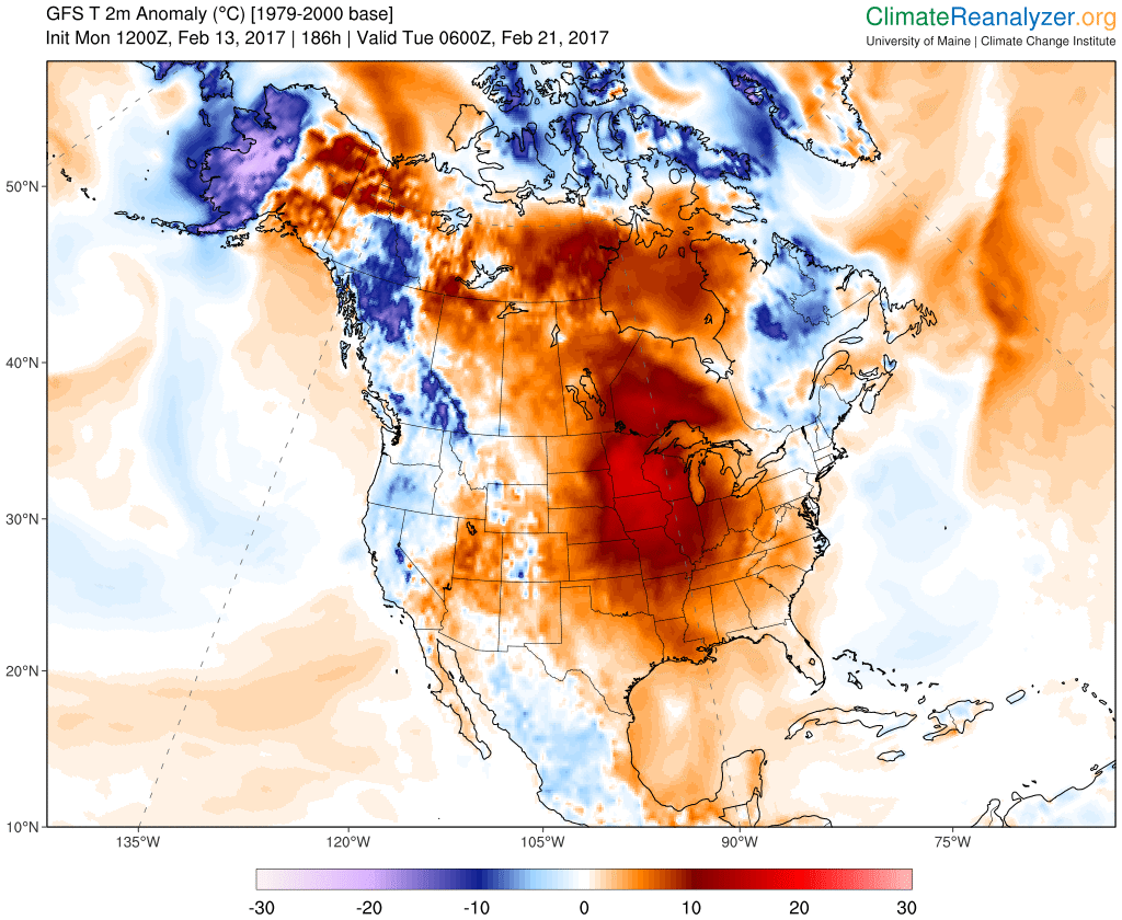
Temperatures will likely run 20 to 30 degrees warmer than average across Minnesota by next Monday. An unusually warm February air mass covers most of the United States and Canada.
I expect we will see many temperature records fall from next weekend into Monday, Feb. 20. Both overnight "record warm minimums" and daily record highs will be challenged.

Strange weather indeed. But increasingly less rare given the background hum of milder Midwest winters driven by climate change.
Briefly cooler
Our next "cool" front slides south across Minnesota overnight. A cool high pressure ridge slides overhead Wednesday, but milder air is already pooling to the west.

Tuesday features gusty northwest winds. But temperatures still hover in the mid to upper 30s, around 10 degrees warmer than average Tuesday. That's the sad state of affairs for "cold fronts" in Minnesota this month.
By Friday temperatures push 60 degrees across southern Minnesota.

Searching for snow cover
Snow depth typically peaks during the first half of February in Minnesota.
Not this year. Bare ground dominates southern Minnesota this week.

In Minnesota, Duluth still has 13 inches of snow, International Falls reports 18 inches and sections of the Boundary Waters still have 1 to 2 feet in many areas. Go (way) north if you want to play in snow.
Invisible weather
Here's an interesting time lapse that shows the hydrologic cycle at work. Watch the snow fall, then melt in the span of about 24 hours.
It's amazing what we can see, and still not fully comprehend as weather happens over different time scales.