Ugh: Snow and cold return for Wednesday commutes
It's only Tuesday, and this week is already getting old for Minnesota commuters.
Tuesday's snow shot delivered on the forecast 1" to 3" of fresh, wind-driven powder. We catch a break in snowfall into the overnight, but the next wave of snow develops just in time for Wednesday morning's commute.
How lovely.
Wednesday dusting
Create a More Connected Minnesota
MPR News is your trusted resource for the news you need. With your support, MPR News brings accessible, courageous journalism and authentic conversation to everyone - free of paywalls and barriers. Your gift makes a difference.
Wednesday's snow band develops on the leading edge of the next inbound Arctic air mass. Arctic air is notorious for paving the way by squeezing out a coating of Arctic fluff. A weak low pressure wave spins up to the south as the cold front drives southward.

Roads: Temperature critical
Wednesday's snow should be light, around an inch or two in most spots.

But with temperatures in the teens it won't take much to gum up roads once again. Road chemicals don't work nearly as well when temps are below 10 degrees. Even a snowy dusting can wreak havoc when temps hover below 10 degrees. That's why I'm anticipating another nasty commute Wednesday. Temps bottom out Friday morning in the -10 to 15 range in the inner metro core, with -20 and colder still likely points north.

Tracking the January Thaw
There's little doubt next week will be significantly warmer across the Upper Midwest. The only question seems to be the magnitude of the coming thaw. The big atmospheric picture of how a January thaw happens in Minnesota? A deep Polar Vortex over Alaska drives milder air into the USA and Upper Midwest.

The latest GFS runs tempers highs a bit into the low to mid 30s next week. We'll see. I expect the magnitude of the thaw a week out to change over the next few days. One things that seems certain. It's going to be a lot warmer around here next week.

History of the January Thaw
January thaws in Minnesota may not happen every year. But most years the temperature cracks the thawing point for at least a few days in January. I found this blurb from the Minnesota DNR's Climate Working Group on some of the more notable January thaws.
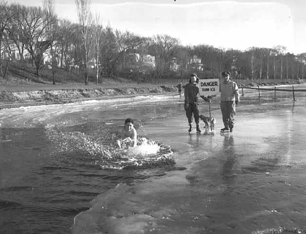
The warmest January thaw on record for the Twin Cities is 58 degrees on January 25, 1944. The Minneapolis Star Journal took a photo of a person taking a quick dip in a lake that was partially open. A close second is the 57 degrees reached on January 24, 1981. As recently as 2003, the thermometer has reached above 50 degrees in January in the Twin Cities. On January 8, 2003 the high was 53 degrees and it was nice enough for a pleasant walk or to rake leaves. The high has reached 50 degrees or higher in January eleven times in the Twin Cities since 1891.
Selected stories from the twitterverse
I had the pleasure of spending some of the holidays in skiing with friends and family in beautiful Park City, Utah.

The recent heavy snows out west are great for skiers and water resources. But avalanche danger grows by the day as heavy snows pile up. The difference in moisture content between individual snowfalls can create unstable layers that may give way and cause avalanches.
Crews actually set off explosions to try and trigger the slides before they can cause harm. Sounds like fun.
640 companies to Trump: Keep the clean energy revolution on track
The clean energy transition train has already left the station and is gaining speed. Adobe, SalesForce, eBay, HP, SolarCity, Symantec and Tesla? Why would Trump try and slow down the job creating momentum?
Do republican Presidents attract warmer weather on Inauguration Day?
There may be a climate metaphor here.
USA: Hot in 2016
USA temperature trends fit the record global pattern of 2016.