January temperature whiplash ahead; atmospheric rivers slam California
Heart of winter
Minnesota winter is in full swing. So far this winter is playing out fairly typically by Minnesota winter standards. But get ready; I see some wild temperature swings in the next 2-3 weeks across Minnesota.
Early predictions of a colder than average winter in the Upper Midwest by NOAA and other forecasters are not panning out. December, the first third of meteorological winter, finished 1.2 degrees warmer than average in the Twin Cities.
Snowfall for the Twin Cities is running slightly below seasonal average to date.
Create a More Connected Minnesota
MPR News is your trusted resource for the news you need. With your support, MPR News brings accessible, courageous journalism and authentic conversation to everyone - free of paywalls and barriers. Your gift makes a difference.
18.1" season snowfall so far at MSP Airport
23.3" average season snowfall to date at MSP
-5.2" vs. average so far
The number of sub-zero days in the Twin Cities is also running about average so far.
22.7 days at or below zero at MSP in an average winter (1981-2010)
7 days at or below zero so far this winter (that's about average through January 5th)
So by most metrics this is a fairly typical Minnesota winter so far. We reach the halfway point of meteorological winter in 10 about days. Looking ahead at the maps for the next 2-3 weeks, I see several up and down temperature cycles with occasional brief thaws and a couple more brief sub-zero shots. Overall January temperatures will likely wind up fairly close to average for the month.
As we approach the halfway point of meteorological winter, I still think we're on track for a winter that's close to or slightly warmer than average. Near average season snowfall somewhere between 50" to 60" still seems like a reasonable projection for the Twin Cities.
Greening grass in April looks likely once again. And summer will follow winter and spring.

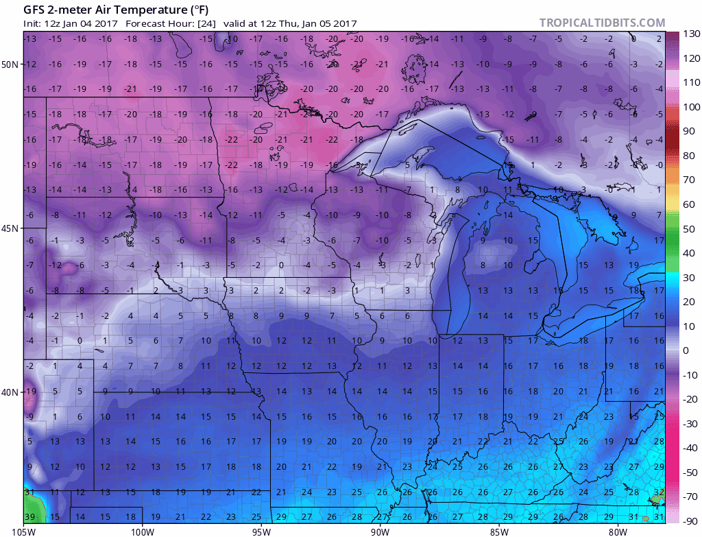
Respectable cold for now
Temps bottomed out at -6 at MSP Airport Wednesday morning. We add 4 more sub-zero mornings before temps begin to rebound Sunday afternoon. Temps push -20 in northern Minnesota the next few nights.
This is what an arctic air mass looks like over Minnesota. Watch the end of the temperature loop as temps push toward the thawing point in the Twin Cities next Tuesday.
Storm track stays south
The storm track across the USA stays south of Minnesota this week. Watch as the massive arctic high pressure dome literally shoves western storms into the Gulf Coast and Deep South this week. That's a typical January weather map. A piece of the active California storm track finally breaks through next Tuesday and sends a wintry mix toward Minnesota.

Long range: January temperature roller coaster ahead
The longer range maps look highly variable for Minnesota the rest of January. I can see some wild temperature swings this month, with brief thaws punctuated by quick sub-zero intrusions off the Arctic ice cap. Ups and downs. Strikes and gutters.

Major thaw around January 16-18th?
Our January thaw may be in sight. It's still early, but the longer range maps hint at a significant thaw around the January 16-18 time frame. Temps well into the 40s and the lowest mile of the atmosphere warm enough for January rain? Stay tuned.

Stay tuned.
Atmospheric rivers slam California
Where was this during last winter's El Nino?
A pipeline of tropical moisture we meteorologists call "atmospheric rivers" is taking aim at California coast.
The pattern is a blessing for still droughty California, delivering heavy rain and deep mountain snows.
The next AR delivers more heavy precip to California this weekend.
California snow-pack increasing
California snow-pack has increased to 84% of average statewide as of January 4th.

Another 2-3 storms in the next 10 days will likely push values well over 100% of average. That's good news for a state where snow-melt in spring is a lifeline for thirsty cities with 38 million people.
Here's more perspective from Mike McPhate at the New York Times on why California snow-pack is so closely monitored.
[image]
On Tuesday, state water officials trudged into the Sierra Nevada for the first snowpack survey of 2017.
Snowpack levels are crucial indicators of whether California will have enough water after the winter, as the melting snow flows into the state’s reservoirs.
The reading at Phillips Station, near Lake Tahoe, however, is a largely ceremonial exercise, attracting attention in part for its visual interest. (See photos below.) After dipping poles into the snow, surveyors said the snowpack there was at roughly half the historical average.
Much more telling, electronic readings across the whole of the Sierra Nevada on Tuesday indicated the snowpack was about 70 percent of normal.
Frank Gehrke, the state’s chief snow surveyor, said he was encouraged by rounds of rain and snowfall now sweeping the state that are helping to shore up reservoirs and the snowpack.
“I think it’s a good start,” he told reporters while standing in knee-deep snow at Phillips Station.
Still, the lackluster readings could spell trouble in the spring and summer, when California relies on runoff from the mountains to meet a third of its water needs.
While strong precipitation in parts of California since the fall has lifted hopes after five years of drought, scientists say warming temperatures in the Sierra Nevada has worked to suppress the snowpack.
“Just about every year since 2000 has been warmer than the preceding year,” said Doug Carlson, a spokesman for the California Department of Water Resources.
“So this is where global warming is really seen in our data here in California.”