First pictures from new satellite; Tuesday snow
The clouds and fog the past three days helped us accomplish one thing; we tied a record for consecutive January days above freezing in the Twin Cities:
Our average low temperature is 7 degrees in the Twin Cities this time of year, so it is very unusual to stay above 32 degrees for 3 consecutive days. We'll see if we dip to 32 degrees this morning or later this evening.
Thaw continues
Highs in the mid to upper 30s will be common across central and southern Minnesota today, with some lower 30s to the northwest.
Create a More Connected Minnesota
MPR News is your trusted resource for the news you need. With your support, MPR News brings accessible, courageous journalism and authentic conversation to everyone - free of paywalls and barriers. Your gift makes a difference.
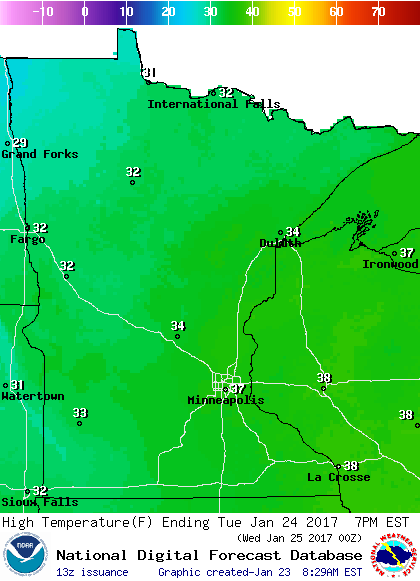
Similar high temps are on tap for Tuesday:
on
Twin Cities highs should reach the mid 30s Wednesday, around 30 Thursday, then upper 20s on Friday.
Snow returns Tuesday
The National Oceanic and Atmospheric Administration’s North American Mesoscale forecast model shows the potential snow pattern Tuesday through Wednesday afternoon, as a low-pressure system passes to our south:

The color chart on the lower right of the loop refers to the strength of the radar signal returning to the radar, not inches of snow!
The heaviest snow is expected over far southern Minnesota, where 6 inches or more are possible.
Here are potential snow totals for Tuesday and Wednesday:

The National Weather Service has issued a winter storm watch for southern Minnesota Tuesday and Wednesday:

Here are details of the south-central Minnesota portion of the winter storm watch:
URGENT - WINTER WEATHER MESSAGE
NATIONAL WEATHER SERVICE TWIN CITIES/CHANHASSEN MN
343 AM CST MON JAN 23 2017
...WINTER STORM TO IMPACT SOUTH CENTRAL MINNESOTA TUESDAY THROUGH
WEDNESDAY AFTERNOON...
.A WINTER STORM WATCH REMAINS IN EFFECT FOR ABOUT THE SOUTHERN
THIRD OF MINNESOTA TUESDAY AFTERNOON INTO WEDNESDAY AFTERNOON.
ACCUMULATING SNOW EXPECTED TO SPREAD INTO SOUTH CENTRAL MINNESOTA
TUESDAY MORNING...AND ACROSS MUCH OF THE REST OF SOUTHERN
MINNESOTA AND WESTER WISCONSIN BY TUESDAY EVENING. THE HEAVIEST
AMOUNTS ARE FORECAST TO BE ALONG AND SOUTH OF THE MINNESOTA RIVER
VALLEY WHERE 6 TO 8 INCHES ARE EXPECTED. SNOWFALL WILL BE
HEAVIEST TUESDAY EVENING WHEN SNOWFALL RATES OF 0.5-0.75" PER HOUR
ARE POSSIBLE ACROSS THE WATCH AREA. THE SNOW WILL MOVE EAST OF
THE AREA BY WEDNESDAY AFTERNOON BUT GUSTY NORTHWEST WINDS WILL
LEAD TO A THREAT FOR BLOWING AND DRIFTING SNOW. SNOW ON ROADS AND
LOW VISIBILITY FROM BLOWING AND DRIFTING SNOW WILL MAKE FOR
DIFFICULT TRAVEL ACROSS SOUTHERN MINNESOTA AND MOTORISTS ARE
ADVISED TO USE CAUTION.
MNZ073>078-082>085-091>093-231745-
/O.CON.KMPX.WS.A.0002.170124T1800Z-170125T2100Z/
REDWOOD-BROWN-NICOLLET-LE SUEUR-RICE-GOODHUE-WATONWAN-BLUE EARTH-
WASECA-STEELE-MARTIN-FARIBAULT-FREEBORN-
INCLUDING THE CITIES OF REDWOOD FALLS, NEW ULM, ST PETER,
LE SUEUR, FARIBAULT, RED WING, ST JAMES, MANKATO, WASECA,
OWATONNA, FAIRMONT, BLUE EARTH, AND ALBERT LEA
343 AM CST MON JAN 23 2017
...WINTER STORM WATCH REMAINS IN EFFECT FROM TUESDAY AFTERNOON
THROUGH WEDNESDAY AFTERNOON...
* TIMING...TUESDAY INTO WEDNESDAY AFTERNOON
* MAIN IMPACT...ACCUMULATING SNOW FROM 6 TO 8 INCHES WILL MAKE FOR
DIFFICULT TRAVEL
* OTHER IMPACTS...BLOWING AND DRIFTING SNOW WITH LOW
VISIBILITIES POSSIBLE WEDNESDAY
PRECAUTIONARY/PREPAREDNESS ACTIONS...
A WINTER STORM WATCH MEANS THERE IS A POTENTIAL FOR SIGNIFICANT
SNOW...SLEET...OR ICE ACCUMULATIONS THAT MAY IMPACT TRAVEL.
CONTINUE TO MONITOR THE LATEST FORECASTS.
The Twin Cities metro area is not in the winter storm watch, but the metro is expected to see enough snow to shovel.
An early estimate would be around 4 inches of snow in the metro area from Tuesday afternoon through Wednesday morning.
NOAA’s forecast plume shows the range of Minneapolis snow forecasts from different versions of forecast models:

The models give Minneapolis snow totals ranging from less than 1 inch on the low end to about 12 inches on the high end.
The average of the various models (thick black line) is between 4 and 5 inches.
We’ll keep you updated as new forecast info arrives.
New and improved GOES satellite data
The first images from NOAA's newest weather satellite have been released today:
GOES is short for Geostationary Operational Environmental Satellite system.
According to NOAA:
Since the GOES-16 satellite lifted off from Cape Canaveral on November 19, scientists, meteorologists and ordinary weather enthusiasts have anxiously waited for the first photos from NOAA’s newest weather satellite, GOES-16, formerly GOES-R.
The release of the first images today is the latest step in a new age of weather satellites. It will be like high-definition from the heavens.
The pictures from its Advanced Baseline Imager (ABI) instrument, built by Harris Corporation, show a full-disc view of the Western Hemisphere in high detail — at four times the image resolution of existing GOES spacecraft. The higher resolution will allow forecasters to pinpoint the location of severe weather with greater accuracy. GOES-16 can provide a full image of Earth every 15 minutes and one of the continental U.S. every five minutes, and scans the Earth at five times the speed of NOAA’s current GOES imagers.
NOAA’s GOES-16, situated in geostationary orbit 22,300 miles above Earth, will boost the nation’s weather observation network and NOAA’s prediction capabilities, leading to more accurate and timely forecasts, watches and warnings.
Here is one picture that was released today:

The caption read:
GOES-16 captured this view of the moon as it looked across the surface of the Earth on Jan. 15. Like earlier GOES satellites, GOES-16 will use the moon for calibration. (NOAA/NASA)
A GOES-16 image gallery has been posted.
It will be exciting to see the new higher definition satellite images and new products in the coming weeks and months!