Drizzle and showers south, wintry mix north
If gray is your favorite color, you'll love the next couple of days.
Dense fog is not as widespread across Minnesota this morning as it was yesterday, but dense fog advisories are in effect this morning for southwestern Minnesota and Traverse and Big Stone counties in west-central Minnesota.
We'll have periods of drizzle and light rain today and tonight in southern Minnesota. Central and northern Minnesota will see a wintry mix at times.
The Duluth office of the National Weather Service has issued a freezing rain advisory until noon today for parts of northern Minnesota, including Brainerd:
Create a More Connected Minnesota
MPR News is your trusted resource for the news you need. With your support, MPR News brings accessible, courageous journalism and authentic conversation to everyone - free of paywalls and barriers. Your gift makes a difference.
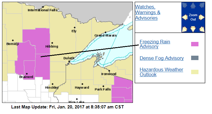
Here are some advisory details:
URGENT - WINTER WEATHER MESSAGE
NATIONAL WEATHER SERVICE DULUTH MN
836 AM CST FRI JAN 20 2017
...LIGHT FREEZING RAIN ACROSS PARTS OF CENTRAL AND NORTH CENTRAL
MINNESOTA THIS MORNING...
.LIGHT RAIN AND DRIZZLE SPREADING THROUGH PARTS OF CENTRAL AND
NORTH CENTRAL MINNESOTA THIS MORNING WILL RESULT IN SOME FREEZING
RAIN ON ROAD SURFACES. EVEN THOUGH AIR TEMPERATURES ARE SLIGHTLY
ABOVE FREEZING...ROAD TEMPERATURES ACROSS THE AREA ARE BELOW OR
NEAR THE FREEZING MARK...SO THE RAIN WILL FREEZE ON THE ROAD
SURFACES UNTIL THE ROAD TEMPERATURES WARM UP SUFFICIENTLY ENOUGH
BY THIS AFTERNOON. THERE HAVE BEEN MANY REPORTS OF SPIN OUTS IN
THE AREA. EXPECT SOME ICING TO CAUSE DIFFICULT TRAVEL CONDITIONS
IN SOME AREAS.
MNZ018-025-026-033>036-201800-
/O.NEW.KDLH.ZR.Y.0001.170120T1436Z-170120T1800Z/
NORTH ITASCA-NORTH CASS-SOUTH ITASCA-SOUTH CASS-CROW WING-
NORTHERN AITKIN-SOUTH AITKIN-
INCLUDING THE CITIES OF...BIGFORK...WALKER...GRAND RAPIDS...
PINE RIVER...BRAINERD...HILL CITY...AITKIN
836 AM CST FRI JAN 20 2017
...FREEZING RAIN ADVISORY IN EFFECT UNTIL NOON CST TODAY...
THE NATIONAL WEATHER SERVICE IN DULUTH HAS ISSUED A FREEZING RAIN
ADVISORY...WHICH IS IN EFFECT UNTIL NOON CST TODAY.
* LOCATIONS...PARTS OF CENTRAL AND NORTH CENTRAL
MINNESOTA...INCLUDING THE AITKIN...BRAINERD LAKES...AND GRAND
RAPIDS AREAS.
* ICE ACCUMULATIONS...LESS THAN FIVE HUNDREDTHS OF AN INCH.
* TIMING...THIS MORNING.
* IMPACTS....GLAZING ON ROAD SURFACES WILL CAUSE DIFFICULT TRAVEL
CONDITIONS THIS MORNING.
PRECAUTIONARY/PREPAREDNESS ACTIONS...
A FREEZING RAIN ADVISORY MEANS THAT PERIODS OF FREEZING RAIN OR
FREEZING DRIZZLE WILL CAUSE TRAVEL DIFFICULTIES. BE PREPARED FOR
SLIPPERY ROADS. SLOW DOWN AND USE CAUTION WHILE DRIVING.
Update
The National Weather Service has expanded the freezing rain advisory into central Minnesota and the northern part of the Twin Cities metro area until noon:

Off and on
Our precipitation will be intermittent today through Saturday.
The National Oceanic and Atmospheric Administration’s North American Mesoscale forecast model shows the potential precipitation pattern:

In the forecast loop, blue areas are where the precipitation is likely to be snow for that time in the loop. Purple areas are sleet or freezing rain. Green areas are likely to be rain, but the rain could freeze at ground level if surface temps are cold enough.
The color chart on the lower right of the loop refers to the strength of the radar signal returning to the radar, not inches of snow!
Thaw continues
How warm is this January thaw?
Our average high temperature this time of year is 24 degrees in the Twin Cities. So far today, the coldest reading at Minneapolis-St. Paul International Airport has been 35 degrees.
If it doesn't drop below 35 degrees before midnight, we'll tie the record for the warmest Jan. 20 low temperature in the Twin Cities.
Minnesota highs will be mostly in the upper 30s today.
On Saturday, some spots in southern Minnesota could touch 40:

Similar highs are on tap for Sunday.
Mild highs are expected next week and beyond.
The temperature outlook from NOAA's Climate Prediction Center shows a tendency for above normal temperatures Jan. 25 through Jan. 29:

Below-normal highs could return for the final two days of January, but this will be another warmer than normal month.
The last time that we had a cooler than normal month in the Twin Cities was way back in August of 2015!
Next snow
Snow lovers are not amused by this long duration January thaw.
Snow conditions for sledding and cross-country skiing will be sloppy this weekend. Outdoor ice rinks won't have ideal skating conditions either.
There's some hope for fresh snow next week!
NOAA's Global Forecast System model shows a low pressure system tracking just to our south next Tuesday and Wednesday:

Central and southern Minnesota could get enough snow to shovel next week.
We'll keep you updated!
Programming note
You can hear my live weather updates on Minnesota Public Radio at 7:35 a.m. and 4:35 p.m. each Saturday and Sunday.