Chilly today; warming trend this weekend
It's Friday the 13th, so we probably shouldn't expect "normal" weather.
I wouldn't call today's weather unlucky, it's just cold.
There won't be freezing rain or fat snowflakes to snarl up your commutes today, but your warmest coat and gloves will feel good.
Friday morning lows were in the single digits below zero in the Twin Cities metro area, but it was much colder over central and northern Minnesota.
Create a More Connected Minnesota
MPR News is your trusted resource for the news you need. With your support, MPR News brings accessible, courageous journalism and authentic conversation to everyone - free of paywalls and barriers. Your gift makes a difference.
Parts of north-central and northeastern Minnesota saw 30s below zero.
Minnesota highs today will be mostly in the single digits above zero, with a few spots in the south hitting double digits.
There's minimal wind today, but enough to warrant wind chill warnings over northwestern Minnesota until noon:
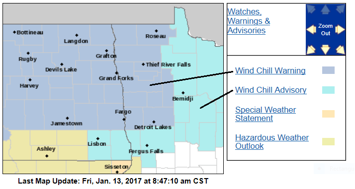
Wind chill temps of minus 40 to minus 45 degrees are possible this morning.
The remainder of northern Minnesota, including the arrowhead region, have wind chill advisories until noon today for wind chill temps of minus 25 to minus 40 degrees.
Warming trend
Highs rebound nicely tomorrow, with teens across most of Minnesota:

Some spots in southern Minnesota, including parts of the Twin Cities metro area, will see lower 20s.
Sunday will be even warmer, with lower 20s north and mid-20s in southern Minnesota and the Twin Cities:

The Twin Cities will have highs in the lower 30s Monday through Wednesday of next week, then upper 30s to around 40 Thursday and Friday.
Wintry mix
A low-pressure system will spread moisture over Minnesota and western Wisconsin late Sunday night and Monday.
With surface temps slightly below freezing and warmer temps aloft, freezing rain is a definite possibility on Monday.
The National Oceanic and Atmospheric Administration's Global Forecast System model shows the potential mix of precipitation on Monday:

In the forecast loop, blue areas are where the precipitation is likely to be snow for that time in the loop. Purple areas are sleet or freezing rain. Green areas are likely to be rain, but the rain could freeze at ground level if surface temps are cold enough.
The color chart on the lower right of the loop refers to the strength of the radar signal returning to the radar, not inches of snow!
Central and northern Minnesota will probably see mostly snow, with a wintry mix changing to snow Monday night elsewhere.
We'll keep you updated as we get closer to Monday.
Season snowfall update
The snowfall total at Minneapolis-St. Paul International Airport is 5 inches so far this month. That brings our 2016-2017 season snowfall total to 23.1 inches, which is 3.5 inches below normal.
Our 30-year average snow season total is 54.4 inches in the Twin Cities, according to the National Climatic Data Center.
Last snow season, we saw only 36.7 inches of snow in the Twin Cities.
Only three of the past 10 snow seasons have been snowier than normal, according to the National Weather Service snowfall data posted by the Minnesota State Climatology Office:

The 2013-2014 snow season was the last one with above normal snowfall in the Twin Cities.
Snow lovers will like to hear that we're only about half-way through our typical snow season.
With the warm weather that's expected this coming week, you might want to do your sledding and skiing this weekend.
Programming note
You can hear my live weather updates on Minnesota Public Radio at 7:35 a.m. and 4:35 p.m. each Saturday and Sunday.