Challenging commutes: Snow and wind today; thaw next week
What could be the most challenging week of winter for commuters continues today with another shot of snow and wind. Low pressure deepens and sails through the Upper Midwest today. The system drives another shot of snow and more slick roads for commuters. A second clipper brings another snowy swipe tomorrow.
Deepening low
Today's low pressure system deepens as it takes a Des Moines, Iowa, to Green Bay, Wis., track. Look for snowfall intensity to pick up at times today as the system races northeast. Gusty northwest winds kick in behind the low, and blowing snow becomes an issue midday into tonight.
Here's the National Oceanic and Atmospheric Administration's Global Forecast System model.
Create a More Connected Minnesota
MPR News is your trusted resource for the news you need. With your support, MPR News brings accessible, courageous journalism and authentic conversation to everyone - free of paywalls and barriers. Your gift makes a difference.

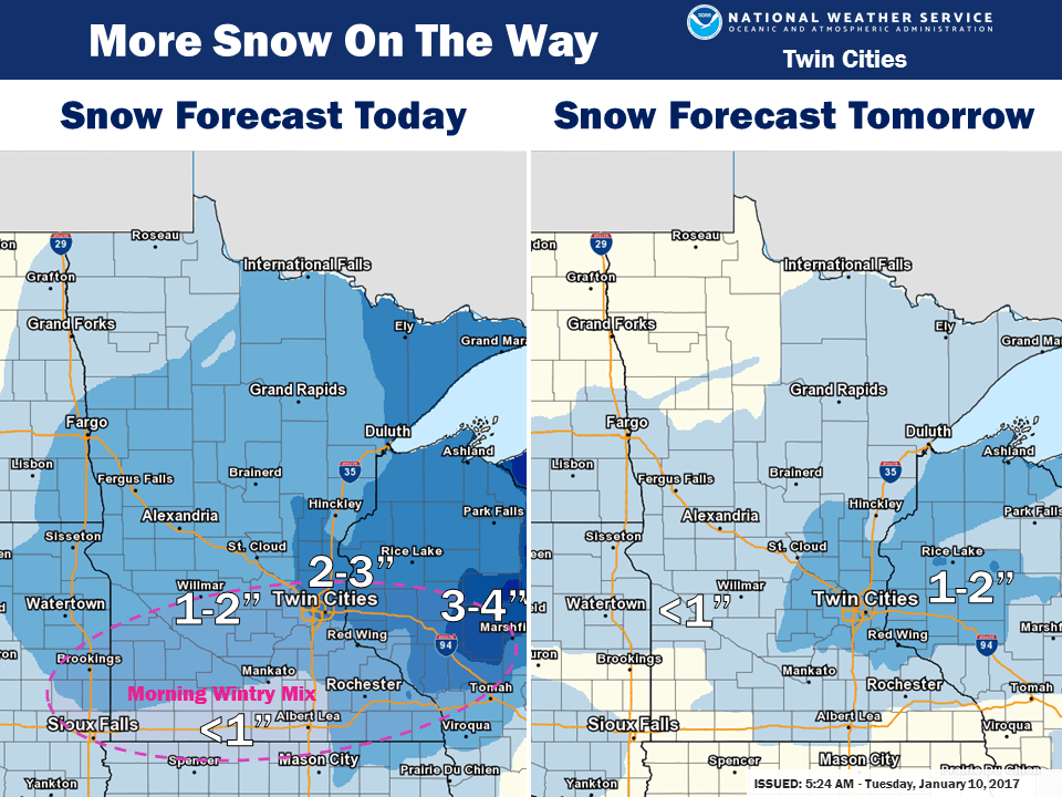
Localized heavier snow totals
Many of us should land in the 1 to 4-inches-plus snowfall range around the Twin Cities today. A few models crank out a heavier band of snowfall just southeast of the Twin Cities today. The favored zone from Northfield, Minn., through Red Wing, Minn., and Eau Claire, Wis., could pick up 3 to 6 inches-plus in a narrow band. Hopefully that band stays just southeast of the Twin Cities, or our collective commuter nightmare could grow. We add another inch or so Wednesday.

Briefly arctic
A brief arctic invasion, a glancing blow of polar pain arrives late this week. What this cold snap lacks in duration it will make up in intensity. Temps push minus 10 to minus 15 in the metro Friday morning, and minus 20s to minus 30 up north. Watch the pulses of Arctic air pour south.

January thaw next week
All signs still point to a much milder Pacific air flow next week. In fact, the upper air pattern by next Friday looks oddly unusual for late January. The jet stream shifts well north into Canada, opening the door to an unseasonably mild air mass over the U.S.

The temperature map across the country looks just plain weird by Jan. 21. This is January in the U.S.?

10 to 20 degrees higher than average
Next week could put a dent in snow cover across the Upper Midwest. Temperatures run a good 10 degrees higher than average, and push the +20F vs. average mark across northern Minnesota and southern Canada.

Unprecedented Arctic warmth
Our incredibly mild run the past 15 months in Minnesota may have connections in the Arctic. When it come to weather and climate the Arctic is not like Vegas. What happens in the Arctic doesn't stay in the Arctic. The lack of cold air in the Arctic may have a role in driving Minnesota's fifth-warmest year on record in 2016.
The big question: Is the incredible jump in Arctic temperatures just a blip, or a "step change" in climate?
Warmest year on record in Alaska
And the warm Arctic hit just keep on comin'. Alaska blew away warmth records in 2016.
The ground truth in Alaska? Landscape changes from fires, thawed permafrost and other unprecedented changes drive by climate change.
Ninety-one percent of days in 2016 were warmer than average on St. Paul Island? That's a symptom of a climate system seriously out of whack.