Arctic swipe next, tracking the January thaw next week
Our three-day snow siege has mercifully left the building.

Minnesota's weather pattern now goes into cold and dry mode. We endure about 48 hours of Polar pain from Thursday into Saturday morning. Temperatures go into recovery mode this weekend as 20s return.
By next week the birds that choose to stay here over a Minnesota winter may be practicing spring songs in your backyard.
Snowy landscape returns
Create a More Connected Minnesota
MPR News is your trusted resource for the news you need. With your support, MPR News brings accessible, courageous journalism and authentic conversation to everyone - free of paywalls and barriers. Your gift makes a difference.
Minneapolis-St. Paul International Airport picked up 5 inches of snow the past three days. A more typical winter landscape decorates much of Minnesota this week. Snow cover now extends south to about Des Moines, Iowa.
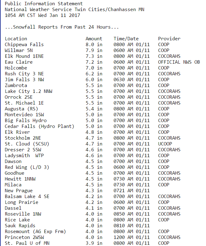
Here's a list of more 24-hour snowfall totals from the Twin Cities National Weather Service.
Almost arctic
Canadian high pressure drops south and sprawls over Minnesota Friday. As the high exits, southerly wind flow returns this weekend and milder air begins the return trip north. Another low-pressure system grazes Minnesota next Monday night into Tuesday morning with a potential wintry mix.

Our inbound air mass is not as barbaric as what we endured in mid-December when temps kissed minus 20 at MSP Airport. But Friday morning will get your attention as temps push minus 10 to minus 15 in the metro, colder north.

January thaw kicks in next week
There's are still some forecast model differences in the onset and magnitude of next week's January thaw. One thing that all models agree on, a big picture upper air pattern that gushes a "zonal" (west to east) Pacific air flow across the Lower 48 next week.

The National Oceanic and Atmospheric Administration's Global Forecast System 16-day temp outlook for the Twin Cities cranks out a string of days in the mid to upper 30s.
Temperatures in the lowest mile of the atmosphere still look warm enough for possible rain the weekend of Jan. 21.

Stay tuned.