Another 1″ to 3″ Tuesday; prolonged January thaw next week
Slip Slidin' Away
This is going to be a challenging week for commuters.
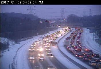
Monday's powder brought slick roads and numerous accidents on Twin Cities freeways.
More snow Tuesday
Create a More Connected Minnesota
MPR News is your trusted resource for the news you need. With your support, MPR News brings accessible, courageous journalism and authentic conversation to everyone - free of paywalls and barriers. Your gift makes a difference.
Another shot of light snow arrives Tuesday. This should be the biggest one of the week, with 1" to 3" snowfall totals likely across the Twin Cities. Watch NOAA's GFS model capture the icy overnight mix and Tuesday's snow shot as low pressure winds up and tracks quickly east. The good news? Warmer temps mean road chemicals will work better. Freeways and main roads may be mostly wet Tuesday.

Adding up inches
Another 1" to 3" falls Tuesday across the region. Yet another inch or so falls Wednesday and again with Arctic air Thursday, putting total snowfall this week into the 2" to 5" range for the metro. Heavier snows favor Wisconsin, where higher totals in excess of 6" are likely.

Brief Arctic slap
We endure about another 48 hours of Arctic air Thursday into Saturday. Temps make a run at -20 in the metro suburbs Friday morning, with -10 to -15 likely in the inner metro core. Up north, another night of -30 and colder in traditionally towns like Embarrass and Tower. Character building cold. But brief.

Extended January thaw next week
The models continue to advertise a milder southwest flow aloft over the USA next week. Check out the upper air map for next Thursday. A big cold Polar Vortex style low pressure system (blue) over Alaska means mild Pacific air (red) streaming across the USA into Minnesota.

Temps plunge to near -40 in the Yukon and Alaska, to near +40 in Minnesota, with spring-like 60s to the south.

Our January Thaw 2017 looks significant in magnitude and duration. Right now I see several days next week with highs in the 30s, and a shot at 40+ is certainly possible.

More winter rain
Meteorologists look at 850-millibar temperatures about a mile above ground (above) to gauge precip types in winter. If the 850mb temp is above the freezing point (0C), we can usually expect liquid rain at ground level. The air mass overhead still looks warm enough for more January rain in about 10 days. Yet another symptom of a warming winter climate in Minnesota.

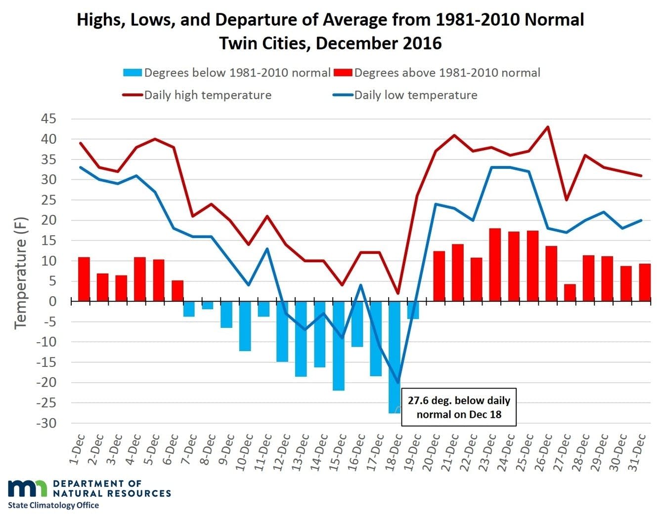
Crazy December caps off wild 2016 in Minnesota
You would be forgiven if you wondered what state you lived in in December in Minnesota. Wild temperature swings, and a Christmas Day rainstorm capped of a remarkable year for weather in Minnesota.
Top 5 weather events of 2016?
Mega rains, eternal autumn and the wettest year on record in the Twin Cities, Waseca and several other towns? Call it a job security program for Minnesota meteorologists.

It's hard to pick just one top weather event from last year's wild weather. The Minnesota DNR Climate Working Group assembled this excellent summary of the top 5 weather events of 2016.
Here are the results of voting for the top five weather events of 2016 from the Minnesota State Climatology Office.
Votes were cast from various weather enthusiasts including the National Weather Service, the University of Minnesota, State agencies and Facebook followers. Please visit us on Facebook and post your own top five weather events for Minnesota. It was a very warm and wet year across Minnesota, with multiple heavy rain events and severe storms. There were many weather events to choose from
In 2016, one could grow tomatoes in the Twin Cities right through November. The first 32 degree temperature in the autumn for the Twin Cities in 2016 was November 18. This smashed the old record of November 7, 1900. The season length wound up to be 219 days, handily breaking the old record of 207 days from 1894 and 1900.
#4 Tie for the warmest Autumn on record in Minnesota.
The average September to November Minnesota temperature finished in a tie for the warmest autumn on record with 49.7 degrees, which matches 1963. This is 6.5 degrees above the 1981-2010 normal. The coldest autumn on record is 1896, with 36 degrees or 7.2 degrees below normal.)
#3 Severe Storms Strike Northland Again: July 20-21, 2016
The Summer of 2016 was a stormy one, with northern Minnesota particularly hard hit. A line of intense thunderstorms swept across northern Minnesota during the late evening of July 20 into the early morning hours of July 21st. The Hallock Airport in Kittson County had a wind gust of 83 mph. Planes were flipped over at the Bemidji Airport. 75,000 Minnesota Power customers lost power. The storms also moved through the Boundary Waters Canoe Area Wilderness, tragically killing two campers on Basswood Lake in Quetico, just across the Minnesota border in Ontario.
#2 Central Minnesota Flash Flood July 11-12, 2016
The largest flash flood in Minnesota since the event of June 19-20, 2012 struck part of the same region on July 11-12, 2016. The highest two-day total was a volunteer reader in Pine County with 9.34 inches. Southbound I-35 and Highway 61 was closed for a time on July 12. The area covered by six inches or more of rainfall exceeded 2,000 square miles, qualifying it as a "Mega Rain" event. The flooding would have been worse had it not been for the relatively dry conditions beforehand. In addition to the heavy rain, there were three tornadoes, two of which were EF2. .
#1 State Record Precipitation Total at Waseca and Record Annual Twin Cities Precipitation.
The event that garnered the most votes was the statewide annual precipitation record set at Waseca and the Twin Cities annual record precipitation. The preliminary 2016 precipitation total at Waseca is 56.24 inches, handily breaking the old record at St. Francis in Anoka County of 53.52 inches in 1991. The 2016 total at Waseca breaks the old record by 2.72 inches. The Twin Cities also broke the annual precipitation record that was set over 100 years ago. The preliminary total for 2016 is 40.32 inches, breaking the old record of 40.15 inches set in 1911. The precipitation record for the Twin Cities begins in 1871.
UST's John Abraham on Science Friday
Frequent Climate Cast guest University of Saint Thomas Thermal Sciences Professor John Abraham on how to talk about climate change if you want to convince someone it’s happening. Hear his comments here on Science Friday.