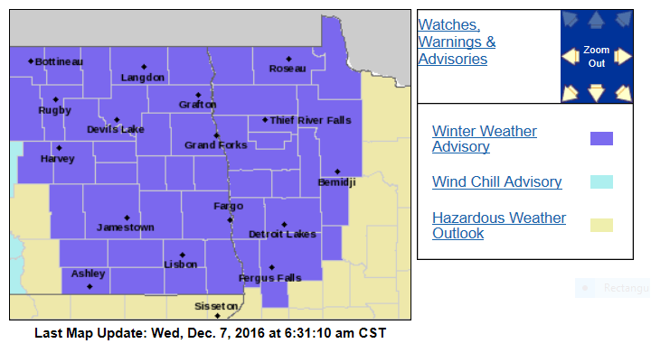
Winter weather advisory NW Minn., windy and cold
A low pressure system is located just north of Lake Superior today, and is moving slowly northeastward.
There are strong winds rotating around the low, and this will be a cold and windy day across Minnesota.
The Grand Forks, ND forecast office of the National Weather Service has issued a winter weather advisory for snow and blowing snow northwestern Minnesota until 6 p.m. today:
Create a More Connected Minnesota
MPR News is your trusted resource for the news you need. With your support, MPR News brings accessible, courageous journalism and authentic conversation to everyone - free of paywalls and barriers. Your gift makes a difference.
URGENT - WINTER WEATHER MESSAGE
NATIONAL WEATHER SERVICE GRAND FORKS ND
602 AM CST WED DEC 7 2016
MNZ001>004-007-008-013>015-022-027-029-030-040-NDZ006>008-014>016-
024-026>030-039-049-052>054-080000-
/O.EXP.KFGF.BZ.W.0004.000000T0000Z-161207T1200Z/
/O.CON.KFGF.WW.Y.0011.000000T0000Z-161208T0000Z/
WEST POLK-NORMAN-CLAY-KITTSON-WEST MARSHALL-EAST MARSHALL-
PENNINGTON-RED LAKE-EAST POLK-MAHNOMEN-WEST BECKER-WILKIN-
WEST OTTER TAIL-GRANT-TOWNER-CAVALIER-PEMBINA-BENSON-RAMSEY-
EASTERN WALSH COUNTY-EDDY-NELSON-GRAND FORKS-GRIGGS-STEELE-TRAILL-
CASS-RANSOM-SARGENT-RICHLAND-WESTERN WALSH COUNTY-
INCLUDING THE CITIES OF...CROOKSTON...EAST GRAND FORKS...ADA...
TWIN VALLEY...HALSTAD...MOORHEAD...HALLOCK...KARLSTAD...
LANCASTER...WARREN...STEPHEN...ARGYLE...NEWFOLDEN...
MIDDLE RIVER...GRYGLA...THIEF RIVER FALLS...RED LAKE FALLS...
FOSSTON...FERTILE...MCINTOSH...ERSKINE...MAHNOMEN...NAYTAHWAUSH...
WAUBUN...DETROIT LAKES...BRECKENRIDGE...FERGUS FALLS...
ELBOW LAKE...HOFFMAN...ASHBY...HERMAN...BARRETT...CANDO...
LANGDON...CAVALIER...WALHALLA...DRAYTON...PEMBINA...NECHE...
ST. THOMAS...FORT TOTTEN...MADDOCK...LEEDS...MINNEWAUKAN...
DEVILS LAKE...GRAFTON...PARK RIVER...NEW ROCKFORD...LAKOTA...
MCVILLE...ANETA...TOLNA...GRAND FORKS...COOPERSTOWN...FINLEY...
HOPE...MAYVILLE...HILLSBORO...HATTON...PORTLAND...FARGO...
LISBON...ENDERLIN...GWINNER...MILNOR...FORMAN...RUTLAND...
WAHPETON...EDINBURG...ADAMS...LANKIN
602 AM CST WED DEC 7 2016
...WINTER WEATHER ADVISORY REMAINS IN EFFECT UNTIL 6 PM CST THIS
EVENING...
...BLIZZARD WARNING WILL EXPIRE AT 6 AM CST EARLY THIS MORNING...
* IMPACTS...AREAS OF LIGHT SNOW AND BLOWING AND DRIFTING SNOW
TODAY WILL CAUSE LOCALLY REDUCED VISIBILITIES.
* ADDITIONAL SNOW ACCUMULATIONS...AROUND AN 1 INCH.
* WINDS...NORTHWEST 25 TO 35 MPH WITH GUSTS UP TO 45 MPH.
* VISIBILITIES...LOCALLY ONE HALF MILE OR LESS.
* WIND CHILL VALUES...5 BELOW TO 15 BELOW ZERO.
PRECAUTIONARY/PREPAREDNESS ACTIONS...
A WINTER WEATHER ADVISORY FOR BLOWING SNOW MEANS THAT
VISIBILITIES WILL BE LIMITED DUE TO STRONG WINDS BLOWING SNOW
AROUND. USE CAUTION WHEN TRAVELING...ESPECIALLY IN OPEN AREAS.
Here’s the simulated radar for today from the National Oceanic and Atmospheric Administration’s 4km resolution North American Mesoscale forecast model:
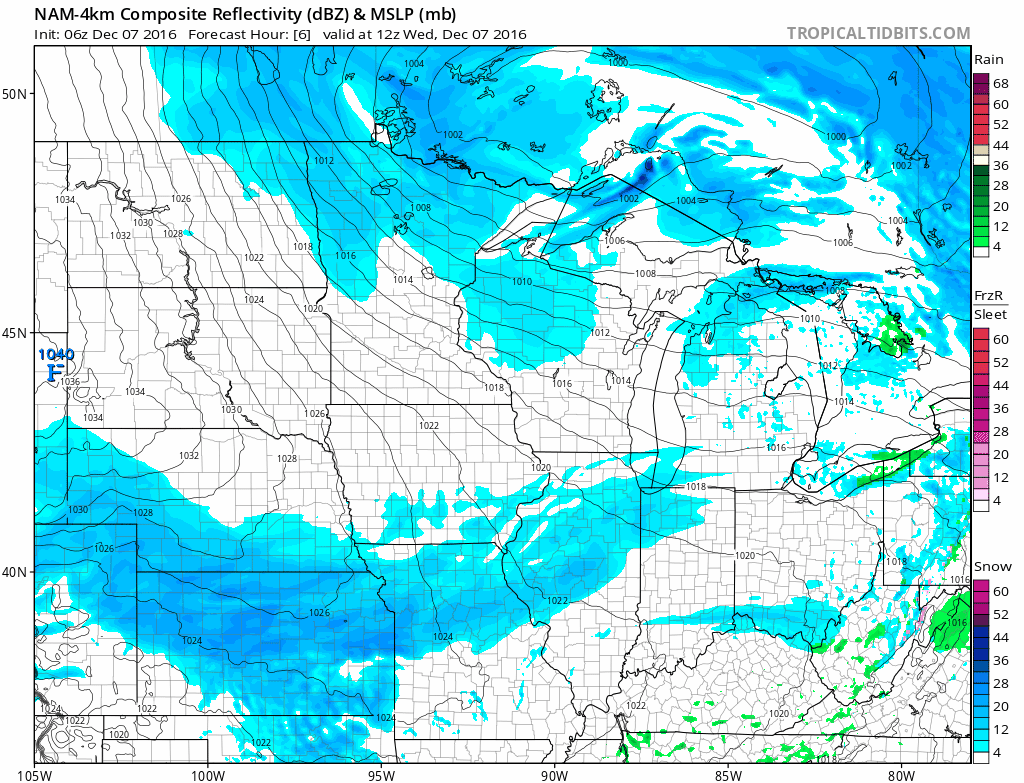
Minor snow accumulations are possible over northern Minnesota today, with occasional flurries in the south.
Highs today in Minnesota will be well below normal, ranging from the upper teems to lower 20s. Wind chill temps will be near zero for many spots.
Our next update will have details on our weekend snow possibilities.