Game on: Winter storm Friday, bitter cold next
Our next major winter storm of the season is moving into Minnesota. This one comes in 3 main pieces.
Light snow arrives overnight into Friday morning. Slick/icy roads impacting Friday morning rush hour.
The main body of the storm arrives Friday afternoon and evening with moderate to heavier snow.
Bitterly cold sub-zero air follows the storm Saturday night into Sunday and Monday.
Winter storm still on track
Create a More Connected Minnesota
MPR News is your trusted resource for the news you need. With your support, MPR News brings accessible, courageous journalism and authentic conversation to everyone - free of paywalls and barriers. Your gift makes a difference.
This may be one of the best advertised winter storms in modern history. That makes me nervous.
The low pressure system is still on track to glide south of Des Moines Friday. The system throws a lead wave of light snow with the warm front into southern Minnesota overnight into Friday morning. The main body of the storm, a large shield of light to moderate snow arrives Friday afternoon and night. Friday PM rush looks snow covered and slippery. Hey boss man, maybe a good idea to let your troops off early Friday?

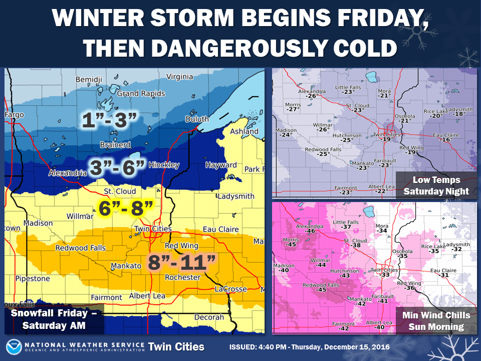
Winter storm warnings kick in Friday across Minnesota and a big chunk of real estate in the Upper Midwest.
325 PM CST THU DEC 15 2016
...WINTER STORM WARNING REMAINS IN EFFECT FROM NOON FRIDAY TO 6 PM CST SATURDAY...
* EXPECT SNOW TO DEVELOP AROUND NOON FRIDAY AND THEN DIMINISH AROUND 6 PM SATURDAY.
* THE HEAVIEST SNOWFALL RATES WILL OCCUR BETWEEN 6 PM FRIDAY AND MIDNIGHT SATURDAY.
* TOTAL SNOW ACCUMULATIONS OF 6 TO 10 INCHES ARE EXPECTED.
* WINDS GUSTING AS HIGH AS 30 MPH WILL CAUSE PATCHY BLOWING AND DRIFTING SNOW. IN ADDITION...SOME REDUCTIONS TO VISIBILITY ARE EXPECTED.
* EXPECT WIND CHILLS TO RANGE FROM 5 ABOVE ZERO TO 30 BELOW ZERO BETWEEN NOON FRIDAY AND 6 PM SATURDAY...WITH THE COLDEST WIND CHILLS OCCURRING AROUND 5 PM SATURDAY.
* PLAN ON DIFFICULT DRIVING CONDITIONS. THE DANGEROUSLY COLD WIND CHILLS WILL CAUSE FROSTBITE IN AS LITTLE AS 10 MINUTES TO EXPOSED SKIN.
Efficient snow-maker
Anytime you have air this cold in place, the snow-making process is efficient. Moisture overruns the massive cold dome near the ground. The result is a big zone of moderate snow Friday night. Large snow crystals, stellar dendrites are good at piling up big snowfall totals.

A wide zone of 6"+ should cover the southern half of Minnesota, northern Iowa and much of Wisconsin by Saturday. Totals could approach a foot from Rochester and La Crosse to Tomah and Madison. Not the best day for a trip down I-94 to the Wisconsin Dells?

How much in my back yard?
Everybody want to focus on inches, but you can make the case that the impact of 5 inches of snow is the same as 8 inches. Model guidance is cranking out about .50" liquid with this system. Do the math at a 15:1 snow to water ratio and you get 7.5" of snow. Your results may vary.

If you are fortunate enough to get under a persistent moderate or briefly convective heaver snow band, I could see some 10" to 12" totals across southern Minnesota. Good luck.
Coldest air in 20 years by Sunday?
It may be academic, but we could see the coldest air in 3 to 20 years depending on how cold it gets Sunday. If we get to -24 it will be the coldest at MSP since 1996. That kind of cold can get you doing the Macarena to stay warm.
To my eye -20 looks likely at MSP Sunday morning. The suburbs and most of southern Minnesota could dip to -25 as the core of the coldest air slides overhead Sunday morning. Western Minnesota could see -30 around Ortonville.
Look for stupid cold weather tricks from your local TV meteorologist Sunday.

Dangerous cold
Yes, we're hearty winter tough Minnesotans. But Sunday's level of cold is not just bracing, it's dangerous. Local emergency rooms get a flood of people with frostbite in this kind of cold. Tailgating before the Vikings game Sunday?
Don't be that guy.
50 degrees warmer next week
The overall pattern looks progressive in the next few weeks. That means our cold shot will be bitter, but brief. Watch the Polar Vortex spin east as milder Pacific flow returns to Minnesota next week.

Temps recover from sub-zero levels by Tuesday. Highs reach the 30s in MSP next week.

Another potential snow event looks possible in the middle of next week.
Stay tuned.