December thaw: 60 degrees warmer; Christmas storm potential
Thermometers across Minnesota get a good workout this week.
We endured the coldest temperatures in nearly three years Sunday. Temps hit minus 20 at the Minneapolis-St. Paul International airport for the first time since January 2014. Many metro suburbs hit minus 25, with minus 30 as close as Hutchinson. Embarrass posted a respectable minus 38 Sunday. It's beginning to look (and feel) a lot like winter across Minnesota these days.

Next, we watch as milder southerly flow returns, and thermometers soar through the 30s nudging 40 degrees across southern Minnesota late Tuesday afternoon. Some towns in southern Minnesota will be 60 degrees warmer Tuesday afternoon than they were Sunday morning.
This winter is off and running with cold and snow. December temps are lower than average so far, with snowfall close to seasonal averages. I still think we're on track for a winter with temps and snowfall close to average overall. And yes, I fully expect more subzero outbreaks. I won't be shocked to see more sustained cold and watch us make another run at minus 20 in the Twin Cities again in January.
Create a More Connected Minnesota
MPR News is your trusted resource for the news you need. With your support, MPR News brings accessible, courageous journalism and authentic conversation to everyone - free of paywalls and barriers. Your gift makes a difference.
A real Minnesota winter? What a concept.
18.1" season snowfall at MSP airport
+1.0" vs. average
5.9" season snowfall to date last year
December thaw
There's nothing to stop arctic air between the Twin Cities and the North Pole except a barbed wire fence. The same holds true for milder air from the Gulf of Mexico. It won't get that balmy here in the next 36 hours, but you'll be amazed at how good 30s will feel tomorrow. Towns like Hutchinson will go from minus 30 Sunday morning to +30 and higher tomorrow. A 60-degree warmup in less than 60 hours? Only in Minnesota.

Milder pattern
December appears determined to try and even out the cold of the past few days. Overall temps look to run above average the next two weeks. Average high is 25 and average low is 11 by Thursday. We'll crack 30 multiple days this week in the Twin Cities. A high of 34 could be conservative tomorrow.

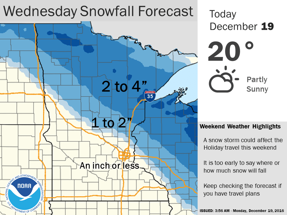
Wednesday clipper
A minor clipper sails through Wednesday. It looks like alight wintry mix for the metro starting later on the morning through midday. Northern Minnesota should see all snow, and could pick up 2 inches to 4 inches by Wednesday night.
Christmas storm?
It's early, but forecast models are cranking out a pretty potent low pressure storm moving toward the Upper Midwest Christmas Eve night into Christmas Day. Unlike the last two storms, track and precip type may be an issue with this one for the Twin Cities. The Euro is advertising all snow at this point for the Twin Cities. NOAA's GFS model tracks the storm further north, and changes snow to rain on Christmas Day.
Warning Label: This model can and probably will change this far in advance.

I'll leave the potential snowfall total speculation six days in advance to others. Suffice to say somebody in Minnesota could get a pile of snow for Christmas. Fire up the sled and the cross country skis. But Santa may bring some of us a snow to rain mix.
Stay tuned.