Chilly recap; warming trend starts on Monday
It has to get warmer.
Our Sunday featured morning lows in the 20s below zero, with a few spots dipping beyond 30 below.
Here are some of the coldest Sunday morning temperatures, as listed by the Twin Cities office of the National Weather Service:
Create a More Connected Minnesota
MPR News is your trusted resource for the news you need. With your support, MPR News brings accessible, courageous journalism and authentic conversation to everyone - free of paywalls and barriers. Your gift makes a difference.
Public Information Statement
National Weather Service Twin Cities/Chanhassen MN
916 AM CST Sun Dec 18 2016
...Low Temperature Reports December 18th...
Location Temp Time/Date Provider
Foley 6WSW -32 F 0800 AM 12/18 MNDOT
Redwood Falls 1ESE -31 F 0804 AM 12/18 AWS
Morton -31 F 0815 AM 12/18 MNDOT
Mayer 1NE -31 F 0810 AM 12/18 MNDOT
Hutchinson AP -30 F 0833 AM 12/18 AWOS
Wild River (State Pk) -30 F 0830 AM 12/18 COOP
St. Francis 1S -30 F 0803 AM 12/18 CWOP
Flensburg 2SSW -30 F 0832 AM 12/18 CWOP
Dundas 5WNW -29 F 0800 AM 12/18 MNDOT
Little Falls 2SSE -29 F 0707 AM 12/18 RAWS
Winthrop 2W -29 F 0840 AM 12/18 MNDOT
Randall -29 F 0833 AM 12/18 CWOP
New Prague 2W -29 F 0640 AM 12/18 MNDOT
Clara City 2WSW -29 F 0750 AM 12/18 MNDOT
Waconia 1WSW -29 F 0729 AM 12/18 AWS
Paynesville AP -29 F 0833 AM 12/18 AWOS
Clearwater 1SE -29 F 0800 AM 12/18 MNDOT
Sauk Centre AP -28 F 0731 AM 12/18 AWOS
Hutchinson 1WSW -28 F 0720 AM 12/18 AWS
Cedar Mills 5N -28 F 0830 AM 12/18 CWOP
Hanley Falls -28 F 0630 AM 12/18 MNDOT
St. Cloud 10 SW -28 F 0809 AM 12/18 AWS
Redwood Falls AP -28 F 0753 AM 12/18 ASOS
Montevideo 1 SE -28 F 0824 AM 12/18 AWS
New Germany 1NW -28 F 0835 AM 12/18 MNDOT
Cokato 2W -28 F 0744 AM 12/18 AWS
Granite Falls AP -28 F 0612 AM 12/18 AWOS
Rice -28 F 0700 AM 12/18 COOP
Melrose -28 F 0700 AM 12/18 COOP
Henderson 4ENE -28 F 0715 AM 12/18 MNDOT
Silver Lake 3E -27 F 0415 AM 12/18 MNDOT
Owatonna AP -27 F 0815 AM 12/18 AWOS
Belgrade 3ESE -27 F 0820 AM 12/18 MNDOT
Waseca 1SSE -27 F 0805 AM 12/18 MNDOT
Blue Earth 2NW -27 F 0830 AM 12/18 MNDOT
Montevideo 1SW -27 F 0700 AM 12/18 COOP
Litchfield 3S -27 F 0711 AM 12/18 RAWS
Willmar AP -27 F 0647 AM 12/18 AWOS
Madison AP -27 F 0653 AM 12/18 AWOS
Zimmerman -27 F 0813 AM 12/18 CWOP
Milaca -27 F 0730 AM 12/18 COOP
Fairmont AP -27 F 0756 AM 12/18 AWOS
Ellendale 5NNE -27 F 0716 AM 12/18 MNDOT
New Ulm AP -27 F 0634 AM 12/18 AWOS
Springfield 1NW -27 F 0747 AM 12/18 CWOP
Sauk Centre 2SE -27 F 0740 AM 12/18 MNDOT
Princeton AP -27 F 0754 AM 12/18 AWOS
Appleton AP -27 F 0714 AM 12/18 AWOS
At 9 a.m. Sunday, the official temperature at Minneapolis-St. Paul International Airport was 20 below zero. That was the coldest official Twin Cities temp since we hit 23 below zero on January 6, 2014. That was during the “polar vortex” winter of 2013-2014.
Minnesotans endured wind chill temperatures in the -30 to -50 range Saturday night and Sunday morning.
Wind chill advisories continued into Sunday night for portions of southwestern and northeastern Minnesota, as well as western Wisconsin.
Southeastern Minnesota has a wind chill advisory, for wind chill temps in the -20 to -30 range, until 6 a.m. Monday.
Goodbye to negative numbers
Winds at the upper levels of the atmosphere have been coming out of the northwest during most of our cold spell.
That upper level flow is flattening out as we start the week, becoming more west to east.
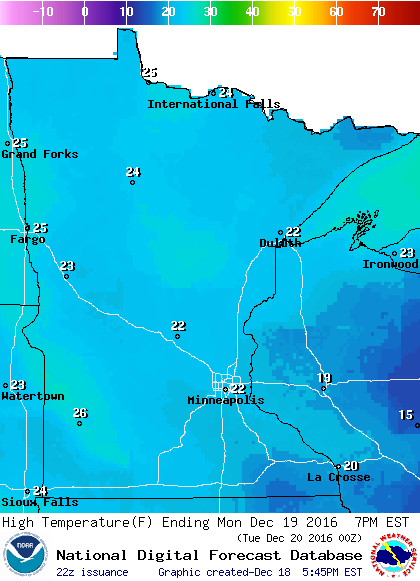
The milder upper air pattern will combine with surface winds from the southwest on Monday, giving us highs in the 20s:
The warming trend continues on Tuesday, with highs popping into the lower 30s over southern and central Minnesota:

Tuesday will be our first warmer than normal day in the Twin Cities since December 6th!
Highs on Wednesday will be similar to Tuesday's highs, then we'll see a slight dip into the 20s for Thursday and Friday.
Wednesday snow?
Northern Minnesota could see occasional flakes late Monday into Tuesday.
We could see some periods of snow over most of Minnesota Wednesday into Wednesday night.
As of now, it doesn't look like a big snowstorm, but some spots could see enough to shovel.
NOAA’s Global Forecast System model shows a low pressure system tracking across Minnesota:

Programming note
You can hear my live weather updates on Minnesota Public Radio at 7:35 a.m. and 4:35 p.m. each Saturday and Sunday.