Blizzard warning NW Minn. until 9 a.m. Wednesday
A slow-moving low pressure system dumped over a foot of snow on Grand Forks, ND on Tuesday.
Northwestern Minnesota also saw some double digit snowfall amounts, included 10.3 inches in the Marshall county city of Warren.
Strong winds from the storm will continue overnight and early Wednesday morning.
The Grand Forks, ND forecast office of the National Weather Service has issued a blizzard warning for northwestern Minnesota until 9 a.m. Wednesday:
Create a More Connected Minnesota
MPR News is your trusted resource for the news you need. With your support, MPR News brings accessible, courageous journalism and authentic conversation to everyone - free of paywalls and barriers. Your gift makes a difference.
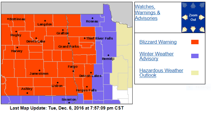
Here are more details, from the Grand Forks, ND office of the NWS:
URGENT - WINTER WEATHER MESSAGE
NATIONAL WEATHER SERVICE GRAND FORKS ND
724 PM CST TUE DEC 6 2016
MNZ001>004-007-008-013>015-022-027-NDZ006>008-014>016-024-026>030-
038-039-054-071500-
/O.CON.KFGF.BZ.W.0004.000000T0000Z-161207T1500Z/
WEST POLK-NORMAN-CLAY-KITTSON-WEST MARSHALL-EAST MARSHALL-
PENNINGTON-RED LAKE-EAST POLK-MAHNOMEN-WEST BECKER-TOWNER-
CAVALIER-PEMBINA-BENSON-RAMSEY-EASTERN WALSH COUNTY-EDDY-NELSON-
GRAND FORKS-GRIGGS-STEELE-TRAILL-BARNES-CASS-WESTERN WALSH COUNTY-
INCLUDING THE CITIES OF...CROOKSTON...EAST GRAND FORKS...ADA...
TWIN VALLEY...HALSTAD...MOORHEAD...HALLOCK...KARLSTAD...
LANCASTER...WARREN...STEPHEN...ARGYLE...NEWFOLDEN...
MIDDLE RIVER...GRYGLA...THIEF RIVER FALLS...RED LAKE FALLS...
FOSSTON...FERTILE...MCINTOSH...ERSKINE...MAHNOMEN...NAYTAHWAUSH...
WAUBUN...DETROIT LAKES...CANDO...LANGDON...CAVALIER...WALHALLA...
DRAYTON...PEMBINA...NECHE...ST. THOMAS...FORT TOTTEN...MADDOCK...
LEEDS...MINNEWAUKAN...DEVILS LAKE...GRAFTON...PARK RIVER...
NEW ROCKFORD...LAKOTA...MCVILLE...ANETA...TOLNA...GRAND FORKS...
COOPERSTOWN...FINLEY...HOPE...MAYVILLE...HILLSBORO...HATTON...
PORTLAND...VALLEY CITY...FARGO...EDINBURG...ADAMS...LANKIN
724 PM CST TUE DEC 6 2016
...BLIZZARD WARNING REMAINS IN EFFECT UNTIL 9 AM CST WEDNESDAY...
* TIMING...TONIGHT INTO WEDNESDAY MORNING.
* ADDITIONAL SNOW ACCUMULATIONS...LESS THAN 1 INCH.
* WINDS...NORTHWEST 30 TO 40 MPH WITH GUSTS UP TO 55 MPH.
* VISIBILITIES...NEAR ZERO IN OPEN COUNTRY.
PRECAUTIONARY/PREPAREDNESS ACTIONS...
A BLIZZARD WARNING MEANS SEVERE WINTER WEATHER CONDITIONS ARE
EXPECTED OR OCCURRING. FALLING AND BLOWING SNOW WITH STRONG WINDS
AND POOR VISIBILITIES ARE LIKELY. THIS WILL LEAD TO WHITEOUT
CONDITIONS...MAKING TRAVEL EXTREMELY DANGEROUS. DO NOT TRAVEL. IF
YOU MUST TRAVEL...HAVE A WINTER SURVIVAL KIT WITH YOU. IF YOU GET
STRANDED...STAY WITH YOUR VEHICLE.
To the east of the blizzard warning, there is a winter weather advisory in effect until 9 a.m. Wednesday:
URGENT - WINTER WEATHER MESSAGE
NATIONAL WEATHER SERVICE GRAND FORKS ND
724 PM CST TUE DEC 6 2016
MNZ005-006-009-016-071500-
/O.CAN.KFGF.WS.W.0005.000000T0000Z-161207T1500Z/
/O.EXA.KFGF.WW.Y.0011.000000T0000Z-161207T1500Z/
ROSEAU-LAKE OF THE WOODS-NORTH BELTRAMI-NORTH CLEARWATER-
INCLUDING THE CITIES OF...ROSEAU...WARROAD...GREENBUSH...
BAUDETTE...RED LAKE...REDBY...PONEMAH...BAGLEY...CLEARBROOK
724 PM CST TUE DEC 6 2016
...WINTER WEATHER ADVISORY IN EFFECT UNTIL 9 AM CST WEDNESDAY...
...WINTER STORM WARNING IS CANCELLED...
THE NATIONAL WEATHER SERVICE IN GRAND FORKS HAS ISSUED A WINTER
WEATHER ADVISORY FOR SNOW AND BLOWING SNOW...WHICH IS IN EFFECT
UNTIL 9 AM CST WEDNESDAY. THE WINTER STORM WARNING HAS BEEN
CANCELLED.
* TIMING...TONIGHT INTO WEDNESDAY MORNING.
* ADDITIONAL SNOW ACCUMULATIONS...1 TO 2 INCHES.
* WINDS...NORTHWEST 20 TO 30 MPH WITH GUSTS UP TO 40 MPH.
* VISIBILITIES...ONE HALF MILE OR LESS AT TIMES.
PRECAUTIONARY/PREPAREDNESS ACTIONS...
A WINTER WEATHER ADVISORY MEANS THAT PERIODS OF SNOW WILL CAUSE
TRAVEL DIFFICULTIES. BE PREPARED FOR SLIPPERY ROADS AND LIMITED
VISIBILITIES...AND USE CAUTION WHILE DRIVING. THE LATEST ROAD
CONDITIONS FOR THE STATE YOU ARE CALLING FROM CAN BE OBTAINED BY
CALLING 5 1 1.
Here’s the simulated radar for overnight and Wednesday morning, from the National Oceanic and Atmospheric Administration’s 4km resolution North American Mesoscale forecast model:

You can see updated winter storm information on our severe weather live blog.
Please share your photos and storm reports with our Public Insight Network and we can include them in our coverage.
The Minnesota Department of Transportation has current road conditions.
Cold temps
Our average high this time of year is 30 degrees in the Twin Cities metro area.
We aren't likely to see 30s anytime soon.
Highs Wednesday will be in the teens over northern Minnesota:

We should see lower 20s in the Twin Cities, but strong winds will give us wind chill temps in the single digits.
Occasional flurries are also possible.
Similar high temps are expected on Thursday:

This cold snap inspired a reminder from the Twin Cities NWS:
Weekend snow?
If you are a snow-lover waiting for flakes, you'll like this Saturday night weather chart from NOAA's Global Forecast System model:

The GFS model shows a low pressure system moving across northern Iowa, which would bring snow to southern and central Minnesota.
We'll be watching that as we get closer to the weekend!