Blizzard warning and winter storm warning NW Minn. until midnight
The National Weather Service has extended the blizzard warning and winter storm warning for northwestern Minnesota until midnight:
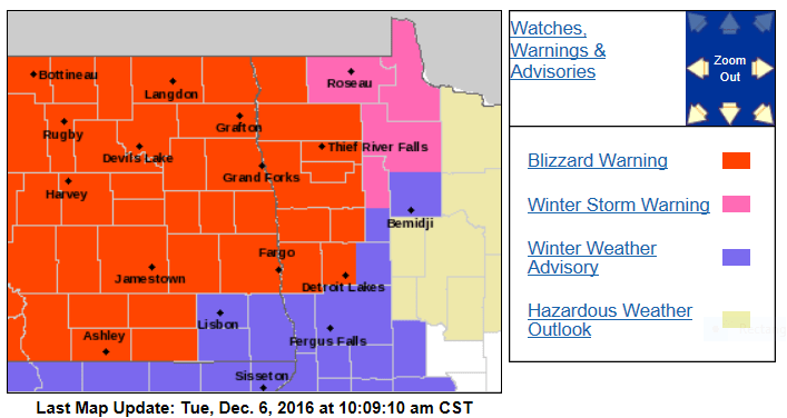
Here are more details, from the Grand Forks, ND office of the NWS:
STRONG WINDS COMBINED WITH FALLING SNOW WILL LEAD TO BLIZZARD OR NEAR
BLIZZARD CONDITIONS DEVELOPING FROM WEST TO EAST ACROSS MUCH OF
EASTERN NORTH DAKOTA AND NORTHWEST MINNESOTA DURING THE MORNING
OR EARLY AFTERNOON HOURS. CONDITIONS WILL BE WORST ACROSS
NORTHEAST NORTH DAKOTA INTO NORTHWEST MINNESOTA WHERE 6 TO 10 INCHES
OF SNOW FELL LAST NIGHT. ADDITIONALLY...SIGNIFICANT DRIFTING SNOW
AND RESULTANT IMPACTS ARE EXPECTED.
URGENT - WINTER WEATHER MESSAGE
NATIONAL WEATHER SERVICE GRAND FORKS ND
911 AM CST TUE DEC 6 2016
MNZ001-004-007-008-013>015-070600-
/O.EXT.KFGF.BZ.W.0004.161206T1800Z-161207T0600Z/
/O.CON.KFGF.WS.W.0005.000000T0000Z-161206T1800Z/
WEST POLK-KITTSON-WEST MARSHALL-EAST MARSHALL-PENNINGTON-RED LAKE-
EAST POLK-
INCLUDING THE CITIES OF...CROOKSTON...EAST GRAND FORKS...
HALLOCK...KARLSTAD...LANCASTER...WARREN...STEPHEN...ARGYLE...
NEWFOLDEN...MIDDLE RIVER...GRYGLA...THIEF RIVER FALLS...
RED LAKE FALLS...FOSSTON...FERTILE...MCINTOSH...ERSKINE
911 AM CST TUE DEC 6 2016
...WINTER STORM WARNING REMAINS IN EFFECT UNTIL NOON CST TODAY...
...BLIZZARD WARNING NOW IN EFFECT FROM NOON TODAY TO MIDNIGHT CST
TONIGHT...
* TIMING...SNOW WILL CONTINUE THROUGH THE DAY AND THEN DIMINISH
THIS EVENING. BLIZZARD CONDITIONS WILL DEVELOP EARLY THIS
AFTERNOON AND CONTINUE INTO TONIGHT.
* SNOW ACCUMULATIONS...ADDITIONAL 3 TO 7 INCHES OF SNOW. STORM
TOTAL 8 TO 15 INCHES.
* WINDS...NORTHWEST 30 TO 40 MPH WITH GUSTS UP TO 50 MPH.
* VISIBILITIES...NEAR ZERO TO WHITEOUT AT TIMES.
PRECAUTIONARY/PREPAREDNESS ACTIONS...
A BLIZZARD WARNING MEANS SEVERE WINTER WEATHER CONDITIONS ARE
EXPECTED OR OCCURRING. FALLING AND BLOWING SNOW WITH STRONG WINDS
AND POOR VISIBILITIES ARE LIKELY. THIS WILL LEAD TO WHITEOUT
CONDITIONS...MAKING TRAVEL EXTREMELY DANGEROUS. DO NOT TRAVEL. IF
YOU MUST TRAVEL...HAVE A WINTER SURVIVAL KIT WITH YOU. IF YOU GET
STRANDED...STAY WITH YOUR VEHICLE.
Create a More Connected Minnesota
MPR News is your trusted resource for the news you need. With your support, MPR News brings accessible, courageous journalism and authentic conversation to everyone - free of paywalls and barriers. Your gift makes a difference.
Less snow is expected in the southern part of the warning area, including Moorhead, Minn., and Detroit Lakes, Minn.
Everyone in northwestern Minnesota will see the winds pick up this afternoon, causing whiteout conditions at times.
The NWS weather glossary defines a blizzard warning as:
Issued for winter storms with sustained or frequent winds of 35 mph or higher with considerable falling and/or blowing snow that frequently reduces visibility to 1/4 of a mile or less. These conditions are expected to prevail for a minimum of 3 hours.
Here’s the simulated radar for this afternoon and evening, from the National Oceanic and Atmospheric Administration’s 4km resolution North American Mesoscale forecast model:

Advisories western MN
For Fergus Falls, and much of west central Minnesota, there is a winter weather advisory until midnight:

Here are more details, from the Twin Cities office of the NWS:
URGENT - WINTER WEATHER MESSAGE
NATIONAL WEATHER SERVICE GRAND FORKS ND
911 AM CST TUE DEC 6 2016
MNZ029>031-040-070600-
/O.EXT.KFGF.WW.Y.0011.000000T0000Z-161207T0600Z/
WILKIN-WEST OTTER TAIL-EAST OTTER TAIL-GRANT-
INCLUDING THE CITIES OF...BRECKENRIDGE...FERGUS FALLS...PERHAM...
NEW YORK MILLS...PARKERS PRAIRIE...HENNING...BATTLE LAKE...
ELBOW LAKE...HOFFMAN...ASHBY...HERMAN...BARRETT
911 AM CST TUE DEC 6 2016
...WINTER WEATHER ADVISORY NOW IN EFFECT UNTIL MIDNIGHT CST
TONIGHT...
* TIMING...PERIODS OF SNOW AND BLOWING SNOW WILL CONTINUE
THROUGH THE DAY AND INTO TONIGHT.
* SNOW ACCUMULATIONS...2 TO 4 INCHES.
* WINDS...WEST TO NORTHWEST 25 TO 35 MPH WITH GUSTS UP TO 50 MPH.
* VISIBILITIES...LESS THAN ONE HALF MILE AT TIMES...ESPECIALLY
IN OPEN AREAS.
PRECAUTIONARY/PREPAREDNESS ACTIONS...
A WINTER WEATHER ADVISORY FOR BLOWING SNOW MEANS THAT
VISIBILITIES WILL BE LIMITED DUE TO STRONG WINDS BLOWING SNOW
AROUND. USE CAUTION WHEN TRAVELING...ESPECIALLY IN OPEN AREAS.
Occasional light snow is possible today over southern Minnesota and the Twin Cities.
There is a wind advisory in effect to 9 p.m. today for much of west-central and southwestern Minnesota due to winds of 25 to 35 mph, and gusts to 45 mph.
You can see updated winter storm information on our severe weather live blog.
The Minnesota Department of Transportation has current road conditions.
Wintry cold
Strong west-northwesterly winds will spread cold air over Minnesota today.
We saw Tuesday’s high temperatures shortly after midnight, and we’re expecting slowly falling temperatures through the rest of today.
Wednesday will be windy and cold, with highs in the teens over northern and central Minnesota:

The Twin Cities area could see highs in the lower 20s Wednesday, which is well below our average high of 30 degrees.
Wind chills in the single digits are possible tomorrow, so find your warmest coat and gloves!