A warm Sunday; Monday “supermoon”
Every day this month has been warmer than normal in the Twin Cities.
It's also been unusually warm over most of Minnesota this month, and today will be no exception.
Highs will be 15 to 20 degrees above normal:
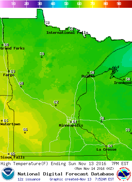
Our Sunday highs could range from the upper 40s over northeastern Minnesota to the mid 60s over the southwest.
Create a More Connected Minnesota
MPR News is your trusted resource for the news you need. With your support, MPR News brings accessible, courageous journalism and authentic conversation to everyone - free of paywalls and barriers. Your gift makes a difference.
Our average high temp this time of year is 43 degrees in the Twin Cities, but most of the metro area should see highs in the lower 60s.
A weak cold front moves through tonight, and highs on Monday will be in the 50s over central and southern Minnesota:

The Twin Cities area is likely to see highs in the 50s through this coming week.
Monday "Supermoon"
According to NASA, Monday's full moon will be bigger and brighter than a typical full moon:
The moon is a familiar sight in our sky, brightening dark nights and reminding us of space exploration, past and present. But the upcoming supermoon — on Monday, Nov. 14 — will be especially “super” because it’s the closest full moon to Earth since 1948. We won’t see another supermoon like this until 2034.
The moon’s orbit around Earth is slightly elliptical so sometimes it is closer and sometimes it’s farther away. When the moon is full as it makes its closest pass to Earth it is known as a supermoon. At perigree — the point at which the moon is closest to Earth — the moon can be as much as 14 percent closer to Earth than at apogee, when the moon is farthest from our planet. The full moon appears that much larger in diameter and because it is larger shines 30 percent more moonlight onto the Earth.
According to the United States Naval Observatory, the moon sets at 6:55 a.m. Monday and then rises again at 5:24 p.m. Central Standard Time.
Snow Friday night?
NOAA's Global Forecast System model shows a strong low pressure system over eastern South Dakota Friday morning:

If that happens, Friday will be a windy and rainy day for most of Minnesota.
The rain could change to wet snow Friday night into Saturday for parts of Minnesota, as the low pressure system tracks northeastward.
There is a lot of uncertainty about the track of the low:

We will keep you updated as we get closer to the weekend!
Programming note
You can hear my live weather updates on Minnesota Public Radio at 7:35 a.m. and 4:35 p.m. each Saturday and Sunday.