Showers at times, possibly a thunderstorm
Our weather is settling down a bit today, but some isolated strong to severe thunderstorms are still possible over southeastern Minnesota this afternoon and evening.
From southwestern through central Minnesota and the Twin Cities, occasional showers and an isolated thunderstorm are possible this afternoon and this evening. The best chance of thunderstorms will be near a stationary front over southeastern Minnesota.
The Storm Prediction Center of the National Weather Service shows a marginal risk of severe weather today and tonight over far southeastern Minnesota:

The National Weather Service North American Mesoscale Forecast System model shows the expected rain pattern from today through Sunday morning:
Create a More Connected Minnesota
MPR News is your trusted resource for the news you need. With your support, MPR News brings accessible, courageous journalism and authentic conversation to everyone - free of paywalls and barriers. Your gift makes a difference.
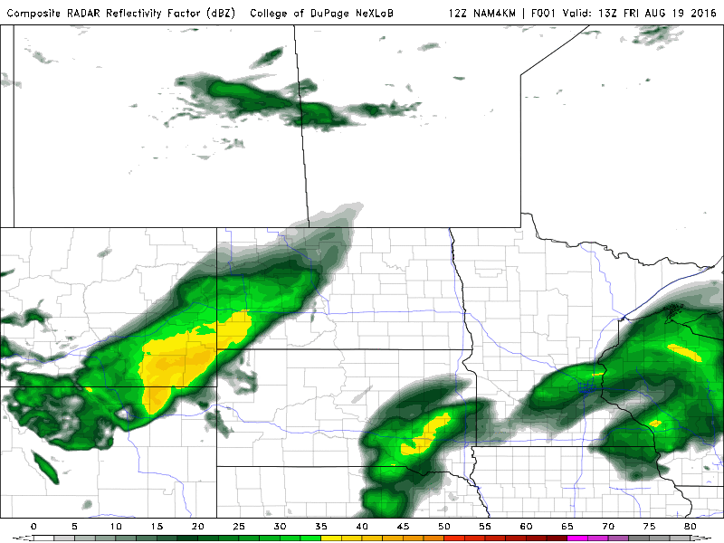
A low-pressure system will pass to our southeast tomorrow, bringing some showers to most of Minnesota and Wisconsin. Far northwestern Minnesota could have a dry Saturday. The final frames of the loop show a rain-free Sunday!
Cooler temps
Highs in the 70s are expected today:

A few spots in the Twin Cities could see upper 70s.
Saturday will be very cool, with mostly 60s:

A few spots in southern Minnesota could top 70. If we don’t reach 71 degrees in the Twin Cities tomorrow, it will be our coldest high temp in the metro area since June 1.
Mostly lower 70s are on tap for Sunday:

State Fair weather
Our Minnesota State Fair opens next Thursday. The opening day weather looks good at this point. The National Weather Service Global Forecast System model shows rain to our east at midday next Thursday, with a high-pressure system moving toward us:

The forecast for opening day at the Minnesota State Fair could change, but it looks like we'll have dry weather with highs somewhere in the 70s.
Severe weather reports
Here is a summary of severe weather reports from yesterday and early this morning, courtesy of the Twin Cities NWS:
PRELIMINARY LOCAL STORM REPORT...SUMMARY
NATIONAL WEATHER SERVICE TWIN CITIES/CHANHASSEN MN
928 AM CDT FRI AUG 19 2016
..TIME... ...EVENT... ...CITY LOCATION... ...LAT.LON...
..DATE... ....MAG.... ..COUNTY LOCATION..ST.. ...SOURCE....
..REMARKS..
0205 PM HAIL 4 SSE WANDA 44.26N 95.19W
08/18/2016 M1.00 INCH REDWOOD MN TRAINED SPOTTER
0220 PM TSTM WND GST 2 NNW SPRINGFIELD 44.26N 94.99W
08/18/2016 M53 MPH BROWN MN TRAINED SPOTTER
PRIVATE WEATHER STATION.
0225 PM TSTM WND DMG 5 SSE CLEMENTS 44.32N 95.01W
08/18/2016 REDWOOD MN BROADCAST MEDIA
BIG EVERGREENS SNAPPED OFF OR PUSHED OVER.
GARAGE WALL PEELED OFF. KLGR RADIO RELAYED.
0230 PM TSTM WND DMG 1 NE SPRINGFIELD 44.24N 94.96W
08/18/2016 BROWN MN TRAINED SPOTTER
TWO BOX CARS BLOWN OFF TRACK AT THE CO-OP.
0243 PM TSTM WND GST 3 SSE SLEEPY EYE 44.25N 94.71W
08/18/2016 M53 MPH BROWN MN PUBLIC
REPORTED AT 26227 200TH ST, SLEEPY EYE, MN
AIRPORT.
0305 PM TSTM WND GST 5 SSE SEARLES 44.17N 94.38W
08/18/2016 M69 MPH BROWN MN TRAINED SPOTTER
HOME WEATHER SENSOR MEASURED WIND GUST. ALSO
HAD TREE DAMAGE IN THE AREA, WITH POWER OUT
AS WELL. SPOTTER ALSO REPORTED SOME SOYBEANS
HAD BEEN FLATTENED IN NEARBY FIELDS.
0320 PM TSTM WND GST 3 NE MADELIA 44.08N 94.37W
08/18/2016 E64 MPH BLUE EARTH MN MESONET
MESONET STATION MADELIA 3 ENE /MN045/ ROAD
SIDE EQUIPMENT...STILL AWAITING COLLATERAL
DAMAGE REPORTS FOR CONFORMATION OF THIS
EVENT.
0320 PM TSTM WND DMG LAKE CRYSTAL 44.10N 94.22W
08/18/2016 BLUE EARTH MN LAW ENFORCEMENT
BRANCHES DOWN AND POWER OUT.
0330 PM TSTM WND DMG 1 S MANKATO 44.15N 93.99W
08/18/2016 BLUE EARTH MN BROADCAST MEDIA
LARGE TREE DOWN IN FRONT YARD. VIA SOCIAL
MEDIA.
0414 PM TSTM WND GST 2 WSW WASECA 44.07N 93.55W
08/18/2016 M59 MPH WASECA MN PUBLIC
REPORTED AT ACQ AIRPORT.
0155 AM TSTM WND DMG GLENCOE 44.77N 94.15W
08/19/2016 MCLEOD MN LAW ENFORCEMENT
LARGE TREES DOWN AND POWER LINES DOWN IN
GLENCOE.
0210 AM TSTM WND GST 2 WSW WACONIA 44.84N 93.82W
08/19/2016 M60 MPH CARVER MN MESONET
0235 AM TSTM WND DMG DELANO 45.04N 93.79W
08/19/2016 WRIGHT MN PUBLIC
HOME WINDOW BLOWN IN. TIME ESTIMATED BY
RADAR AND NWS EMPLOYEE.
0243 AM TSTM WND DMG LONG LAKE 44.99N 93.57W
08/19/2016 HENNEPIN MN TRAINED SPOTTER
FOUR INCH DIAMETER TREE LIMB SEVERED. TIME
ESTIMATED FROM RADAR.
0254 AM TSTM WND DMG ST. MICHAEL 45.21N 93.66W
08/19/2016 WRIGHT MN PUBLIC
TREES (APPROXIMATELY 20 FEET TALL), TOPPLED.
TIME ESTIMATED FROM RADAR.
0300 AM HAIL HASTINGS 44.73N 92.85W
08/19/2016 M0.88 INCH DAKOTA MN STORM CHASER
WINDS ESTIMATED AT 55 MPH.
0315 AM TSTM WND GST 5 E ELK RIVER 45.33N 93.47W
08/19/2016 M46 MPH ANOKA MN MESONET
0420 AM HAIL BLOOMER 45.10N 91.49W
08/19/2016 M0.75 INCH CHIPPEWA WI PUBLIC
One report that really caught my eye was from Springfield, Minn., in Brown county. At 2:30 p.m. yesterday, a trained severe weather spotter reported that two box cars were blown off track at the coop.
I'm glad that our forecast is looking quieter over the next few days!