‘Mega-rain’ biggest since Duluth flood, extreme heat next week
Forecasting is like looking out your windshield. Current weather is the sunroof. Climate is the rear view mirror.
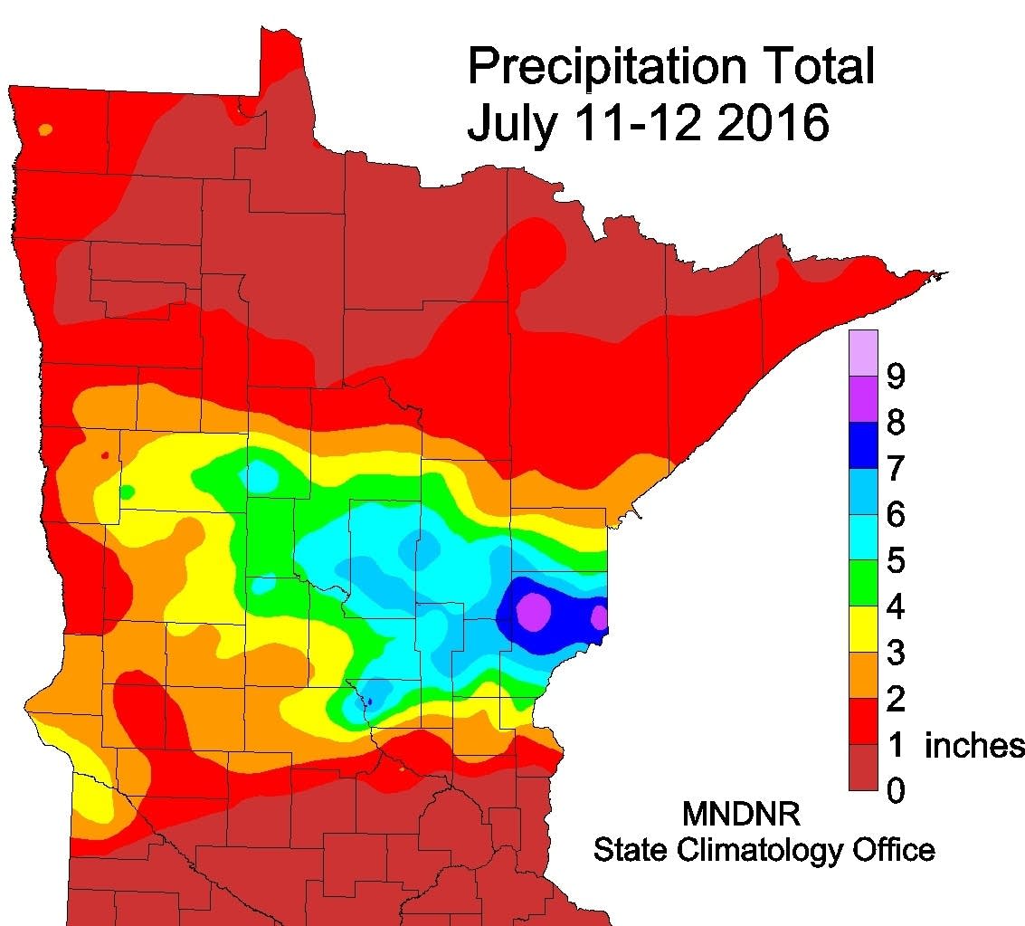
Minnesota's climate community is still crunching the numbers from Monday's 'mega-rain' event across central Minnesota. A mega-rain event means 6 or more inches of rain over a 1,000 square mile area. Turns out Monday's deluge was the biggest extreme rainfall event in Minnesota since the Duluth flood in 2012. And some of the same areas got hit again as tropical downpours 'trained' over the same areas again and again.

Pine County was ground-zero for the heaviest rainfall totals in Minnesota. Over 9" fell in some locations there. A huge swath of 6" to 9" covered central Minnesota including the Brainerd Lakes area.
Here's more on the magnitude of Monday's flood from the Minnesota Climate Working Group.
Create a More Connected Minnesota
MPR News is your trusted resource for the news you need. With your support, MPR News brings accessible, courageous journalism and authentic conversation to everyone - free of paywalls and barriers. Your gift makes a difference.
The largest flash flood since the June 19-20, 2012 event in northeast Minnesota struck some of the same areas on July 11-12, 2016. This time Pine County was hit especially hard. The highest two-day total found so far with this event was 9.34 inches at a DNR rain gauge volunteer site near Cloverton in eastern Pine County, near the Wisconsin border. The event was approximately 24 hours in duration, but spanned over the observer's observation time. Flooding rains also affected parts of Morrison, Aitkin, Cass, Crow Wing, Benton, Mille Lacs, Kanabec and Carlton Counties. Numerous roads were affected by water in the hardest hit counties. Southbound I-35 was closed for a time and Highway 61 was closed during the afternoon hours of the 12th. The area covered by six inches or more of rainfall exceeded 2,000 square miles, with at least 1,000 square miles in Pine County alone.
The main storm event was the finale of a stormy week across northern and central parts of the state, and formed as a warm front draped from west to east across central Minnesota. Dew point temperatures rose into the middle 70s across southern Minnesota, with a 25-degree air temperature difference over a short distance across the front. Thunderstorms developed along this sharp boundary in the early morning hours on the 11th and continued almost unabated in central Minnesota until the last shower crossed the Wisconsin border in the early hours of July 12th.
Aside from the heavy rain, at least three tornadoes affected Meeker and Stearns Counties, with EF-2 level tornado damage reported in both Watkins and Lichfield in Meeker County.
Mega-rains increasing in frequency
Dr. Mark Seeley sends word to the Weather Lab today that of the 13 recorded mega-rain events in Minnesota, 6 have occurred since 2002. Here's an early preview for Updraft readers from Mark's Weather Talk post this week. As always you can hear more from Mark exclusively on MPR News Friday morning in the 6 am hour on Morning Edition.

Topic: Storms again this week
Strong thunderstorms moved over portions of northern and central Minnesota during the past week, especially on July 11-12 (Mon-Tue). Rainfall totals from 5-7 inches occurred over portions of 10 central Minnesota counties, causing widespread flash flooding. Tornadoes caused some damage to homes, businesses, and farms in Meeker and Stearns Counties. Large hail was reported in 4 Minnesota Counties, the largest, 2.5 inch diameter near Mora.
According to the Minnesota State Climatology Office the storm on July 11-12 was the largest mega-rain event since the Duluth flood of June 19-20, 2012. A mega-rain event is classified as a six-inch rainfall that covers at least a 1000 square miles, with a central core value of at least 8 inches. There have been only 13 such storms documented in Minnesota history, but 6 of these have occurred since 2002. You can read more about this week’s storms at the MN State Climatology Office web site:
http://www.dnr.state.mn.us/climate/journal/160711_12_flood.html
The largest rainfall reported from the storm this week was 9.34 inches at Cloverton in Pine County. Several climate observers reported a new daily rainfall amount for July 11th, including:
7.51 Inches at Rice (Benton County)
6.38 inches at Brainerd airport (Crow Wing County)
6.36 inches at Bruno (Pine County)
5.50 inches at Moose Lake (Carlton County)
2.93 inches at Madison (Lac Qui Parle County)
2.63 inches at Saint Cloud (Stearns County)
2.27 inches at Duluth (St Louis County) tied record from 1914
2.00 inches at Wheaton (Traverse County)
With the large amount of rainfall, flood warnings were still being issued at the end of the week for parts of Pine, Aitkin, Kanabec, and Crow Wing Counties. Many areas of the state have already seen 5-7 inches of rainfall in July and the month is barely half over.
Rivers still rising
All that water is still running downstream. Downstream rivers include the Snake, Rum, Mississippi and St. Croix.

Some rivers showed rises of 10 to 14 feet this week. The St. Croix River near Grantsburg, WI appears to have set a new all time flood of record in the past 24 hours as it surged more than 10 feet this week.

That bubble of high water is heading downstream toward Stillwater where the river is expected to crest this weekend after a 9 foot rise.

Whiff of September
My dad used to talk about "good sleeping weather." Our hint of September lasts through Friday as Canadian high pressure slides in. Enjoy it while it lasts.
The next wave of T-storm rolls in late Saturday. It appears our recent weekend weather winning streak is about to come to a crashing halt.

Prolonged and dangerous heat wave?
The top national news story next week? probably the RNC in Cleveland. But a mega heat dome will likely generate national news next week. Minnesota gets in on the action next week. The Twin Cities should hit 90 as soon as next Wednesday.
Several days in the 90s in the metro, and 100 degrees seems likely for southwest Minnesota. Right now I'd say there's a 1 in 3 chance of hitting 100 in the Twin Cities the weekend of July 23-24.

This could be a prolonged heat event lasting 1-2 weeks. This upper air chart for the evening of July 28th suggests the core of the heat dome still over Minnesota and the central USA.

Stay tuned. If some of the model data I'm looking at verifies, this could go from an inconvenient, to potentially historic heat wave as late July unfolds.