Record warmth Saturday? Growing signs of an early spring
This may go down as the shortest winter on record in Minnesota.
Two Octobers. November roses at the Weather Lab. Minnesota's warmest December of the modern record.

Yes weather fans, the season formerly known as winter was more than fashionably late this season.
You can make a case that winter really began on Dec. 17. That's the first December day to produce a sub-freezing high temperature in the Twin Cities when the mercury managed 29 degrees. Looking ahead, we may be seeing the last gasps of winter in the next week. And the weather maps increasingly scream early spring.
Create a More Connected Minnesota
MPR News is your trusted resource for the news you need. With your support, MPR News brings accessible, courageous journalism and authentic conversation to everyone - free of paywalls and barriers. Your gift makes a difference.
Major league warm front
Here it comes. The next blast of unseasonably mild Pacific air in a winter filled with a parade of Pacific fronts. This one will feel like early April, as temperatures soar into the 50s behind the front Saturday.

Record highs Saturday?
How do you get record highs in late February?
The rare combination of no real snow cover, a due west wind over snow free ground, and sun intensity matching Oct. 15 by Saturday. I'm becoming increasingly convinced we will approach, and possibly smash the record high of 54 degrees at Minneapolis-St. Paul International Airport Saturday.
Don't be shocked to see 60 degrees in southwest Minnesota (and maybe the far west metro) Saturday afternoon. 50s as far north as Fargo? Fifty-four in the Twin Cities is the average high for April 8.

The European Centre for Medium-Range Weather Forecasts model continues to be even more aggressive with Saturday's hot front. The overnight European Centre run cranks out 59 degrees for the Twin Cities Saturday afternoon. That's probably a little high, but not out of the question.

Growing signs of an early spring?
Several factors seem to indicate that the odds of an early spring are growing.
Little or no snow cover in southern Minnesota.
Shallow frost layer in soils; just 7 inches frost depth in St. Paul.
Several days of 40+ degrees starting tomorrow with 50s Saturday.
More 50s to near 60 degrees around March 10th? (NOAA Global Forecast System data)
If we get to around March 10 with no snow cover, high winds and some rainfall ice on lakes in southern Minnesota could be close to going out. If current forecast model trends verify, I predict we'll challenge record early ice outs this spring, with many lakes in southern Minnesota ice free in March.
You can track ice out dates on your favorite lake at the Minnesota Department of Natural Resources site.

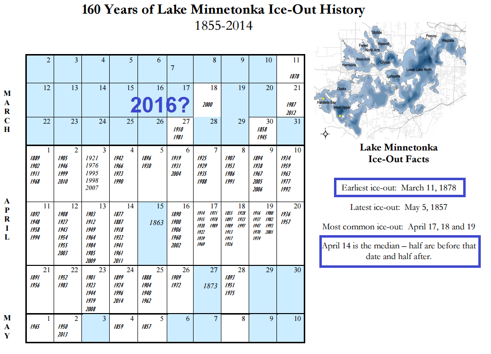
If I had to put money on bellwether Lake Minnetonka going out this spring, I'd probably pick the week surrounding March 15 at this point. That would be the second earliest ice out on record. The earliest is March 11.
A seven-month boating season this year? It could happen.

From the twitterverse
Rare February east coast severe outbreak. More than a dozen tornadoes with severe warnings up and down the east coast. Not your typical February weather pattern for Washington, D.C., and New York City.
D.C. and Virginia got hammered with this rare February severe outbreak.
This is by far the earliest tornado warning in the year for parts of Pennsylvania.
Unprecedented severe outbreak for Boston in February?
Meanwhile in baked Alaska:
Some alarming news about how climate change is affecting our oceans from Down Under.
Watching sea levels rise.