Putting Minnesota’s 2015 weather in perspective

Welcome to Minnesota, aka the Land of 10,000 Weather Extremes.
As the final weather numbers for 2015 roll in we begin to process the deeper context of the weather year that was.
Submitted for your approval:
Create a More Connected Minnesota
MPR News is your trusted resource for the news you need. With your support, MPR News brings accessible, courageous journalism and authentic conversation to everyone - free of paywalls and barriers. Your gift makes a difference.
2015 was the sixth warmest year on record in Minnesota.
2015 was the eighth warmest year on record in the Twin Cities.
Last fall was the second warmest in Minnesota history.
December came in as the third warmest in the Twin Cities.
The summer of 2015 was one of the most "glorious" in Minnesota history.

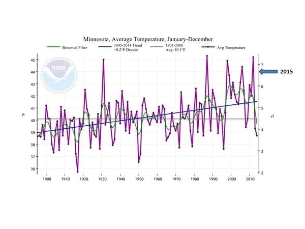
2015: Sixth warmest year on record for Minnesota
A surge of late warmth in 2015 boosted Minnesota's annual average temperature to the sixth warmest in state history. Most of Minnesota came in about 2 degrees warmer than average last year. Interestingly, if you compare 2015 to temperature averages of the late 1800s, Minnesota was about 5 degrees warmer. The pioneers would be envious.

Here's more perspective from my MPR colleague Mark Seeley in his most recent Weather Talk post.
Mean annual temperatures from around that state for 2015 ranged from 1.5 to 2.5F above average, marking the 6th warmest year in history back to 1895 (statewide annual mean temperature was 44.0°F). The warmest temperature reading was 99F at Madison (Lac Qui Parle County) on June 10th, the coldest reading was -43F at Cotton (St Louis County) on February 20th.
On a statewide basis, 2015 was wetter than normal, ranking 21st wettest since 1895. Many climate stations reported over 40 inches of precipitation for the year. Both Austin and Waseca had exceptionally wet years with approximately 45 inches of precipitation. Most snow fell at Isabella with 96.5 inches. The largest single day rainfall was 6.54 inches at Afton on July 6th.
Twin Cities: Eighth warmest year in 2015
The Twin Cities came in a little lower on the list of all-time-warmest years in 2015. Eighth place? Still a respectable top-10 finish.
El Nino plays a role?
The effects of the strongest maturing El Nino event since at least 1997-98 probably played a role in our late warmth in 2015. Strong El Nino events load the dice in favor of warm winters in Minnesota.

Here's a good depiction showing the late-season warm surge by month as El Nino kicked in last fall, from Greg Carbin at NOAA's Storm Prediction Center.
The good weather news? We got off easy on our heating bills this fall and early winter across Minnesota.
Top 5 weather events of 2015: Warmth, wind and smoke?
You know it was a good (quiet) weather year in Minnesota when the top three weather stories are essentially non-life-threatening events. The memorable Brainerd Lakes area supercell blow-down was the most damaging severe-weather event in 2015.
Here's a closer look at Minnesota's top five weather events of 2015 from the Minnesota Climate Working Group.

One of the more bizarre candidates originated from Canada in the form of smoke. There were smoky skies at various times in the summer of 2015, with the thickest smoke observed on July 6, 2015. Visibilities were reduced to a mile and a quarter in St. Cloud and two-and-a-half miles in the Twin Cities. The scent of smoke was in the air and a pall hung over the metro. All courtesy of a cold front bringing smoke from fires in Saskatchewan and northern Manitoba over 1,000 miles away.
#4 Straight Line Winds Wreak Havoc in the Brainerd Lakes Area: July 12, 2015
The most damaging severe storm event of the year came in the form of a line of severe thunderstorms that brought winds from 70 to 95 mph in an area just south of Wadena eastward to the Pillsbury State Forest where winds were in excess of 100mph in places. Significant damage was done to resorts on Gull and North Long Lake as well as the grandstand at the Brainerd International Raceway.
#3 The Non-Winter of 2015-2016 (so far)
If December were to end on the 28th, it would be the second warmest December in the Twin Cities at 31.4 degrees. Temperatures have also failed to drop to or below the zero mark in the Twin Cities. As a result there has been a delay in ice freeze-up on lakes and will likely be the second latest freeze up at Lake Waconia (1940-2014) and the third latest freeze up at Medicine Lake. (1955-2014) Open water was still being observed on Lake Minnetonka and White Bear Lake on the 27th, and many other lakes across the state are approaching their latest ice freeze-up dates.
#2 The Glorious Summer of 2015
Sometimes the weather just brings pleasant conditions, which is what happened for a good part of the summer of 2015. There was a dearth of 90 degree temperatures (only four compared to the average of 13). Prolonged dew point episodes were more or less kept in check, and days were pleasant enough to have the summer of 2015 finish the third glorious on record.
#1 2nd Warmest Autumn Statewide
Second warmest September-November in Minnesota back to 1895. Average statewide temperature was 49.5 degrees or 6.3 degrees above normal. It fell just short of the autumn of 1963 which was 49.7 degrees or 6.5 degrees above normal.
2016 outlook: Mild start overall?
As we ease into 2016 the continued effects of El Nino will likely keep us milder than average overall for the rest of winter. Next week's inbound Arctic outbreak reminds us that even in El Nino years, we still get occasional cold spikes.

The early look at February from NOAA's Climate Forecast System (CFS v2) favors milder-than-average temperatures in February across a good chunk of North America.

Stay tuned.