Winter storm warnings northwest, another messy metro mix
winter
noun win·ter \ˈwin-tər\
: the coldest season of the year that is after autumn and before spring
The season formerly known as winter is finally getting cranked up in western and northern Minnesota. The Twin Cities slogs through yet another messy snow to rainy mix as our latest unseasonably warm winter storm moves through.
Weather headlines:
Create a More Connected Minnesota
MPR News is your trusted resource for the news you need. With your support, MPR News brings accessible, courageous journalism and authentic conversation to everyone - free of paywalls and barriers. Your gift makes a difference.
Winter storm warnings expand to include all of of northwest Minnesota.
Winter weather advisories include Marshall, Willmar, St. Cloud, Brainerd, and northeast Minnesota
Wintry mix for Twin Cities metro once again, early AM snow to rain
Season's coldest air arrives Thursday night

The system
Behold. An actual winter storm sailing across Minnesota. Here's a look at the maps.

Snowfall projections
This will be a decent snow producer in the northwest half on Minnesota. It's just too warm again in the other half of Minnesota for significant accumulations. We enjoy a quick shot of snow early Wednesday morning in the metro, then precip trends toward rain once again. What are the chances of an inch in your back yard? Here's a look at the Twin Cities NWS new experimental probabilistic approach to forecasting winter snowfall totals.

Head northwest up I-94, you'll run into potentially plowable snow northwest of St. Cloud.

Full blown winter storm northwest
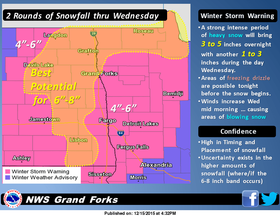
This is the real deal for the Red River Valley and most of northwest Minnesota, where winter storm warnings fly through Wednesday.

243 PM CST TUE DEC 15 2015
...WINTER STORM WARNING IN EFFECT FROM 6 PM THIS EVENING TO MIDNIGHT CST WEDNESDAY NIGHT...
THE NATIONAL WEATHER SERVICE IN GRAND FORKS HAS ISSUED A WINTER STORM WARNING FOR SNOW AND BLOWING SNOW...WHICH IS IN EFFECT FROM 6 PM THIS EVENING TO MIDNIGHT CST WEDNESDAY NIGHT. THE WINTER STORM WATCH IS NO LONGER IN EFFECT.
* TIMING...THERE COULD BE SOME FREEZING DRIZZLE THROUGH THIS EVENING. SNOW WILL DEVELOP SHORTLY AFTER SUNSET AND BECOME HEAVY AT TIMES OVERNIGHT. LIGHT SNOW WILL CONTINUE AT TIMES WEDNESDAY WITH BLOWING SNOW IN THE RED RIVER VALLEY WEDNESDAY AFTERNOON
INTO WEDNESDAY NIGHT.
* PRECIPITATION RATES...THE HEAVIEST SNOWFALL RATES WILL OCCUR BETWEEN MIDNIGHT AND 6 AM WEDNESDAY.
* SNOW ACCUMULATIONS...TOTAL SNOW ACCUMULATIONS OF 5 TO 7 INCHES ARE EXPECTED.
* WINDS / VISIBILITIES...LOOK FOR SIGNIFICANT REDUCTIONS IN VISIBILITY AT TIMES IN HEAVIER SNOW BANDS TONIGHT AND BLOWING SNOW WEDNESDAY AFTERNOON AND EVENING.
* IMPACTS...PLAN ON DIFFICULT DRIVING CONDITIONS...INCLUDING DURING THE MORNING COMMUTE ON WEDNESDAY.
Further south, the view from the Aberdeen NWS. Heavy snows in central South Dakota leak into the nook in far western Minnesota.

In northern Minnesota, a good overview from the Duluth NWS. News you can use.

Season's coldest air in tow
We finally get a decent shot of cold air behind this system. Temps moderate again by Sunday.

White Christmas a lock up north, still iffy for metro
This snowfall pretty much locks in a white Christmas for the northwest half of Minnesota. In case you were wondering, here a look at the historical chances for a white Christmas across Minnesota. The Twin Cities sports a 72% chance for a white Christmas historically.

Here's more on the odds for winter white on Christmas morning from the Minnesota Climate Working Group.
Will we have a white Christmas? It's an age-old question that occurs to almost everyone this time of year. The chances of having a white Christmas vary even here in Minnesota. Having a white Christmas is loosely defined as having 1 inch of snow on the ground on Christmas Day. The snow depth at most sites is measured once a day, usually in the morning. The best chances of having a white Christmas is almost guaranteed in the Boundary Waters Canoe Area and a good part of the Arrowhead. The chances decrease to the south and west and the best chance for a "brown" Christmas is in far southwest Minnesota where chances are a little better than 60%. Northern Minnesota is one of the few non-alpine climates in the US where a white Christmas is almost a sure bet (U.S. White Christmas Probabilities).
In 116 years of snow depth measurements in Twin Cities, a white Christmas happens about 72% of the time. From 1899 to 2014 there have been 33 years with either a "zero" or a "trace." The last time the Twin Cities has seen a brown Christmas was 2014. The deepest snow cover on December 25th was in 1983 with a hefty 20 inches. It was also a very cold Christmas in 1983, with the high temperature of one (1) degree F. It was not the coldest Christmas Day in the Twin Cities. That dubious award goes to 1996 with a "high" temperature of 9 below zero F. The warmest Christmas Day in the Twin Cities was 51 degrees in 1922. There was not a white Christmas that year. In fact, the Minneapolis Weather Bureau log book for that day states that the day felt "spring like."
The forecast models still hint at at southwest flow aloft and a chance for passing ripples that could still eek out a coating of winter white in the metro around Christmas eve. I'm still not ready to write off a white Christmas for the metro just yet.

Stay tuned.