Waves of rain, El Nino pushes into record territory
Ducky.
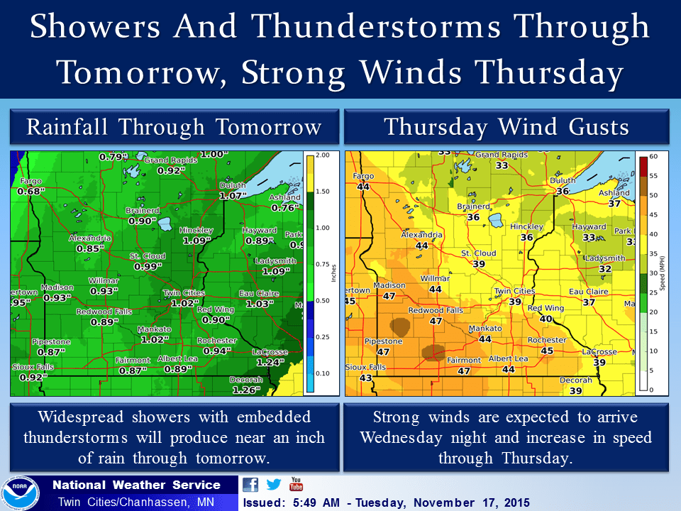
That's the highly technical weather term I used to describe today's weather across Minnesota. Waves of rain continue to roll northward through Minnesota today.
Rainfall totals pass the 1 inch mark across the Twin Cities today, on the way to 2 inches in some areas by tomorrow. Throw in a little thunder and you've got another unusually mild late fall season storm system for now until frigid winds blow in on the system's backside Wednesday night and Thursday.
It could be worse, It could be all snow. Just ask Denver. Or western Kansas. Blizzard warnings are flying today.
Create a More Connected Minnesota
MPR News is your trusted resource for the news you need. With your support, MPR News brings accessible, courageous journalism and authentic conversation to everyone - free of paywalls and barriers. Your gift makes a difference.

INCLUDING THE CITIES OF...CASTLE ROCK...ELBERT...FONDIS...KIOWA...LARKSPUR
352 AM MST TUE NOV 17 2015
...BLIZZARD WARNING NOW IN EFFECT UNTIL 11 AM MST THIS MORNING...
* TIMING...HEAVY SNOW WILL CONTINUE THROUGH MID MORNING...THEN DIMINISH.
* SNOW ACCUMULATIONS...ADDITIONAL ACCUMULATIONS OF 4 TO 7 INCHES TODAY...HEAVIEST IN ELBERT COUNTY. THIS WILL GIVE STORM TOTAL ACCUMULATIONS OF 14 TO 24 INCHES.
* WIND/VISIBILITY...NORTHERLY WINDS AT 25 TO 40 MPH WITH GUSTS UP TO 60 MPH IN ELBERT COUNTY THIS MORNING. WIDESPREAD WHITEOUT CONDITIONS WILL OCCUR. WINDS WILL DIMINISH TO 20 TO 30 MPH THIS AFTERNOON IMPROVED VISIBILITIES BUT SOME DRIFTING CONTINUING.
* IMPACTS...DO NOT TRAVEL UNLESS ABSOLUTELY NECESSARY...YOU MAY BECOME STRANDED. HEAVY SNOW AND DRIFTING SNOW WILL BLOCK NUMEROUS ROADS. WIDESPREAD WHITEOUT CONDITIONS CAN BE EXPECTED.
Powerhouse low
It's another powerful and rapidly deepening mid-November low pressure system. Watch as the low winds up and tracks almost due north into Hudson Bay the next 48 hours. Behind it? Colder winds that turns rain to snow across northern Minnesota.

The impressive system is pumping a solid plume of tropical moisture north from the Gulf of Mexico right into Minnesota.

Here's a closer look at rainfall totals with the system: 1 to 2 inches across the Upper Midwest with several inches in the lower Mississippi Valley.

Snow up north
The westerly track to this system means Minnesota is mostly on the milder side of this system. That means mostly rain. As colder air rushes in behind the storm, rain changes to snow tomorrow night.
We could see a few flakes as far south as the Twin Cities. Accumulating snow looks likely for northern Minnesota by Thursday morning. A swath of 2 to 5 inches-plus north of a Bemidji-Hibbing-Grand Marais line? Yes folks, it's getting closer.

Solid freeze ahead
The season's coldest air pours in behind the system Thursday. Temps mostly hover near or below freezing from Thursday into Sunday morning. This will be the first solid freeze of the season.


Super El Nino sets first records
Many of us El Nino watchers have been expecting this. This week El Nino set the first of what could be several records by posting weekly Pacific SST departures of +3.0C (+5.4F) in the benchmark Nino 3.4 region. The +3.0 C reading passes the highest weekly reading of +2.8C recorded in the record 1997-98 El Nino event.
The 5.4 degrees Fahrenheit above average ocean water for the week centered on Nov. 11 surpasses the highest reading in the 1997-98 event, but more weeks of record readings may be needed to declare this the king of El Ninos.

More comparisons will be made as the current El Nino peaks in the coming weeks. The event already rivals the massive 1982-83 and 1997-98 episodes.
The LA Times has more on the magnitude of this week's news.
Temperatures in a key location of the Pacific Ocean are now far hotter than normal than ever were in the record 1997 El Niño.
Some scientists say the readings show that this year’s El Niño could be among the most powerful on record -- and even topple the 1997 El Niño from its pedestal.
“This thing is still growing and it’s definitely warmer than it was in 1997,” said Bill Patzert, climatologist with NASA’s Jet Propulsion Laboratory in La Cañada Flintridge. As far as the temperature readings go, "it’s now bypassed the previous champ of the modern satellite era -- the 1997 El Niño has just been toppled by 2015.”
Daniel Swain, a climate scientist at Stanford University, called the temperature reading significant. It is the highest such weekly temperature above the average in 25 years of modern record keeping in this key region of the Pacific Ocean west of Peru.
“This is a very impressive number,” Swain said, adding that data suggest that this El Niño is still warming up. “It does look like it’s possible that there’s still additional warming” to come.
“We’re definitely in the top tier of El Niño events,” Swain said.
Temperatures in this key area of the Pacific Ocean rose to 5.4 degrees Fahrenheit above average for the week of Nov. 11. That exceeds the highest comparable reading for the most powerful El Niño on record, when temperatures rose 5 degrees Fahrenheit above the average the week of Thanksgiving in 1997.