Frosty then warm again, Wednesday rain
We wake to seemingly rare autumn frost this weekend around Minnesota. Take a selfie. The frosty landscape doesn't last long. Our parade of warm fronts resumes Sunday. November roses at the Huttner Weather Lab?
Priceless.
Just how unusual is our rose-blooming November warmth in the Twin Cities? Here's a quick clip from Dr. Mark Seeley's weekly Weather Talk blog on our rare November warmth.

Create a More Connected Minnesota
MPR News is your trusted resource for the news you need. With your support, MPR News brings accessible, courageous journalism and authentic conversation to everyone - free of paywalls and barriers. Your gift makes a difference.
-Very warm conditions prevailed around the state over the first several days of November. At least 15 climate stations have reported a daytime high temperature this month of 70°F or higher, topped by 78°F at Madison (Lac Qui Parle County) on the 3rd. The warmth reached as far north as Hibbing where it reached 64°F on the 3rd, while some western Minnesota observers (Canby, Appleton, and Madison) reported three consecutive afternoons with highs in the 70s F this first week of November which last happened in 1999 and 1975.
Frosty weekend mornings
Deer hunters in orange layers is the fashion trend this weekend across Minnesota.
Frosty mornings give way to milder afternoons. MSP Airport has recorded just one day below 32 degrees so far this fall with 31 degrees on the morning of October 17th. Temps bottom out below freezing across a good chunk of the Upper Midwest this weekend. The inner metro core approaches 32 degrees again with widespread frost a good bet.

2015 Minnesota Deer Opener: Dry with light winds
Some light snow fell across far northern Minnesota Thursday night. Most of that will be hard to find this weekend with daytime temps above freezing. Most of Minnesota will not have tracking snow for hunters this weekend.

Here's a closer look at hour by hour conditions for the Minnesota Deer Opener this weekend. Light winds Saturday could be favorable. A steadier south breeze blows in Sunday.
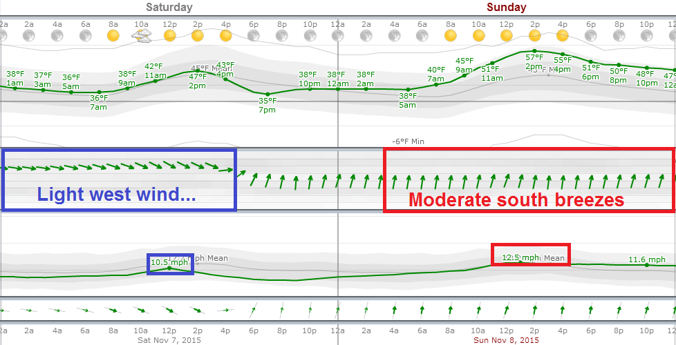
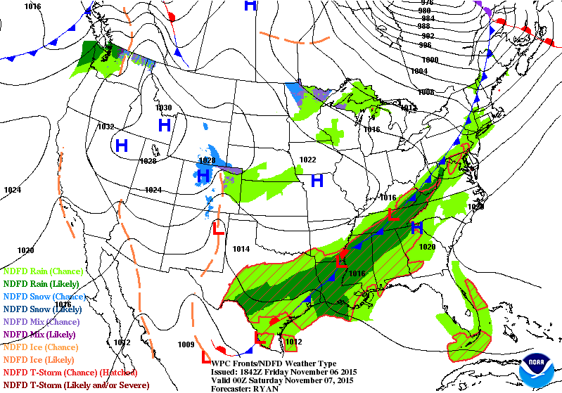
To the maps. Our seasonably cool high pressure cell slides east by Sunday and opens the door to milder southerly breezes. The next rain/snow system gathers in the Rockies bringing some welcome moisture to northern California.
Mild bias continues for now
This fall has featured a notable lack of cold air intrusions into the US. The reason? A persistent "zonal" westerly wind flow blowing in mild air masses from the Pacific instead of the Arctic Circle. The Polar Front Jet Stream is stuck in Canada, still running well north of the mean position for early November. An early symptom of the strongest El Nino since 1997-98? Probably.

Our Pacific breezes return Sunday, and blow into next week with temperatures running a good 10 degrees warmer than average from Sunday through next Tuesday. I won't be shocked to see 60 degrees nudge the southwest metro Sunday afternoon.
Here's a closer look at the next week according to the Euro model.

Rain next week?
Here's a dirty little secret in the cooperate weather business. Many firms take NOAA/Euro model data and dress it up, then stamp their own product branding on the graphic. "Internal" models? Maybe. More likely some massaging of NOAA derived data, that's usually not much (any) better than what NOAA has. No magic rooms full of racks with the latest Cray supercomputers crunching their own raw numbers.
The Euro and US models are still having a hard time pinpointing the track and temperature profile of next week's inbound Midwest storm system. The notion of a deepening storm is gaining strength. The truth about storms 5 days out? The precise storm track and temperature profile in the lowest mile of the atmosphere (precip types) are still uncertain within the limits of the science of meteorology.
With that disclosure, the latest GFS and Euro trends spin up a strong storm favoring a southeast track toward Chicago.

First significant snow in sight?
Peer out into the murky crystal weather ball even further and we might see a mirage that could be the first real significant snowfall of the season for some part of Minnesota. Here's the GFS notion of a potential snow maker crossing Minnesota around November 18-19.

The digital output features moisture and 850 millibar temps (about 5,000 feet above ground) sub-zero C, cold enough for snow.

This can and will probably change. But mid-November is a climatologically favored window for our first significant snowfall In Minnesota. The average date of the first 1" snowfall in the Twin Cities?
November 18.

Winter Hazard Awareness Week in Minnesota: November 9th-13th
Yes, this is a good time to get the snow stakes in the driveway and brush up on your winter weather awareness skills. Here's what you need to know courtesy of the Twin Cities NWS.
Winter Weather Preparations
Keep ahead of the winter storm by listening for the latest weather statements, watches and warnings.
Your vehicle should also be ready. Get it winterized, before the onset of winter weather.
Be equipped for the worst. Carry a winter survival kit in your car, especially when traveling in rural or open areas. Try to travel with others.
When Driving
Yield to snowplows, and give them plenty of room to operate.
If your vehicle becomes stranded, stay with it until help arrives.
Do not try to walk for help during a blizzard, you could easily become lost in the whiteout conditions.
Outdoor Activities
If you will be outside during storms or extreme cold, dress in layered clothing and avoid overexertion.
Do not kill yourself shoveling snow. Shoveling is very hard work and may induce a heart attack.
If you will be snowmobiling, avoid alcohol. Most snowmobile deaths are alcohol related. Take a snowmobile course offered by the DNR or check with your snowmobile dealer.
Every year, there are fatalities in Minnesota when people fall through thin ice.
Home Safety
Heating fires are a major cause of residential fires in Minnesota. Turn off portable heating devices when you are away from home or retire for the evening. Have your fireplace and chimney professionally inspected before winter.
Carbon Monoxide is most likely to accumulate inside homes during winter. Check your heating systems and ensure your home has proper ventilation. Install a UL listed Carbon Monoxide detector that sounds an alarm.

70 years since Armistice Day Blizzard
It was the blizzard of the century. At least until the Halloween Mega Storm of 1991. The difference in 1940? No satellites, Doppler or advanced weather forecast modeling capability to warn vulnerable duck hunters and others killed by the sudden blizzard. Here's more from the Twin Cities NWS.
This year is the 75th anniversary of what many consider Minnesota's worst blizzard of the 20th Century. The Armistice Day Blizzard struck the region on November 11, 1940. The weather was relatively benign the morning of the 11th, and many people were outdoors, taking advantage of the nice mild weather. The forecast issued by the U.S. Weather Bureau in Chicago (there was no forecast office in the Twin Cities at the time) was for colder temperatures and a few flurries. Few people were prepared for what was to come. The storm started with rain, but it quickly turned to snow. By the time the blizzard tapered off on the 12th, the Twin Cities had received 16.7 inches of snow, Collegeville 26.6 inches, and 20-foot drifts were reported near Willmar. In all, 49 Minnesotans lost their lives in this storm, many of them hunters who were trapped by the sudden turn of events. There were about 150 deaths across the region.
Detailed retrospective from NWS La Crosse
[image]
40 years since Edmund Fitzgerald went down
The Ides of November are notoriously bad for storms in Minnesota. It's hard to believe it's been 40 years since the Edmund Fitzgerald went down on that cold stormy November 10, 1975. Here's more on the activities this weekend at the Lake Superior Maritime Museum in Duluth.
Here's an expert form a piece I wrote on the 35th anniversary of the sinking of the Fitz.
Would today’s forecasts save The Edmund Fitzgerald?
Paul Huttner November 10, 2010, 8:30 AM
I’ll never forget the wind on November 10, 1975. I remember the howling winds in the Twin Cities whistling through the trees. When I heard TV news legend Dave Moore on WCCO-TV tell us that the Edmund Fitzgerald had gone down in Lake Superior, I felt the coldest chill of my life go down the back of my neck. Our family had recently circled Lake Superior on a vacation, and I remember thinking about the horror of being in that storm on that lake on a dark November night.
35 years ago today that the Fitz went down. Looking back, there were several weather scenarios that could have saved the Fitz. The Fitz could have left 6 hours earlier, or stayed in port another 48 hours. They could have taken a shorter, more southerly route and possibly made Whitefish Bay before the height of the storm. If weather forecasters in 1975 had better data, they could have forecast the intense and rapid deepening of the storm system that would produce hurricane force winds and gigantic waves that sunk the Fitz.

Exxon Mobil Investigated for Possible Climate Change Lies by New York Attorney General
And so it begins.
What did Exxon and other oil and gas companies know about their products and climate change and when did they know it? Here's more from the New York Times on what is surely the first of many inquires and potential lawsuits over what big oil knew about how it's product would change earth's climate.
The New York attorney general has begun an investigation of Exxon Mobil to determine whether the company lied to the public about the risks of climate change or to investors about how such risks might hurt the oil business.
According to people with knowledge of the investigation, Attorney General Eric T. Schneiderman issued a subpoena Wednesday evening to Exxon Mobil, demanding extensive financial records, emails and other documents.
The investigation focuses on whether statements the company made to investors about climate risks as recently as this year were consistent with the company’s own long-running scientific research.
The people said the inquiry would include a period of at least a decade during which Exxon Mobil funded outside groups that sought to undermine climate science, even as its in-house scientists were outlining the potential consequences — and uncertainties — to company executives.
Kenneth P. Cohen, vice president for public affairs at Exxon Mobil, said on Thursday that the company had received the subpoena and was still deciding how to respond.