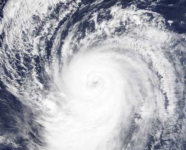
Tropics gone wild: Record tropical cyclone numbers in 2015
It's been a relatively quiet Atlantic hurricane season. Don't tell that to the Pacific.
The 2015 tropical cyclone season has reached record levels both for numbers and intensity of storms. We're now up to 20 Category 4 or higher tropical cyclones in 2015.
The latest superstorm to reach land is Koppu. The Philippines is reeling under the slow moving storm, which has already killed at least 12 and dumped more than 30 inches of rain in some spots.

Weather Underground has more on Koppu.
Create a More Connected Minnesota
MPR News is your trusted resource for the news you need. With your support, MPR News brings accessible, courageous journalism and authentic conversation to everyone - free of paywalls and barriers. Your gift makes a difference.
Extreme rainfall and flooding remain the main threat from Koppu. Steering currents have collapsed, and the typhoon will move very slowly to the northeast at less than 5 mph over northern Luzon for the next 2 - 4 days. Although Koppu will continue to deteriorate as its center remains over or near land, its broad, strong circulation will keep pulling deep moisture into the island, where upslope flow against higher terrain will squeeze out mammoth amounts of rain. Even a tropical depression can produce enormous rains if it’s moving slowly, especially when positioned near high terrain, and Koppu should maintain at least tropical storm strength the next two days. At a minimum, we can expect widespread storm totals of one to two feet of rain across much of northern Luzon. Multi-day rainfall totals of over two feet will result in widespread flooding and mudslides, and major agricultural damage can be expected as well. It appears the heaviest rains will stay north of the Philippines' most heavily populated region--the capital of Manila--but Koppu could still end up as one of the top-five most costly natural disasters in Philippine history.
Torrential rains in excess of 20" have already hit the city of Baguio, a regional center with about 300,000 residents that’s popular among visitors for its relatively cool climate. Located at an elevation of roughly 5000 feet, but less than 20 miles from Luzon’s west coast, Baguio is highly vulnerable to moist westerly winds being forced upslope. A typhoon in July 1911 dumped more than 2,200 millimeters (87 inches) of rain on the city in less than four days. In September 2015, Typhoon Goni brought more than 700 millimeters (28 inches) of rain to Baguio, even without making a direct hit on the Philippines, as noted by weather.com. Baguio received 6.34" of rain from Koppu in the 24 hours ending at 00 UTC October 19, 2015, then another 15.94" in the twelve hours ending at 12 UTC (8 am EDT) Monday. Another 11.14" fell in the six hours ending at 18 UTC, for a 42-hour rainfall total of 33.42" (849 mm.) Monday morning rainfall forecasts from the HWRF model were projecting another 1 - 2 feet of rain over western Luzon Island from Koppu.
For reference, below are the global and hemisphere records for heaviest rainfall observed in various time periods, as certified by the World Meteorological Organization and archived by Arizona State University.
24 hours: 1.825m (71.8"), January 7-8, 1966, Foc-Foc, La Réunion
48 hours: 2.493m (98.15"), June 15-16, 1995, Cherrapunji, India
72 hours: 3.930m (154.72"), February 24-26, 2007, Cratère Commerson, La Réunion
96 hours: 4.936m (194.33"), February 24-27, 2007, Cratère Commerson, La Réunion

Typhoon Champi headed towards Iwo Jima
The Pacific’s relentless tropical season of 2015 continues to amaze. On Sunday, Super Typhoon Champi became the Northern Hemisphere's record-setting twentieth Category 4 or stronger tropical cyclone of 2015 (previous record: eighteen in 2004, according to wunderblogger Dr. Phil Klotzbach.) Only one of those twenty Category 4 and 5 storms--Hurricane Joaquin--came from the Atlantic.
The numbers are eye-opening. It's been a remarkable, and likely El Niño-fueled tropical cyclone season. Again, more from Weather Underground.
Eastern Pacific's Hurricane Olaf sets a new record
Hurricane Olaf intensified into a major Category 3 hurricane on Monday at 11 am EDT in the waters about 1350 miles east-southeast of Hawaii, becoming the tenth hurricane and eighth major hurricane of this very busy Eastern Pacific hurricane season. Olaf became a major hurricane unusually far to the south--at 9.9°N latitude, making it the most southerly major hurricane ever observed in the Eastern Pacific since reliable records began in 1971. This year now ties with 2014 and 1992 for the most number of major Eastern Pacific major hurricanes (east of 140°W) in a season--eight. An average Eastern Pacific hurricane season sees 15 named storms, 8 hurricanes, and 3 intense hurricanes, and we have already had 15 named storms, 10 hurricanes, and 8 intense hurricanes so far in 2015. This is the second consecutive year with unusually heavy activity in the Eastern Pacific--in 2014, the basin had 20 named storms, 13 hurricanes, and 8 intense hurricanes, making it the busiest season since 1992, which set records for total number of named storms (24), hurricanes (14), and intense hurricanes (8). It has also been a hyperactive year for hurricanes in the Central Pacific, between 140°W and 180°W. So far in 2015, eight named storms have formed in the Central Pacific, setting a new record for tropical cyclone activity in that basin. According to wunderblogger Dr. Phil Klotzbach, prior to 2015, the previous record for named storms in the North Central Pacific for an entire season was four, set in 1982. This year's record activity in both the Eastern Pacific and Central Pacific has been due to unusually low wind shear and record-warm ocean temperatures caused by the strong El Niño event underway.
[image]