70s Monday, mild bias into November?
It looks like a long sweet fall in Minnesota.
The first freeze of the year blanketed the inner metro core this weekend. It may also be the last freeze for another two weeks. Our winds turn southerly once again next week, as milder breezes blow in and boost temperatures above seasonal norms. The longer range maps favor another mild temperature bias for most of the last two weeks of October.
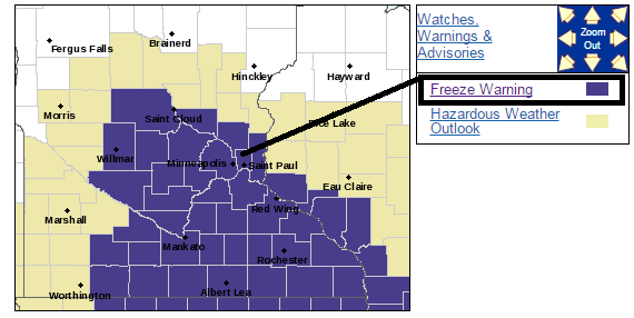
First, freeze warnings and the season's killing frost for the Twin Cities and most of southern Minnesota.
Create a More Connected Minnesota
MPR News is your trusted resource for the news you need. With your support, MPR News brings accessible, courageous journalism and authentic conversation to everyone - free of paywalls and barriers. Your gift makes a difference.
INCLUDING THE CITIES OF...ST. CLOUD...ELK RIVER...WILLMAR...LITCHFIELD...MONTICELLO...MINNEAPOLIS...BLAINE...ST. PAUL... STILLWATER...OLIVIA...HUTCHINSON...GAYLORD...CHASKA...SHAKOPEE... HASTINGS...NEW ULM...ST. PETER...LE SUEUR...FARIBAULT... RED WING...ST. JAMES...MANKATO...WASECA...OWATONNA...FAIRMONT...BLUE EARTH...ALBERT LEA...PRESCOTT...DURAND
212 PM CDT FRI OCT 16 2015
...FREEZE WARNING REMAINS IN EFFECT FROM 10 PM THIS EVENING TO 9 AM CDT SATURDAY...
* TEMPERATURE...20 TO 30.
* IMPACTS...UNPROTECTED PLANTS WILL BE KILLED.
The deep freeze extends deep into the Midwest Saturday morning. Temperatures push the freezing mark well into Illinois.

Frost and freeze warnings extend deep into the Ohio Valley.

Brief cold snap
This weekend's cold snap will be brief. Southerly winds begin to turn the temperature tide as soon as Sunday afternoon. High pressure slides east and opens the back door to warmer breezes.

By Monday, late summer like warmth returns to the Upper Midwest. Your local bank thermometer flashes 70 or better once again by Monday afternoon.

Here's a more detailed breakdown of the week ahead. Note the lack of freezing temps after Saturday.

Mild late October?
Here are the specific, but still outer edge of forecast confidence numbers for the Twin Cities through the end of October. More 70s ahead?

Mild into November?
The longer range maps hint at a few more spurts of unseasonable warmth into late October. In fact the National Oceanic and Atmospheric Administration's experimental three week outlook favors milder than average temps overall into early November.
The first signs of an El Nino tempered winter? Possibly.

Stay tuned.
Winter Travel Impact Index: Gauging winter commute 'hassle factor'
Starting this winter, the Twin Cities NWS will combine forecast data with analyzed road conditions to create a scale for likely commute times and accident rates. It's called the Winter Travel Impact Index. The index runs for 1-5, and will forecast commute times and accidents compared to average. A 'Category 5' commute in big snow around the metro?
I like this experimental idea a lot.
NOAA: 40 years of geostationary satellite data
The one weather tool I can't see us doing without? Real time high resolution images form 22-thousand miles up. It's been 40 years since the first NOAA "geostationary" satellite began beaming back images from space. Here's more from NOAA.
Yes, those early images revolutionized weather forecasts. The ability to see hurricanes a thousand miles from any land mass? Priceless.
Advances in imaging capability continue to produce vast improvements in capability today. Look how far we've come in 40 years.