Cooler Tuesday, Minneapolis #2 on Climate Disruption Index
Breathing easier
I spent a week in high school and a semester abroad in college. In Germany, the natives refer to humid air masses as feeling "close." That's one weather word that translates well from the original German to English. Sunday's dew point of 76 in the Twin Cities? More like "suffocating."
We catch a break from the heat and humidity across Minnesota for the next 48 to 72 hours. Temporarily fresher breezes blow from Canada as high pressure noses south. Tuesday night into Wednesday morning you'll be tempted to sleep with the windows wide open as dew points plunge into the 50s. By Wednesday night we turn our weather eyes back to the west as another developing warm front pushes scattered storms into Minnesota again. The early read on Thursday morning includes the potential for another shot of heavy rains.

Meteograms give us a quick look at multiple forecast details. For those in a hurry, it's a great way to gauge forecast weather conditions for your personal time frame. The big takeaways from the European Model data below? Dew points drop into the comfy range Tuesday night and Wednesday morning. Stifling heat and humidity return by the weekend as another tropical air mass surges north.
Create a More Connected Minnesota
MPR News is your trusted resource for the news you need. With your support, MPR News brings accessible, courageous journalism and authentic conversation to everyone - free of paywalls and barriers. Your gift makes a difference.

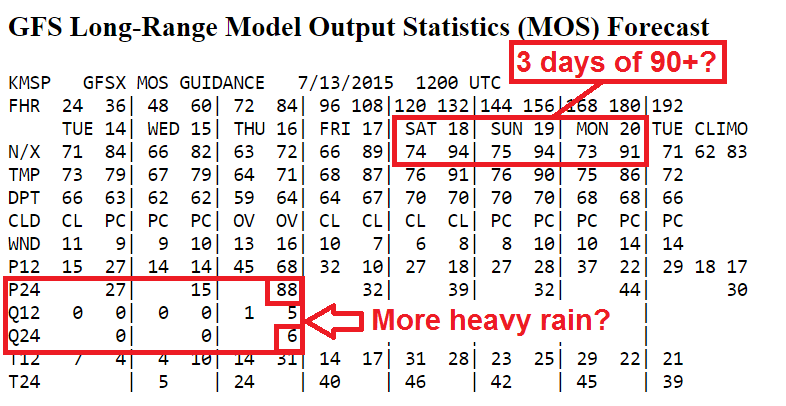
Yes the Euro may be too aggressive cranking out 98 degrees Saturday. Throw in another surge of dew points hitting 77 degrees and that calculates to an unthinkable heat index of 114 Saturday afternoon.

But NOAA's GFS runs are not far behind with 94 Saturday and Sunday afternoon and three days above 90 degrees Saturday through Monday. The GFS also hints at the potential for another shot of morning thunderstorms with heavy rain Thursday morning.
Speaking of heavy rainfall, Sunday nights bowing storm echo raced all the way southeast through Madison, Chicago, Indy and Cincy. It may reach the definition of a Derecho according to SPC's Greg Carbin.
Hopefully we can avoid another inbound smoke front courtesy of our Canadian neighbors to the north. An elevated smoke plume still casts a thin veil over Minnesota. Here's NOAA's Hazard Mapping System Fire and Smoke Product.

Super El Niño gains strength
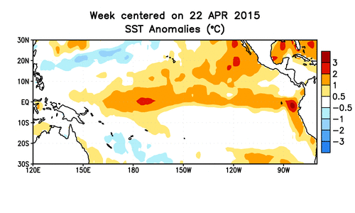
Call it what you want, this year's super-charged El Niño is still showing signs of heading toward record event territory. An intense blob of warmth is growing off the west coast of South America where tropical Pacific sea surface temperature's are pushing an incredible +3 degrees Celsius.
The early benchmarks from this year's El Niño event are rivaling the record 1997-98 monster El Niño event. Many experts including NOAA urge caution in reading the tea leaves from week to week, but the numbers are eye-opening.
Slate's Eric Holthaus has an interesting look at how this El Niño is opening eyes and getting help from the feedback look of an intense Pacific typhoon season.
Here’s how it works: The El Niño weather pattern is a joint effort between the ocean and the atmosphere, and this week’s surge showcases the linkage.
El Niño means the tropical Pacific is warmer than normal, which improves the chances that typhoons will form. This week, a series of typhoons on both sides of the equator are helping to reinforce a big burst of westerly winds along the equator. These westerly wind bursts are a hallmark of El Niño, and help push subsurface warm water toward the coast of South America. If enough warm water butts up against Peru, the normal cold water ocean current there can get shut off, exacerbating the pattern.
Exactly how this all gets kicked off is an area of active research, but it’s clear that big El Niños need deviant trade winds to maintain the feedback loop. During especially strong El Niños, like this year’s promises to be, the trade winds can sometimes reverse direction—and this week’s off-the-charts wind surge is at record-strengthfor so early in an El Niño event. Since all this takes place in the tropical Pacific Ocean—the planet’s biggest bathtub—a fully mature El Niño has the power to shift rainfall odds worldwide and boost global temperatures. That’s exactly what’s happening this year.
For Minnesota, the smart money is on a (much?) milder than average winter next year. Snowfall in El Niño winter's can vary greatly. It is still cold enough for snow in mid-winter even if temperatures are 10 degrees warmer than average. The massive back-to-back snow events in January 1983 were during an El Niño event.
Stay tuned.
Twin Cities: High on Climate Disruption Index
Think climate change impacts coastal cities most? Think again. According to The Weather Channel's new Climate Disruption Index, the Twin Cities rank among the cities most affected by climate changes. Minneapolis comes in at No. 2, behind only New Orleans. St. Paul comes in at No. 8.

Here's more from the Weather Channel.

In the face of growing evidence about the effects of climate change — recently bolstered by a study from the National Oceanic and Atmospheric Administration showing there’s been no slowdown in global warming, despite the popular “hiatus” theory — the future landscape looks quite different from today. “The warmest day that we’d see in 20 to 30 years, the record temperature at that time would have no precedent,” explains Michael Mann, Ph.D., director of the Penn State Earth System Science Center. “New records would exceed old records and typical conditions [would] start to resemble what we today consider ‘extreme.’”
Katharine Hayhoe, Ph.D., a climate scientist based out of Texas Tech University, works with cities on their climate preparedness. She said many local governments are much more aware of and proactive about climate change today. “Ten years ago, it used to be a city wouldn’t really have seen anything happen unless it was a city in Alaska,” she said. “Now, they already have a list of ways they’re being impacted by changing climate. All of the impacts are tied to services or infrastructure.”
With that notion as our backdrop, we decided to take a look at which 25 cities across the United States will face the greatest challenges from climate change, resulting in The weather.com Climate Disruption Index. We started with cities with a population greater than 200,000 people, then factored in sea-level rise, extreme precipitation and drought, urban heat islands, and changes to average temperature and precipitation, giving more weight to certain factors. (See below for a full and detailed methodology.)
We learned a great deal through this process, namely that where you live, who you are and what you do for a living will likely determine how much certain issues matter to you. “If you’re a farmer, then extreme drought is probably the thing you’re going to care the most about. A reservoir manager cares about extreme flooding,” Mann said, who noted that with a process like this, “there’s almost as much art [to it] as science.” We also learned we’re limited by the datasets available, a notion Thomas Wilbanks, Ph.D., of the Oak Ridge National Laboratory said plagues anyone attempting such an assessment.
“Basically,” Wilbanks wrote in an email, “you are struggling with the same issues that the research community is focusing on, trying to do your best with data sources that are far from ideal.” To that end, not all the scientists we spoke with agreed with our methodology or our final list. See the Q&A with Hayhoe and Mann for details about their opinions on this list. Our hope is to spur conversation about climate change and cities, not offer a be-all end-all ranking.
Here's much more on Minnesota's changing climate from MPR News. Hear more on evolving climate science from MPR's Climate Cast.

Community solar coming online
MPR News' Martin Moylan has an interesting look at how community solar is gaining a foothold in Minnesota.
Galen Naber wants the electricity for his home to come from the sun. But he doesn't think solar panels would look good on his small home and nearby trees likely would cover the panels in shade before long.
Yet Naber can still achieve his solar-energy goal thanks to a community solar garden that likely will be miles from his Roseville, Minn., home. He and other Xcel Energy customers soon will be able to receive power from community solar gardens. After a concerted effort by the utility to limit them, they will come online in Minnesota by the end of the year.
• December 2014: Community solar gardens go rural
Naber will still get his power electricity from Xcel Energy. But he'll sign a long-term contract for electricity generated by the solar garden. The contract commits him to buy enough power for his home and electric-powered Chevy Volt. Xcel Energy will add the solar power to its distribution network, and give Naber a credit towards his bill.
For every $100 he spends on solar energy, his electric bill could be cut about $10. Naber figures it's a way to connect to a key power source of the future early.
"Basically, I look at the traditional fossil-based fuels and you just got to realize it's finite," he said. "But you look at the sun ... it's infinite, basically for as long as it lasts."
Under DFL control, the state Legislature authorized community solar gardens in 2013 and mandated that Xcel Energy buy the power the gardens generate, as part of a plan to increase the electricity Minnesotans get from renewable resources.
Xcel Energy, the state's largest electric company, must produce 31.5 percent of its power from renewable sources by 2020, with 1.5 percent coming from solar energy. Some developers wanted to build solar gardens that could each power several thousand homes. But Xcel Energy balked at the scope of such proposals, lamenting that they were not what the power company or the Legislature envisioned. State utility regulators last month approved a compromise that caps a garden's capacity at the scale needed to power 1,000 or so homes.