Tuesday snow and wind, winter is over by Friday
The Winter of 2014-15 as we know it ends Friday.
Yes, that's a bold statement in early March in Minnesota. Especially after the past two springs. And it's always possible the atmosphere will relapse and spin up one more quickly melting snow event in late March or even early April.
But looking at overall jet stream patterns and consistently warm medium range forecast maps intently for a week, I can come to no other conclusion than winter as we know it will end Friday afternoon March 6. The next 10 days after that look more like April than March.
More on what looks like an early spring below. Meantime get ready for what could be winter's last gasp.
Create a More Connected Minnesota
MPR News is your trusted resource for the news you need. With your support, MPR News brings accessible, courageous journalism and authentic conversation to everyone - free of paywalls and barriers. Your gift makes a difference.

Blizzard warning west of the metro Tuesday
Winter weather advisory for metro and eastern Minnesota
Snow peaks Tuesday morning with difficult AM rush hours
Wind and cold crank up Tuesday afternoon
Sub-zero wind chills arrive by Tuesday night
Two more sub-zero mornings Wednesday and Thursday

Quick hitting system
Here's the inbound low pressure system. Snow increases overnight and peaks Tuesday morning for rush hours. Expect a hassle factor of 3 or 4 on a scale of 1 to 5 for the Tuesday morning commute. Snow ends rapidly from west to east through the midday hours. Afternoon rush will be windy and still slick in spots with falling temperatures and blowing snow. One more arctic blast follows the storm as high pressure builds in for Wednesday.

Here's the latest Global Forecast System snowfall output. Models (GFS and Euro) have been fairly consistent, which is a good thing before storms. It's also unnerving.
Here's the model snowfall meteogram from Iowa State University. The last time I use this graphic this spring? Maybe.

I still think the heavy snow bands lay out north of the metro with this system. If you are planning travel to St. Cloud, Brainerd or Duluth, expect a good three to six inches as you head north Tuesday.

To the west, wind is the big travel headache Tuesday. This is why you issue a blizzard warning: gusts to 40+ mph across the eastern Dakotas and western Minnesota Tuesday afternoon. It doesn't take more than an inch or two of snow to create blizzard conditions with these kind of gusts. Just add wind.

Last arctic invasion?
Wednesday and Thursday feel like winter. Plan for two more sub-zero mornings, then temperatures moderate into thaw territory as we head for the weekend as winds turn southerly.

Spring begins Friday afternoon?
Circle your calendar. The warm up that begins Friday afternoon looks like it has staying power. A fundamental upper air pattern change brings mild winds off the Pacific aloft through next week.

Wave after wave of warmer than average temperatures pool in the Midwest heading east next week.

The magnitude of the warm up for Minnesota? The Euro is still the most aggressive. Mid 50s by next week? It's possible.
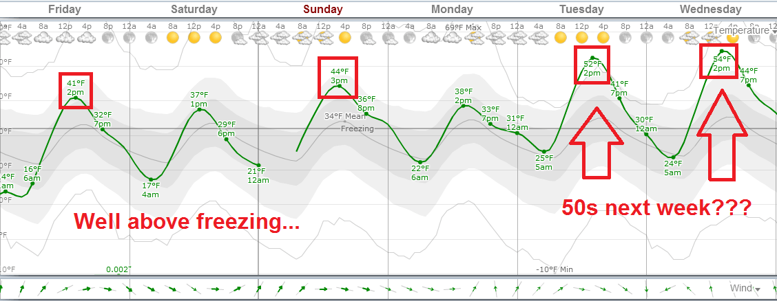
The GFS is cranking out similar numbers. Snow gone. Bare lawns and April showers in the second week of March? Nights above freezing?

Upper 50s -- even an isolated 60 degree -- now seems plausible for southern Minnesota late next week.
NOAA has latched onto the trend and updated the 8-14 day temperature outlook and splashed a bucket of red paint right over Minnesota.

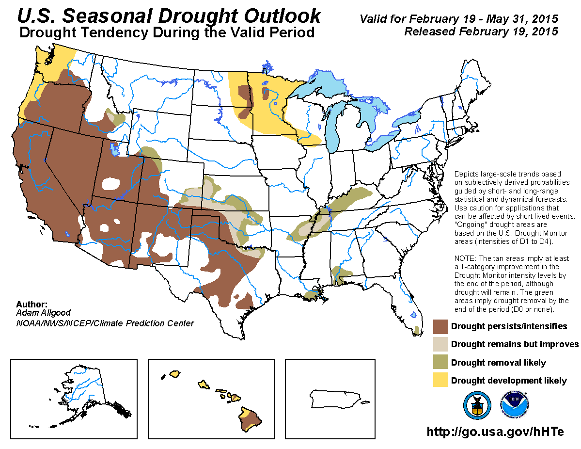
My weather spidey senses still tell me we will have to keep an eye out for developing drought this spring across the Upper Midwest. Heavy spring rains have saved us (flooded us) the past few years. One of these years, the spring rains may falter. My gut tells me this could be the year.
Here's NOAA's latest outlook for drought that seems to support my read of the developing spring pattern.
Enjoy what could be winter's last hurrah, and stay tuned!