Instant May: Pushing 70 degrees Thursday

Call it May-pril.
It seems we need to come up with new month names for our increasingly odd out-of-season weather patterns these days. Our March outlier weather winning streak continues this week.
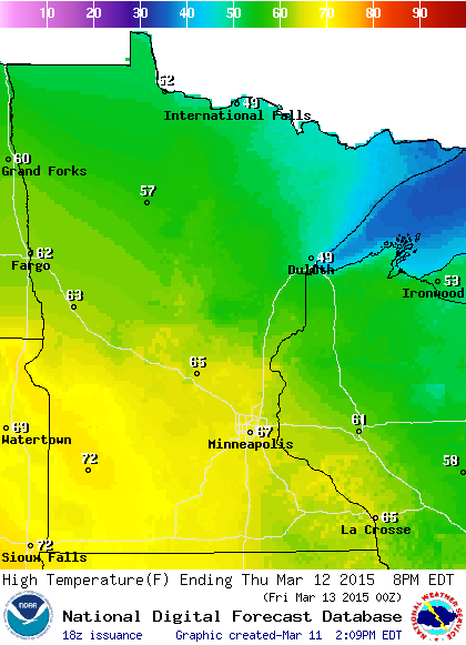
The recipe for temperatures 30 degrees above average in mid-March? One part increasingly warm March sunshine, an unseasonably warm and dry air mass, and bare brown soil to maximize low level solar heating. Thursday is one of those days. A south wind and all day sun means a race into the 60s. If everything goes just right temperatures may overachieve once again. I'm confident bank thermometers will flash 70 degrees in southwest Minnesota towns like Pipestone and Luverne Thursday afternoon. If all goes just right it should hit 70 in much of the Twin Cities by about 4 p.m. Thursday as Minnesota rides the northern edge of another near record mid-March air mass.
Create a More Connected Minnesota
MPR News is your trusted resource for the news you need. With your support, MPR News brings accessible, courageous journalism and authentic conversation to everyone - free of paywalls and barriers. Your gift makes a difference.
69 degrees - record high for Minneapolis-St. Paul International Airport Thursday
May 17th - date average high reaches 70 degrees at MSP Airport
Warm sector
That's what meteorologists call the area south of warm fronts attached to incoming low pressure systems. Minnesota basks in the warm sector again Thursday. Southerly breezes try and squeeze out every degree of potential warmth from the available air mass.

Friday's anemic cool front is another minor speed bump. Another warm front pushes temperatures higher again by Sunday, before a more significant correction next week. The National Oceanic and Atmospheric Administration's Global Forecast System model has been brutally underestimating this week's warmup by more than 10 degrees. I'm starting to think even the trusty European Centre for Medium-Range Weather Forecasts output below is having a hard time handling the magnitude of this outlier early season warm event.

The University of Maine's Climate Reanalyzer shows the next warm blob over the Midwest Sunday. Temperatures may once again flirt with 70 in southern Minnesota Sunday afternoon.

Active grass fire season
Our early warmth and dryness are combining to jump start what looks like an early and active grass fire season. Grass fire potential is already extreme in parts of South Dakota.

Springtime flash drought?
My concern about drought this spring has gone from growing to potentially alarming. I can't recall the last time I saw NOAA's GFS 16-day output for the Twin Cities crank out zero precipitation in the next 16 days. With 98 percent of Minnesota in pre-drought mode and a growing area of moderate drought, another dry two weeks is going to cause drought to expand rapidly across Minnesota.

Western drought amplifies
The ongoing western drought deepened this winter. Lack of snowfall in the west has produced some of the lowest snow pack levels on record.

That's water that the western states depend on for drinking and agriculture. Here's more from the U.S. Department of Agriculture.
Record Low Snowpack in Cascades, Sierra Nevada
WASHINGTON, March 11, 2015 – Warm temperatures in February contributed to further snowpack decline in the Cascades and Sierra Nevada, according to data from the third 2015 forecast by the United States Department of Agriculture's Natural Resources Conservation Service (NRCS). Snowpack in Nevada, Utah and Idaho also fell further behind normal.
"Nearly a third of our SNOTEL sites in the Cascades and Sierra Nevada are reporting the lowest snowpack ever measured," NRCS Hydrologist Cara McCarthy said. "For the first time, some sites were snow-free on March 1st. These areas can expect reduced summer streamflow."
Baked Alaska: Lack of snow moves Iditarod 250 miles north
The 7th warmest winter on record is having big impacts in Alaska. For just the second time in history the start of the Iditarod Trail Sled Dog Race is moving north from Anchorage. The race starts in Fairbanks this year.

Alaska is warming at a pace more than twice as fast as the rest of the US. Here's more from NOAA.
Alaska’s famous Iditarod Trail Sled Dog Race traditionally starts in the southern coastal city of Anchorage. Yesterday, however, the race kicked off in Fairbanks, 250 miles farther north, for the first time since 2003 and only the second time in the history of the race. Back in February, officials decided to reroute the trail due to a lack of snow cover and safety concerns.
The map at right show model-estimated snow depth across the state as of March 9, 2015. Snow depth increases from gray (one foot or less), to blue, to white (3 feet or more). Anchorage had only trace amounts of snow while Fairbanks was covered in 8-12 inches.
The historical Iditarod trail routes are shown in black. Upon leaving Anchorage, the trail splits into northern (used in even years) and southern (used in odd years) routes at the town of Ophir. This year, teams arriving from Fairbanks will intersect with the northern route at the town of Ruby. At Galena, the trail takes an additional detour, heading north to Huslia. As usual, the race will end in Nome. This year’s route is 18.65 miles shorter than the Anchorage-Nome route.
Except for three weeks in late January / early February, Alaska has been stuck in a pattern of mild temperatures since November. This is related to the warm-cold split that developed in the atmosphere over the Pacific and North America this past winter, which favored cold, snowy conditions in the east and left the western half of the country unseasonably warm and dry. If you happened to be in Fairbanks or Nome on February 24, for example, you would have been enjoying warmer temperatures (29°F and 28°F, respectively) than Chicago (16°F) or New York City (18°F).
Overall, Alaska experienced its 7th warmest winter on record this year, with an average temperature 11.1°F above the 1971-2000 average, marking the warmest winter for the state since 2002-03. According to the Third National Climate assessment, Alaska has warmed more than twice as rapidly as the rest of the United States over the past 60 years.