Sub zero readings possible Friday morning
Less than two weeks ago, on Nov. 2, the Twin Cities saw a high temperature of 56 degrees. But that sun-splashed Sunday seems so distant.
We have short memories. What has Mother Nature done for us lately?

Notice the relatively tight temperature profile between the maximum and minimum temperatures, a signal of cloud cover and a breeze in the overnight hours.
I don't see any change in this trend for the next five days.
Create a More Connected Minnesota
MPR News is your trusted resource for the news you need. With your support, MPR News brings accessible, courageous journalism and authentic conversation to everyone - free of paywalls and barriers. Your gift makes a difference.
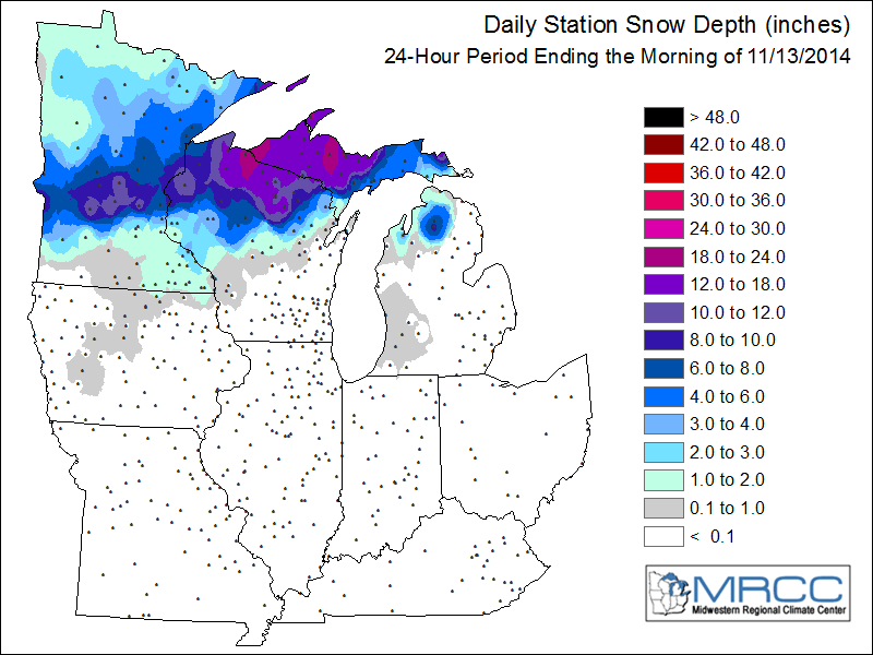
In one regard to the early winter cold and snow, take a look at the exceptional snowfall that has occurred this week in Michigan's Upper Peninsula. Ironwood reported 34 inches.
This lake effect snowfall occurs when colder air travels over the relatively warmer waters of the Great Lakes picking up moisture and depositing the snowfall across the landscape.
A longer fetch of winds across the open waters of the lake helps to enhance the snowfall accumulation. There is more time for the clouds to gather moisture to deposit the snowflakes inland.

This morning's snowfall map shows the extent of snow cover in Minnesota, Wisconsin and Upper Michigan.
As skies clear tonight and winds drop off, we set up the opportunity for sub-zero overnight low temperatures, particularly where the snow cover is significant.
I'm thinking the area from Little Falls to Milan has the best chance of seeing daybreak temperatures on Friday -- slightly below zero.

The record-low temperature for St. Cloud on Nov. 14 is 8 below zero, set in 1940. I think the record will stand.
I'm still tracking the chance for accumulating snow on Saturday for southern Minnesota. For this minor snowfall event, it appears the gradient for measurable snow will be quiet tight across central Minnesota including the Twin Cities.
A snowfall of one to three inches looks most likely from Marshall, through Owatonna to about Rochester.
The National Weather Service Office in Sioux Falls offers this graphical forecast heading into the weekend.
[image]
The National Oceanic and Atmospheric Administration's Weather Prediction Center is holding with the best chances for snow south of the Twin Cities.

If you are looking ahead to outdoor activities, on Saturday temperatures are expected to be mostly in the 20s statewide and winds are forecast to be rather light.

A re-enforcing shot of cold air arrives Monday and will keep afternoon high temperatures about 15 to 20 degrees below normal.
