First metro flakes? Clipper brings rain/snow mix Wed.

Here we go!
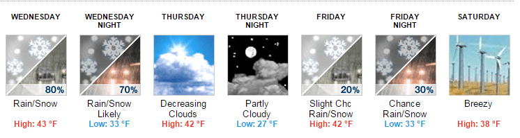
The season's first real Alberta clipper sails through Minnesota Wednesday.
No, we're not talking a February-style knock-down, drag-out, all-out, Red River Valley ground-blizzard-type clipper. But it does get your attention on the weather maps as a meteorologist.
The incoming low paints a swath of light precipitation across Minnesota Wednesday. Enough cold air has leaked south to produce a mix of rain and snow with this one.
Create a More Connected Minnesota
MPR News is your trusted resource for the news you need. With your support, MPR News brings accessible, courageous journalism and authentic conversation to everyone - free of paywalls and barriers. Your gift makes a difference.
The latest surface models take the system's track a little farther south which brings the rain/snow line close to the Twin Cities by Wednesday evening.

So far, Minneapolis-St. Paul International Airport has escaped even a trace of snowfall this fall. Temperatures in the lowest mile of the atmosphere look just cold enough that the season's first real snowflakes may fly in the metro Wednesday evening.
The best chance for accumulating snow Wednesday in Minnesota? From Bemidji through Brainerd, Duluth, Hinckley and maybe even as far south as the (northern?) metro.

Stretching out the forecast a bit, the Wednesday system is the first.
A weaker clipper may sideswipe Minnesota Friday. Temperatures will hover near the critical freezing point for possible rain/snow mixes. Yes, it's November and the 50s are history for a while, maybe longer.
Bottom line? Don't be shocked to see some snowflakes flying in the metro and points north by Wednesday evening.

Nice while it lasted!
Thanks to Bonnie Wilcox for this reminder of just how beautiful and enduring this fall has been in Minnesota. Bonnie, you must have a great microclimate for roses.
The longer-range maps still hint at persistent cold the next two weeks. Check out the Global Forecast System surface map for Saturday morning. That's an army of dashed blue lines rushing south under tightly packed isobars straight south from the Arctic Circle into Minnesota.

In weather geek speak we call this pattern "cold advection." Translation? A windy and increasingly cold air mass pumping into Minnesota Saturday.
Our November cold bias seems likely to stick around into mid-month at this point.


Lake Superior storm geeks unite
If you're into the gales of November, here's an event this weekend that may interest you from one of my favorite parts of Minnesota. It's called Lake Superior Storm Festival 2014. The event features a host of activities surrounding the lore of big weather on the North Shore.
There's nothing quite like a November gale — wind howling, icy waves lashing the rocks, a shiver of awe running down your spine. Treat yourself to a storm-season retreat before the bedlam of the holidays begins. This event honors the power and wild beauty of the Big Lake.
The event culminates with the annual tribute to the Edmund Fitzgerald on Nov. 10 at Split Rock Lighthouse.

I still have vivid memories of the howling winds as the gales of November took down the Fitz on Nov. 10, 1975. Thankfully, with advances in weather forecasting over the past 29 years, it is increasingly unlikely a similar event would occur today.