Friday night flakes: season’s first accumulations north
I had hoped to write this blog a few weeks later this year. Yes, even your local weather guy can come down with a bad case of seasonal denial.
All elements appear to be lining up for the first significant accumulating snows for parts of northern Minnesota Friday night. Even the Twin Cities metro area may see the first flakes of the season late Friday night into Saturday morning.
Maybe if I go to bed and pull the covers up really far it will all go away by Saturday morning?

Here's the system responsible for our wet and increasingly chilly forecast picture. The deepening surface low spins to near James Bay, then draws down an unseasonably cold November-like air mass into Minnesota this weekend.
Create a More Connected Minnesota
MPR News is your trusted resource for the news you need. With your support, MPR News brings accessible, courageous journalism and authentic conversation to everyone - free of paywalls and barriers. Your gift makes a difference.

Here are the latest probabilities of an inch or more by Saturday morning from the National Oceanic and Atmospheric Administration's Weather Prediction Center.

The Global Forecast System is aggressive with snowfall potential for north central Minnesota. A bull's-eye of 2 to 5 inches or more centered east of Bemidji? Flakes as far south as the metro?
[image]
Rainfall so far
The rain swath so far with this system has favored a Mankato-Twin Cities-Duluth line. Over an inch has fallen in a narrow band including Minneapolis-Saint Paul International Airport.

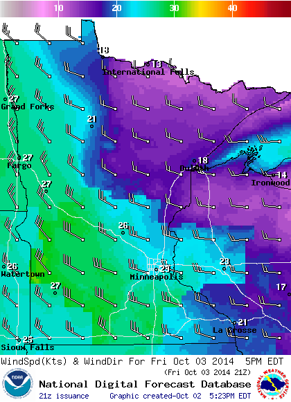
Wind next
Friday we awake to increasingly gusty northwest gales, and falling temperatures. Wind gusts over 40 miles per hour will leave no doubt this is October.
Was 82 degrees Sunday just a beautiful weather dream?
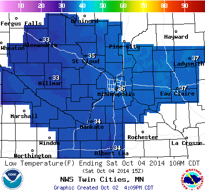
By Saturday morning, renegade October snowflakes give way to frost and near freezing temperatures for the metro. This could be the first frost of the season for the inner metro core. Cover up those petunias this weekend if you have any intentions of saving them.
November preview
The air mass over Minnesota will resemble November into early next week before a moderate warming trend.

Ghost of polar vortex?
There's just no way to sugar coat this one. The upper air pattern for next week looks eerily like the polar vortex patterns we saw last winter. Look at the Global Forecast System 500 millibar map for next Tuesday. A deep and unseasonably cold upper low swirling over southern Ontario. The ever persistent "Ridiculously Resilient Ridge" (Triple-R) over the West Coast.
Look familiar?

As expected, the accompanying medium-range temperature projections from NOAA's Climate Prediction Center for next week paint a big blue frosty bull's-eye right over Minnesota.

If this pattern sets up shop early and holds over Minnesota, it's going to be a long, long winter.
The big question? Will El Nino falter, or develop and ultimately save Minnesota and the Upper Midwest from another brutal Polar Vortex-driven winter?
Stay tuned.