Snow storm departs and chilly winds diminish today
Snow intensified over eastern Minnesota and northwest Wisconsin last night, dumping more than 11 inches of snow at Hutchinson, Minn., and Hawthorne, Wis.
Snowfall totals are posted as they are received by the National Weather Service. Check for the latest snowfall reports here.
The heaviest snowfall totals around the Twin Cities are coming in around 10 inches in Delano in the northwest suburbs in Wright County.
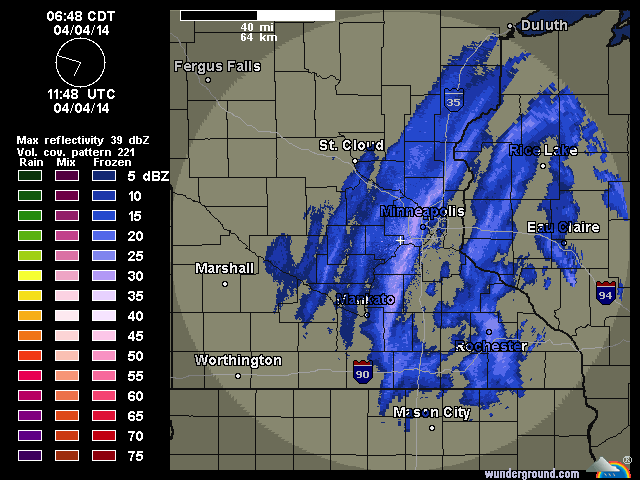
Weather radar shortly before 7 a.m. showed a band of heavier snow moving through the Twin Cities metro area. The snow will diminish and end in east central Minnesota at mid morning. Brisk north winds will keep a nip in the air.
Create a More Connected Minnesota
MPR News is your trusted resource for the news you need. With your support, MPR News brings accessible, courageous journalism and authentic conversation to everyone - free of paywalls and barriers. Your gift makes a difference.
Sunshine returns as we move through the afternoon hours and some melting is likely to commence.
Severe thunderstorms and a small risk of tornadoes are in the forecast for the locations in the warmer air, well southeast of Minnesota.
[image]

Expect chilly conditions to begin the day on Saturday. Overnight lows will dip into the teens and perhaps the single digits over the fresh snow cover in northeast Minnesota and northwest Wisconsin.
Relatively quiet weather is in store for Saturday and Sunday, although a mixture of light rain and snow is possible in central Minnesota on Sunday.
The moisture from Thursday night and Friday's snow storm is welcome in portions of the Minnesota River Valley, where drought conditions remained into early April. Up to an inch of moisture likely fell in the most parched regions.

Doppler radar painted this graphic of estimated water content of precipitation through 7:23 a.m.

Baseball returns to Target Field for the 2014 season opener on Monday. When I visited the weather lab on Tuesday, the ball park playing field looked in mid season shape.

High temperatures on Monday are expected to be close to the seasonal normal, in the lower 50s.
