Major late season winter storm looks likely Thursday and Friday
I keep looking for an escape hatch with our incoming winter storm. So far I can't find one.
All systems appear to be "go" for a late season major winter storm Thursday and Friday for eastern South Dakota, Minnesota and northwest Wisconsin. The only questions now may not be if, but when and how much?
Here are the latest headlines for our incoming major late season winter storm.
Create a More Connected Minnesota
MPR News is your trusted resource for the news you need. With your support, MPR News brings accessible, courageous journalism and authentic conversation to everyone - free of paywalls and barriers. Your gift makes a difference.
Winter storm watches likely upgraded to warnings this afternoon.
Latest storm tracks favor heavy snow totals over or close to the Twin Cities metro
Wintry (icy?) mix possible Thursday morning rush, mixed precipitation Thursday
Heavy snowfall looks more likely Thursday night into Friday morning
Snowfall rates could reach 1 to 2 inches per hour Thursday night/Friday morning (thunder snow is possible)
Snow melts this weekend with temperatures in the 40s; temps in the 60s to near 70 degrees may return late next week!
Denial: early April in Minnesota
I keep thinking the weather maps these days are like a bad Minnesota dream.
Spring in Minnesota is like Peanuts. Just when Charlie Brown thinks spring is finally here, Lucy pulls the football away (again) at the last second. That scream you hear is the collective whine of most Minnesotans who are so done with winter by now.
It's looking more likely that somebody in Minnesota is going to get whacked with more than a foot of snow by Friday afternoon. It's just a question of where. The Twin Cities seem like a pretty good candidate as the various model runs roll of the presses.
Here's the latest thinking from the Twin Cities National Weather Service on that pressing question.
[image]
Storm track
The latest model runs are in fairly good agreement about the likely track of the surface low. A Kansas City, Mo., to Madison, Wis., storm track? That's usually very favorable for heavy snow across southern Minnesota including the Twin Cities.
Here's the storm track loop -- a classic Panhandle Hooker from the National Oceanic and Atmospheric Administration's National Digital Forecast Database.

Today is the calm before the storm. Sunshine and quiet weather gives way to the first wave of wintry precipitation overnight tonight.

An icy mix by Thursday morning could mean slick roads early Thursday morning before temps have a chance to warm above freezing. Here's the take on that and the storm to follow from the La Crosse, Wis., NWS.
[image]
Snowmageddon 2014?
I'm not totally convinced just yet, but this system appears to have all the right dynamics to produce heavy, even prolific snowfall totals. I still want to see today's and tonight's model runs, but the forecast models are cranking out some impressive, even staggering snowfall totals at this point.
A swath of 6 to 12 inches seems very reasonable at this point, and some models hint at as much as 16 inches somewhere in MPR Land.
Here's NOAA's Global Forecast System take on potential snowfall distribution.

NOAA's NAM model is cranking out snowfall rates of 1" to 2" per hour early Friday morning and some incredible (unbelievable?) snowfall totals of 17 inches for the metro. This may be overdone...but it certainly gets your attention.
[image]
Historic April snow event?
If the models pan out, we could be looking at a top 10 historic April snow in the Twin Cities. Here's more from the Minnesota Climatology Working Group.
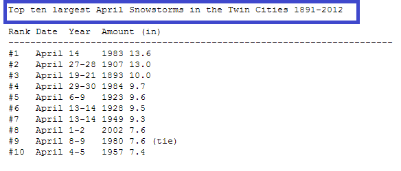
The largest April snowstorm in the Twin Cities happened on April 14, 1983. A strong area of low pressure had ample moisture to work with and deepened over northern Iowa as it moved to the east and northeast. The event started as rain on the 13th and changed over to snow during the wee hours of April 14th.
Persons in east central Minnesota were surprised to wake up to a foot of snow on the ground with brilliant morning sunshine. The grand total at the Twin Cities airport from that storm was 13.6 inches. The Metrodome deflated for the third time since its construction in this storm. (The first two times were Nov 21, 1981 and December 30, 1982.)
Over 400 schools canceled class on April 14 and the University of Minnesota shut down at 2:30pm. Residential mail deliveries and pickups were canceled for only the third time in 20 years. The Twin Cities International Airport was shut down for 5 hours from 9am to 2pm on the 14th.
National impacts
Winter storm watches cover a big footprint in the Upper Midwest. Red flag warnings are flying for high winds and warm dry air on the southern (drier) side of the incoming storm.

Severe outbreak in between
It doesn't take a rocket surgeon to see this system has all the makings of a severe weather producer in the Central Plains. Here's the risk area from NOAA's Storm Prediction Center, which does a good job of highlighting the threat areas.

Look for severe thunderstorms with damaging winds to 70 mph+ and a few tornadoes in the next 48 hours. The biggest threat areas? Oklahoma City, Okla., and Tulsa, Okla, through Little Rock, Ark., Springfield, Mo., to St. Louis, Mo., and Memphis, Tenn.
Good News: Snow melts this weekend and 60s may return next week
I can't leave all of you loyal Updraft readers hanging without some positive trends for spring ahead.
The maps look very encouraging for another big warm up late next week. Temps could easily soar into the 60s again and the season's first 70 degree temp is not out of the question in the metro next Thursday.

Hang in there Charlie Brown!