Windy Wednesday, Thursday slop-storm, warmer weekend

Try and keep up.
That's the message to weather folk from the maps these days. Don't like the weather? Just wait 15 minutes. The best read today on the forecast for the next week? In a word: change.
Here's a breakdown of what looks like a rapidly changing weather scenario the next few days in Minnesota.
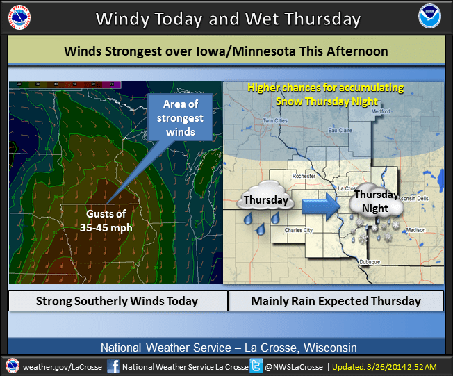
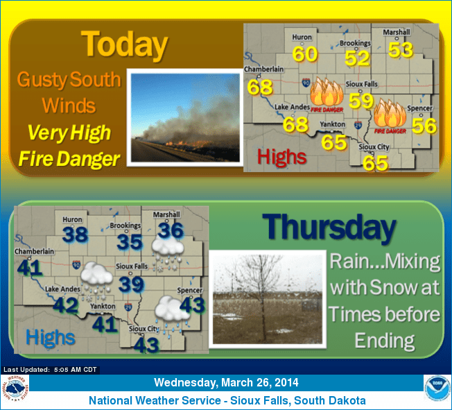
The winds of March ramp up today. Look for breezy to windy conditions, with gusts to over 40 miles per hour possible in southwest Minnesota. Wind advisories are flying for southwest Minnesota today.
Create a More Connected Minnesota
MPR News is your trusted resource for the news you need. With your support, MPR News brings accessible, courageous journalism and authentic conversation to everyone - free of paywalls and barriers. Your gift makes a difference.

The winds will feel milder by late afternoon, as temps rise to near 40 in the metro and soar into the 50s and 60s in southwest Minnesota and eastern South Dakota. That's the perfect recipe for high fire danger in the now snow free zones to the southwest.
Here's a great animation of the low pressure system out west as it rides in Thursday. Click the map to get it rolling.

Thursday slop-storm
I'm still waiting for the "easy" winter or spring storm system to roll into Minnesota. This one is no different, with the rain/snow line hovering over the Twin Cities and southern Minnesota Thursday afternoon.
The latest trends? The National Oceanic and Atmospheric Administration's North American Mesoscale Forecast System and Global Forecast System are selling a solution that would bring the expected morning rain but then an earlier change over to snow in the metro around or after noon.
That could mean several hours of mixed snow trending to wet snow and slushy accumulations.
I'm still a bit skeptical we'll stay all snow all afternoon, but that's what the latest model trends show.
With temps in the upper 30s and daytime, it may be hard to accumulate snow, but the latest model trends say anywhere from a slushy coating to a few inches of slush are possible by Wednesday evening.

Stay tuned. We may still have more work to do on potentially changing forecast details for the metro Thursday afternoon and evening.
The best chance for another plowable snow event includes Duluth and the North Shore. Icing may be an issue near and south of Duluth.

There is hope! Weekend warm up still on track
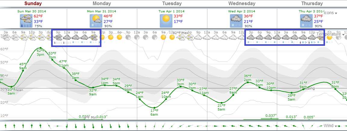
As wintry as Thursday afternoon and evening may feel in parts of Minnesota, the weekend looks more like spring. Some sunshine and 40s Saturday and 50s Sunday will be good tonic for the winter weary Minnesota soul.

We should melt some serious snow this weekend. Sunday looks like the warmest day in a while across most of Minnesota.

Enjoy the weekend warm up. The maps hint at a cooler and wetter trend next week with rain/snow chances Monday and again Wednesday.
I'm not convinced yet we'll be as cool as the European Centre for Medium-Range Weather Forecasts trends below suggest, but the metro may ride the rain/snow line once again on systems next week.
One thing to keep in mind, models are very changeable this time of year as north-south temperature differences are sharp.
Case in point? Opening day outlook for the Twin April 7. In the past three days I've seen models spit out everything from a sunny 71 degrees to 39 degrees and a cold drizzle for Opening Day.
Spring will make headway the next few days and weeks, but it's often a two steps forward, one step back event. In theory, the valleys and highs are getting higher overall, and eventually spring sneaks in on cat's paws.
Stay tuned and hang in there! Do we really have any other choice?