Southern Minnesota Clipper morphs into major winter storm for Chicago and Northeast
March Cool Fronts
Our "cool fronts" now are warmer than our warm fronts a week ago.
Progress.
Today's cool front drops temperatures to the 30s and into the 20s later tonight. The "frontal band" brings a rainy mix that trends to all wet snow in southern Minnesota today. The Twin cities metro area escapes this one, but southern Minnesota along the Interstate-90 corridor picks up a good one to two inches or more of heavy wet March snow today.
Create a More Connected Minnesota
MPR News is your trusted resource for the news you need. With your support, MPR News brings accessible, courageous journalism and authentic conversation to everyone - free of paywalls and barriers. Your gift makes a difference.
[image]
Not so lucky in Chicago
Winter took a big hit in Minnesota the past few days, but rears it's persistently ugly head again today in Chicago and points east.
Our southern Minnesota Clipper picks up steam, and morphs into another productive snow event from Chicago through Detroit, Cleveland, Buffalo and Upstate New York and northern New England.
Here's the weather story from our friends in the Chicago area National Weather Service.
[image]
Here's this morning's multimedia weather briefing from the Chicago NWS.
The storm lays out a growing and impressive band of warnings from Chicago to Maine.

Here's a great look at the evolution of the deepening system as it winds up and rolls east from National Oceanic and Atmospheric Administration's North American Meso model. Click on the map below to animate the next 84 hours.

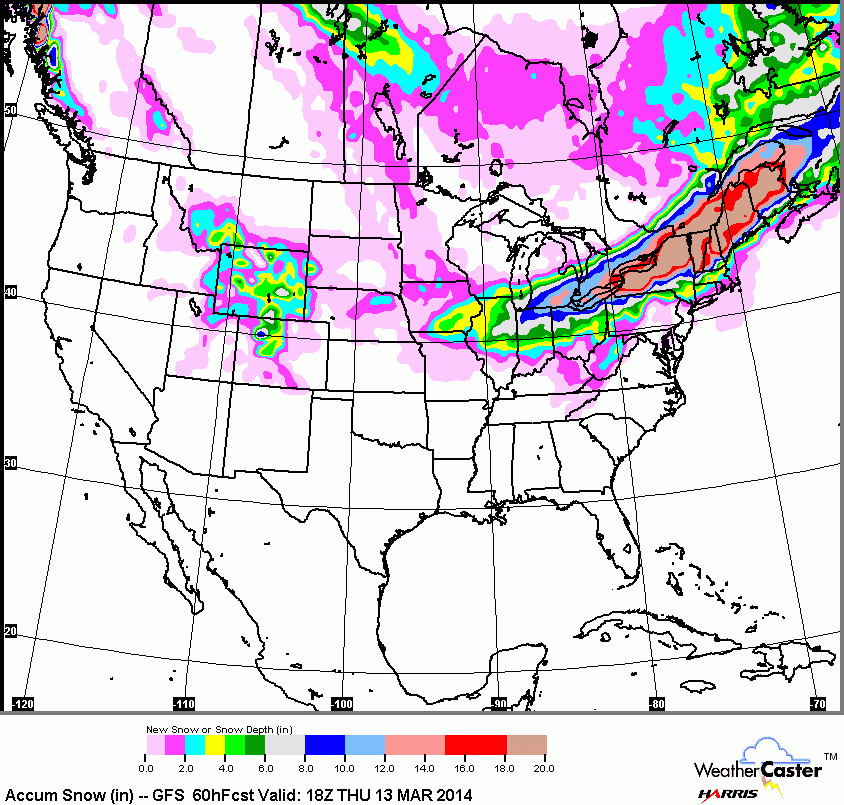
Here's the latest snow projection, a narrow band of 6 to 12 inches from Chicago to Maine.

Bottom Line: Keep an eye on this storm if you are planning travel out east through Thursday morning.
Roller Coaster week ahead
The temperature trend is downward for the next 36 hours. Then another welcome warm front arrives, and temps soar back into the lower 40s as southwest winds blow over snow free areas into Minnesota Thursday afternoon.

Speaking of snow cover, it took a big hit after Monday's mega-thaw. The back edge of snow cover now cuts into western Minnesota.

March 2014: More spring than winter?
March is a month that is usually more winter than spring in Minnesota. This year, it looks like it may trend more spring than winter. A major March snowstorm could pop up on the weather maps at a moments notice, but right now the longer range products steer any big snows away from Minnesota the next two weeks.

Temperatures roller coaster up and down as a series of warm and cool fronts sweeps across the state in the next two weeks. The 16-day Global Forecast System model suggests we probably spend more days in the 40s to near 50 degrees than in the 20s and low 30s. With the higher March sun angle, we'll probably melt much more snow than we make this month.
Stay tuned!