Raleigh Gridlock: ‘Snowpocalypse II’ in progress
Here we go again.

Another southern storm. Another gridlocked southern city. This time Raleigh, N.C., is at the epicenter for Snowpocalypse II.

Heavy snow at the rate of 2 inches per hour slammed Raleigh today and traffic quickly ground to a standstill in many parts of the city. Reports of 4 to 5 hour gridlock are common in Raleigh-Durham and Charlotte, N.C., today as the snow blitz ramps up. There's a lot of red on the traffic maps in North Carolina.

In all the extreme winter weather we have in Minnesota, I can't remember ever seeing the National Weather Service issue a warning to "stay home." But that's exactly what NWS Raleigh is advising with this storm.
Create a More Connected Minnesota
MPR News is your trusted resource for the news you need. With your support, MPR News brings accessible, courageous journalism and authentic conversation to everyone - free of paywalls and barriers. Your gift makes a difference.
URGENT - WINTER WEATHER MESSAGE
NATIONAL WEATHER SERVICE RALEIGH NC
511 PM EST WED FEB 12 2014
...SIGNIFICANT WINTER STORM ACROSS CENTRAL NORTH CAROLINA...
VERY DANGEROUS WINTRY WEATHER WILL CONTINUE ACROSS CENTRAL NORTH CAROLINA THROUGH THURSDAY. TRAVEL WILL BE EXTREMELY DANGEROUS...AND RESIDENTS ARE STRONGLY ENCOURAGED TO STAY HOME.
...WINTER STORM WARNING REMAINS IN EFFECT UNTIL 6 PM EST THURSDAY...
* LOCATIONS...THE TRIAD AND NORTHWEST PIEDMONT.
* TIMING...ACCUMULATING SNOW WILL CONTINUE IN THE TRIAD AND THE NORTHWEST PIEDMONT...THEN MIX WITH SLEET LATE THIS EVENING AND OVERNIGHT. ANOTHER ROUND OF ACCUMULATING SNOW IS LIKELY ON
THURSDAY.
* ACCUMULATIONS...SNOW AND SLEET ACCUMULATION OF 6 TO 9 INCHES THROUGH TONIGHT. ANOTHER 1 TO 4 INCHES WILL BE POSSIBLE ON THURSDAY.
* IMPACTS...SIGNIFICANT SNOW AND ICE ACCUMULATION WILL SEVERELY DISRUPT TRAVEL ACROSS THE AREA BY LATE THIS AFTERNOON...AND MAY LAST FOR A COUPLE OF DAYS. POWER OUTAGES WILL BE POSSIBLE.
Storm rolls north
Next up D.C., Philly, New York, Jersey and Boston. Here's the latest surface map loop showing the low winding up and heading north. Click on the image below to animate the maps.

Next Up: Washington, D.C.
Snow is moving into Washington, D.C., as I write this. The snow slams the city overnight into Thursday. Heaviest totals will be inland as warm air wraps into the system from the Atlantic.
Here's the latest storm scenario from the D.C. area National Weather Service.
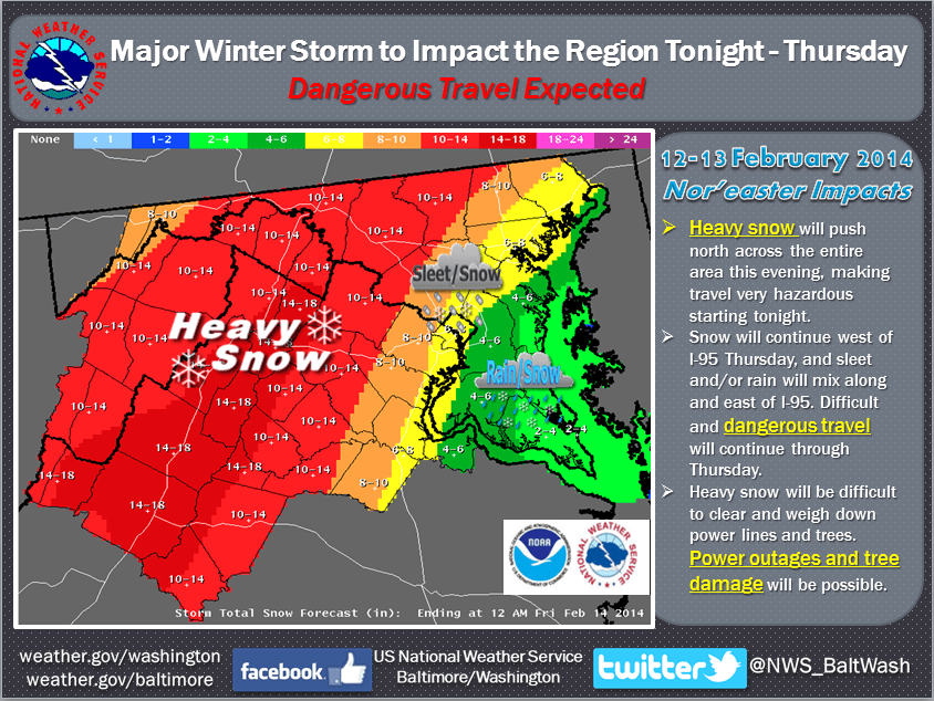
The storm sweeps northeast Thursday. Philly and New York will get snow, but inland areas will be hardest hit.

Up to a foot of snow will fall inland with this storm. Metro New York City and Long Island, N.Y., will get their share of snow and wind..

Bottom Line: The Interstate 95 winter storm rolls on Thursday. Expect more travel problems at airports and on the roads all along the East Coast.
The perspective and big picture?
Again, it amazes me how people got caught off guard in North Carolina today ahead of a well forecast storm. It's another reminder of how well the process works in Minnesota with good weather forecasts and warnings, then action by the Minnesota Department of Transportation and city/county road crews.
We keep going, without major gridlock in this magnitude of storms most of the time in Minnesota.
I heard the governor of North Carolina say they have spent $30 million recently on winter storms. How much of that could have been saved by more efficient processing of weather forecast information, good communications and timely operations by road crews in North Carolina? Why didn't North Carolina follow Georgia's lesson from two weeks ago and declare a state of emergency before the storm hit?
It never ceases to amaze me how states and cities will spend millions on storm aftermath when a few hundred thousand spent up front on accurate weather forecasts and communications could save millions, and improve safety for the public.
An "ounce of prevention" as they say. There. I'm stepping off my weatherman soap box now.

Minnesota: Operation warm-up begins
Temps are heading in the right direction for many Minnesotans these days. We top out close to 30 degrees Thursday in the metro, before an atmospheric speed bump cools temps slightly Friday and into the weekend. Light snowy dustings are possible early Thursday and again Saturday.

Next week looks decidedly warmer as upper winds blow in from the Pacific. A string of days in the 30s looks likely, and we may top out at or above 40 degrees next Wednesday.

The longer rage forecast still looks much milder than what we've endured the past two months.
Have we broken the back of winter's sub-zero cold in Minnesota? We usually sneak in one or two more sub-zero mornings, but I think the worst of the cold is behind us now. Look for far more days in the 30s the next two weeks than sub-zero mornings.
Many of you have told me you are loving the notion of a thaw. Some of you have asked about weather for the American Birkebeiner in Wisconsin on Feb. 22. The early read is for temps in the teens or low 20s. That's forecast may change of course, but if it holds that would be good news.
It would be a shame to have such great snow all winter then have a thaw for the Birkie!

Good luck to all the racers and spectators!