Chilly week, Snowmageddon on tap for Northeast?
Keeping out the riff raff
That's what my dad used to say about our Minnesota winters. I'm pretty sure he meant that our cold climate prevents us from being overrun by the masses seeking the higher quality of life that Minnesota has to offer.
Can you imagine the Twin Cities with a population of more than 10 million? A Nordic Chicago or Dallas? No offense intended, but I like Minnesota just fine the way it is thank you.
This week's arctic relapse provides another benefit for many -- an absence of brutally snowy commutes. The descending arctic air mass pushes in Tuesday night, and locks down with more sub-zero temps and wind chills Wednesday into Friday.
Create a More Connected Minnesota
MPR News is your trusted resource for the news you need. With your support, MPR News brings accessible, courageous journalism and authentic conversation to everyone - free of paywalls and barriers. Your gift makes a difference.
It's not as brutal as what we endured in early January, but it will get your attention. The arctic dome over Minnesota will steer storm systems to the south this week. The next one brings snow as close as the far southeast tip of Minnesota Tuesday.

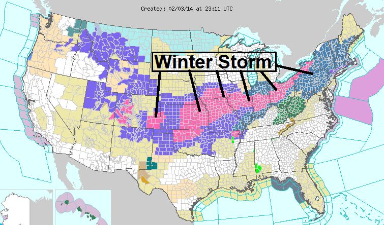
Major winter storm plows south
The next winter storm plows through Tuesday with a narrow band of 6 to 12 inches or more from Kansas to south of Chicago all the way to the east coast. A stripe of winter storm warnings and advisories covers at least 27 states, from Colorado to Maine.
Here's a look at the North American Mesoscale model derived snowfall totals with the system.

Kansas City bull's-eye?
The heaviest snow axis may center on Kansas City and Lawrence with his system, then shoot east toward Decatur, Ill., and Bloomington, Ill. The Kansas City office of the National Weather Service has a nice summary of the incoming storm.
[image]
Snow blitz out east this week.
Round one dumped 8 inches New York's Central Park Monday.
Round two cranks up Tuesday night and Wednesday.
727 PM EST MON FEB 3 2014
...WINTER STORM WATCH REMAINS IN EFFECT FROM LATE TUESDAY NIGHT THROUGH WEDNESDAY AFTERNOON...
* LOCATIONS...NEW YORK CITY...NASSAU COUNTY...NORTHEAST NEW JERSEY AND THE LOWER HUDSON VALLEY.
* HAZARD TYPES...SNOW...SLEET AND FREEZING RAIN.
* ACCUMULATIONS...SNOW ACCUMULATION OF 4 TO 8 INCHES FOR METRO NEW YORK CITY AND NORTHEAST NEW JERSEY...6 TO 10 INCHES FOR THE LOWER HUDSON VALLEY AND ...ALONG WITH UP TO 1/2 INCH OF ICE.
* VISIBILITIES...ONE QUARTER TO ONE HALF MILE.
* TIMING...SNOW LATE TUESDAY NIGHT THROUGH WEDNESDAY MORNING... MIXING WITH AND CHANGING TO SLEET AND FREEZING RAIN NEW YORK CITY METRO AND NORTHEAST NEW JERSEY.
* IMPACTS...SNOW AND ICE ON ROADS WILL CREATE HAZARDOUS TRAVEL.
Bigger Snowmageddon next weekend?
The first two storms may be the appetizers. A big, powerful nor'easter will grab headlines, and may dump copious snowfall totals in the northeast U.S. by Sunday and Monday.

It may be warm enough on the coast for mostly rain with this system, but we could be taking 2 to 3 feet of snow inland. It's early but stay tuned on this one.