Tracking the polar vortex: Winter’s coldest days behind us after this week?
Milder 2nd half of winter?
Believe it or not, we reach the halfway point of winter next week.
Jan. 15 is the mid-point of meteorological winter. (December-February) Looking at longer range weather patterns and so called "teleconnections" that forecasters use to make seasonal weather forecasts, I can only reach one conclusion.
The worst of winter's cold is likely behind us after this week. There, I said it.
Create a More Connected Minnesota
MPR News is your trusted resource for the news you need. With your support, MPR News brings accessible, courageous journalism and authentic conversation to everyone - free of paywalls and barriers. Your gift makes a difference.
There are several lines of evidence that point to a milder second half of winter for Minnesota and the Upper Midwest.
Don't bet the farm just yet, but here's why I really think the coldest part of winter is behind us after this week. And crawling way out on a weather limb, I also think there is a very good chance we'll see a much earlier spring than last year.

Long December
A long December and there's reason to believe
Maybe this year will be better than the last -- Counting Crows
A Long December is a great Counting Crows song, and a tough weather reality for Minnesotans.
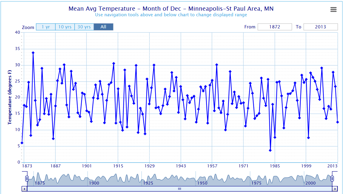
Dec. 5 is the day winter really began in Minnesota. Temps in the metro plummeted toward the first zero degree reading of winter in the metro.
December's persistent "northwest flow" in the upper levels dealt us persistent cold waves. Overall temperatures for the month ran -7.5 degrees vs. average, good enough for the 18th coldest December on record.
New Year's Chill
2014 picked up right where December left off. The first week of 2014 is running an amazing -17.5 degrees vs. average so far.

Conclusion: The 1st half of meteorological winter will go down close to -10 degrees vs. average. That level of departure from average is difficult to sustain in any season.
Sub-Zero days piling up
12 days at or below zero all of last winter
13 days at or below zero in December
20 days at or below zero so far this winter (Through Jan. 7)
Prediction: It is my view that we are highly unlikely to sustain this rate of sub-zero days for the rest of the winter season.
Tracking the polar vortex: changes ahead
I've been using the term polar vortex since my days in the WGN-TV Weather Center in Chicago in the mid-1990's. WGN's extraordinary meteorologist Tom Skilling and I used to analyse the European Centre for Medium-Range Weather Forecasts model by hand as it came into the weather center on over-sized facsimile printers that hissed away as the model runs poured in.
Our latest invasion of the polar vortex captured global attention. The persistent swirling upper level low pressure system spun over Hudson Bay in December, dealing Minnesota our series of cold air masses. It finally broke look this week, and delivered the coldest temps in 10 years to the Twin Cities.
The fact that the polar vortex finally broke loose may lead to potentially major changes for the rest of this winter. My experience is once persistent large scale hemispheric upper air patterns shift, they tend to reorganize in different areas. That usually leads to the opposite type of weather for many regions.
Take a look at the series of images below. These upper air maps from the National Oceanic and Atmospheric Administration's Global Forecast System model show the likely progression of the polar vortex over the next two weeks. Notice the dramatic shift to the north over the next two weeks.
Here's the map from Monday showing the polar vortex sweeping down over the Great Lakes into the United States.

By next week the polar vortex retreats well north into Canada. That opens the door for a much milder Pacific air flow into the Midwest and broader U.S.

A week later, and the GFS predicts the polar vortex may retreat all the way north to the Arctic Circle. This west to east 'zonal' flow pattern could mean an even milder air mass streaming into the U.S., and southern Canada from the Pacific.

Keep in mind this is one model run, but the trend has been evolving over several days now which usually builds confidence. It still appears there will be brief arctic incursions in the next 2 weeks, but they will be shorter and not as severe as the brutal outbreak we endured this week.
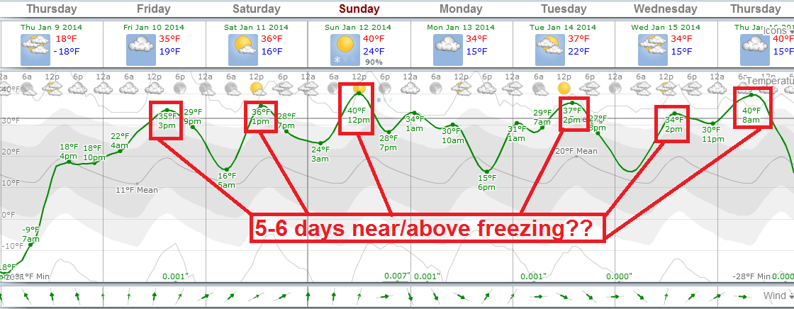
In the short term, Minnesota appears to be on the verge of a week long warming trend starting Thursday and Friday. The European model is most aggressive with the warm up, and suggests a significant January thaw with several days above freezing, and a week long hiatus from sub-zero temps.
In the longer range, the GFS is cranking out many more days in the 20s and 30s, and far fewer sub-zero nights.

Developing El Nino in 2014?
It's still early, but most of the forecast models streaming into NOAA's Climate Prediction Center suggest the tropical Pacific will warm in 2014. That could lead to a developing El Nino later this year.

Potential impact: As the Pacific warms. it may trigger changes in the jet stream over North America as early as the second half of winter and spring of this year.
Bottom Line
Temps look to run as much as 5 to 10 degrees warmer than average overall for about two weeks in Minnesota starting on Friday of this week.
By then we are approaching February, and my read on the second half of winter is for a more frequent zonal flow pattern. That should bring more frequent Pacific air masses with winds blowing from Seattle instead of the Yukon.
At this point I expect an overall trend that will favor a much milder second half of winter than what we've endured since Dec. 1.
Stay tuned, and hang in there!