‘Coldest’ winter in 32 years? Alaska’s record 62 degree warmth, Icy Dixie disaster

Coldest winter in 32 years?
It's not apples to apples, but by one measure this is the coldest winter in the metro in 32 years through December and January. The last time we saw this many days of sub-zero cold was in 1981-82.
Here are the teeth chattering numbers from the Minnesota Climatology Working Group.
Create a More Connected Minnesota
MPR News is your trusted resource for the news you need. With your support, MPR News brings accessible, courageous journalism and authentic conversation to everyone - free of paywalls and barriers. Your gift makes a difference.
Minnesota Climatology Working Group
Minimum Temperatures of zero or colder in the Twin Cities Through Jan 31
The Twin Cities will most likely have the mercury dip to zero or colder 32 times this winter by January 31, the most through January 31 since the winter of 1981-82.
How does the winter of 2013-14 stack up for counts of minimum temperatures at or below zero in the Twin Cities? As of January 28th there have been 30 minimum temperatures of zero or colder: 13 in December, and 17 so far in January. Including the forecast for the rest of the month it looks like January will wind up with 19 minimum temperatures of zero or colder for a total of 32 so far for the season.
This is the most number of minimums below zero so early in a winter since the winter of 81-82 when the total through January 31 was 33. The most in a winter through January 31 is 44 from the winter of 1976-77. If the forecast holds, 2014 will be in a four way tie for the 13th most lows of zero or colder going back to the winter of 1872-1873. Excluding the 19th century winters, this winter would tie for 7th place, an impressive feat given the heat island of the modern Twin Cities Metro Area.
The somewhat sick news? If we make the expected 32 days of sub zero by this weekend, that's only good enough to tie for 13th place!
Minnesota Climatology Working Group
Weather in backwards
The weather maps are upside down this January. Alaskans enjoyed another balmy January day with record temps and no snow cover in many places.
The North Platte, Neb., National Weather Service office "Weather Story" shows what we call a high amplitude blocking jet stream pattern shoving mild air into Alaska, and bitter cold into the Deep South.
North Platte NWS
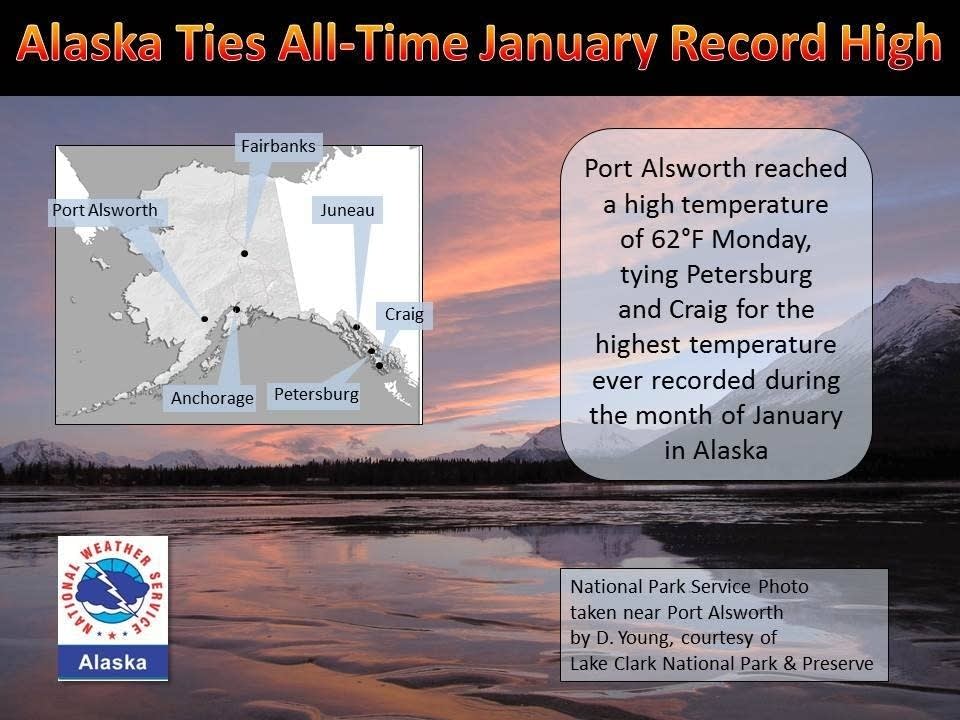
Baked Alaska: 62 degrees sets all time record for January in Alaska
Did I read that right? It's 62 degrees in Alaska in January while we shiver in sub zero chill? Maybe I need to rethink the whole Arizona snowbird thing and look north.
Here are the details on tying the warmest temp ever recorded in Alaska in January from the Alaska NWS Facebook page.
The extreme warmth that has covered much of Alaska for the past ten days reached a peak Monday as the Climate Reference Network station near Port Alsworth, in Lake Clark National Park and Preserve, reported a high temperature of 62°F. This equals the highest temperature ever recorded in Alaska during January.
Temperatures this mild in January have previously only been observed in Southeast Alaska. A high of 62°F was observed at Petersburg on January 16, 1981 and at Craig on January 30, 1940.
Late Tuesday afternoon it was 43 degrees in Anchorage, Alaska. It was 21 in Atlanta. Twenty-two degrees warmer in late January in Alaska than Atlanta? That's a recipe for weather trouble.
Dixie disaster
At the bottom of the polar vortex, Dixie is digging out from several inches of rare snowfall, and skidding on glaze ice. Metro Atlanta roadways looked like parking lots Tuesday.

Afternoon rush was anything but in Atlanta Tuesday. Roads were gridlocked. Reports say children were stuck on school buses for hours, then returned back to school because they can't get the buses home. The Atlanta traffic map shows plenty of red on the system late Tuesday.

'Civil emergency'
Two words you never want see in the forecast. A civil emergency is in effect for over half of the state of Alabama from the snow and ice storm.

Keep in mind, many southern states and cities do not have snow and ice removal equipment or even road salt. A coating of ice and a few inches of snow is a tough commute in Minnesota. In Alabama, it's a crippling event.
Civil emergencies have been declared in parts of several southern states including Mississippi, Alabama and South Carolina. Winter storm warnings blanket the Deep South all the way to the Gulf Coast.

Snow flurries in Dixie are rare enough. Two to 4 inches is a once in a generation event. That's why many southern drivers have never even driven in snow before. Combine that with the near absence of plows and salt truck, and you have the makings of a weather nightmare. Here's a look at the swath of 2 to 4 inches that will blanket much of Dixie into Wednesday.

Bottom line: This week's ice and snow event in the Deep South is causing nothing short of havoc. Expect flight delays in Atlanta and other southern destinations, and travel by road will be nearly impossible in some areas through Wednesday.
Minnesota Chill Eases
Another day, another -16 degree low at Minneapolis-St. Paul International Airport. And that only ties for the 4th coldest temp this winter?
Temps plunged into the -20s in many outer metro suburbs, while the infamous urban heat island held temps in the teens below in most of the inner metro core inside the 494/694 freeway loop. Maybe the urban "not so Nordic" island is a better description this winter.
Want some milder weather news? The cold eases Wednesday, and temps in the 20s above zero may actually approach average for late January. We cool off again the rest of the week into the weekend, but temps will not be as brutal as what we've seen early this week. Lighter winds should rule under high presure next weekend. That should give the blizzard warnings a rest for a while.
The National Oceanic and Atmospheric Administration's Global Forecast System model has done the best job with Minnesota's wild temp swings this winter. Here's the latest GFS output from Weatherspark.

Super Bowl: Cool but dry
Looks like the early Farmers' Almanac predictions of a Super Bowl blizzard were just hype. Where did I put my shocked face?
The latest actual meteorology suggests a departing system over the Atlantic, and a chilly but dry northwest breeze at kickoff Sunday.

Some light rain and snow mixed may roll through Saturday night into Sunday morning, but with drier skies temps in the upper 30s at game-time, it could be much worse. Weather does not a look alike a big factor in Sunday's outdoor Super Bowl.

The forecast for your family room or Super Bowl party? Scattered appetizers, inventive $3 million TV ads and temps near 70 degrees.