Minnesota goes back into the deep freeze
A snowfall of 3 to 7 inches occurred around Bemidji, Minn., to the Twin Cities and southeast to Wabasha, Minn., on Friday night and early Saturday.
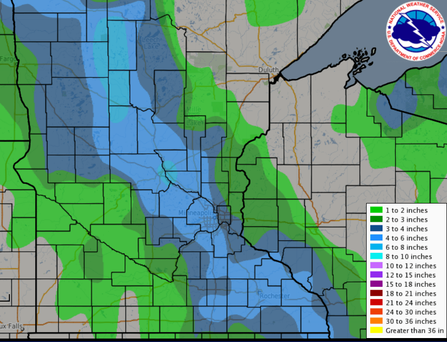
By mid-morning on Saturday, the snow ended and skies cleared. Light weekend traffic allowed the road crews to efficiently plow the highways. Afternoon sunshine melted most of the residue in the greater metro region.
Sunday brought a nice run-up on the thermometer, particularly in southern Minnesota. Madison, in west central Minnesota, topped out at 45 degrees and the Minneapolis-St. Paul International Airport recorded a high of 39.
Another shot of arctic air was moving through the Upper Midwest this morning. Temperatures will continue to fall over much of the region today.
Create a More Connected Minnesota
MPR News is your trusted resource for the news you need. With your support, MPR News brings accessible, courageous journalism and authentic conversation to everyone - free of paywalls and barriers. Your gift makes a difference.
International Falls, Minn., where the high temperature on Sunday was 26 degrees, was -6 at 6 a.m. with a wind chill of -21.
[image]
The combination of the colder temperatures and a northwest wind will result in very cold wind chill readings later today and overnight. The National Weather Service has posted wind chill advisories and warnings.
[image]
A dome of arctic air will settle over the Northern Plains tonight and slide east over the Great Lakes on Tuesday. A reinforcing blast of cold air arrives Wednesday night.

Tuesday morning's air temperatures will be very cold, with similar readings expected on Thursday morning.

The cold air is expected to plunge into the Missouri Valley as we move through the work week. This forecast graphic from the National Oceanic and Atmospheric Administration's Weather Prediction Center is valid at 9 a.m. Thursday morning.
NOAA's Climate Prediction Center released its outlook for February last week. The medium-range forecast models suggest that the cold will continue into the first part of the next month.

We are about to exit the coldest part of the winter season, according to the 30-year climatological records. The normal maximum temperature for the Minneapolis-St. Paul International Airport is 24 degrees for today. The normal high creeps to 25 by Jan. 28.