Major winter storm edging south, metro snow totals on the rise
Major Winter Storm
December is here, and winter is wasting no time on the weather maps.
A major winter storm is evolving and unfolding this week. Snow is already flying up north with the storm's lead wave, and the Mother Low is gathering strength out west.
As the forecast models attempt to bring the storm into clearer focus, there is a surplus of evolving warnings from the NWS. The heaviest snow, over a foot, still appears to be headed for central and northern Minnesota.
Create a More Connected Minnesota
MPR News is your trusted resource for the news you need. With your support, MPR News brings accessible, courageous journalism and authentic conversation to everyone - free of paywalls and barriers. Your gift makes a difference.
Bottom line? This is a forecast in flux for the Twin Cities, and the latest trends favor an increase in expected snowfall totals, especially in the north half of the metro.
Here are the latest storm trends based on the late Monday evening model runs.
Massive system
This storm is big, and covers a lot of real estate. By my count winter weather warnings are up for at least 15 States as of late Monday evening. Here's the map from NWS.

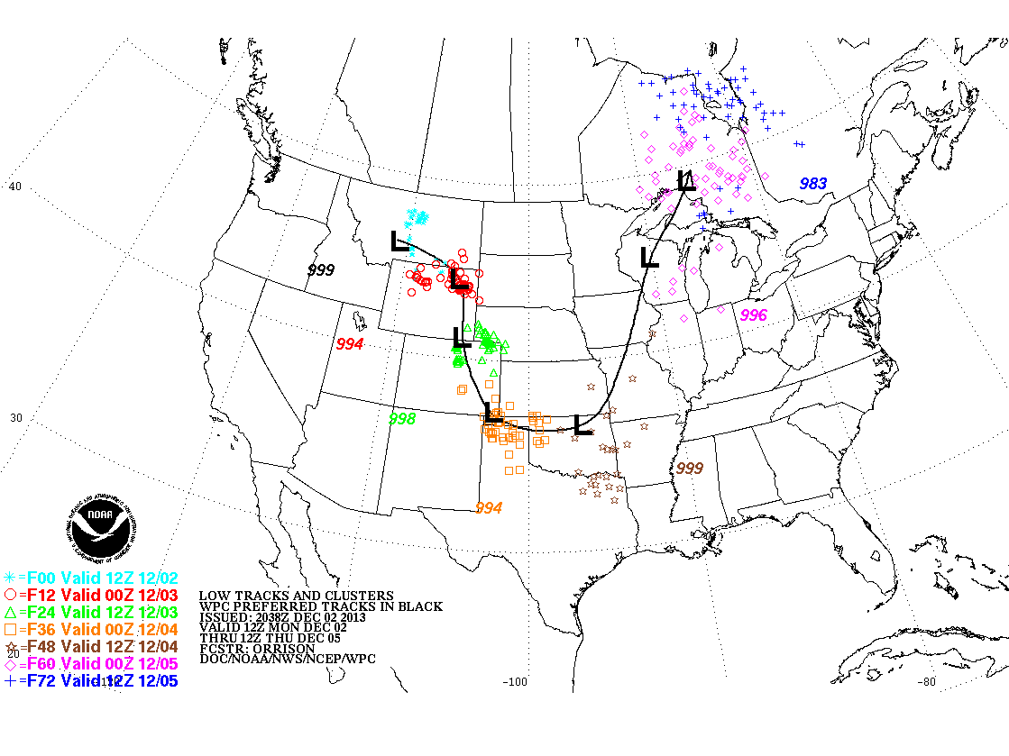
Track critical
As always the track of the surface low is critical to who gets the most snow. In many winter storms the axis of heaviest snow runs about 80 to 120 miles northwest of the surface low track. The latest model runs show a distinct trend toward a more southerly track. That puts the metro in play for increased snowfall totals, with the heaviest snows still favoring central and northeast Minnesota.
Riding the rain-snow line
Why should this storm be easy? The latest trends place the rain snow line right over the Twin Cities late Tuesday. That makes it that much harder to say with real precision who will get heavy wet snow, and who will get rain. Here's the weather depiction at 7pm Tuesday evening from NOAA's Digital Forecast Database.

Snowmageddon up north, huge metro range?
A forecast of 1" to 8" in the Twin Cities?
That's what one model run (NOAA's NAM) suggests as a range from south to north across the Twin Cities by Wednesday night. It sounds far fetched, or like a weather guy cop out...but if the rain snow line sets up right over the metro it may not be that far from reality. Most of the snow should fall Tuesday evening into Wednesday morning.
My early hunch on totals? A range of 1" south to 6"+ north metro is entirely possible. If Tuesday morning's runs take the system even further south, metro snowfall forecasts will rise even more.
Here's the NAM snowfall output from late Tuesday night. I wouldn't bet the farm on this solution yet, but it gives you a good idea on just how big the eventual snowfall range could be over the metro.
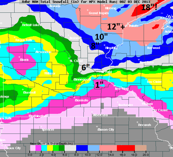
It still looks like the heaviest snow will fall north of the Twin Cities. Draw a line from Fargo through Brainerd and Duluth and that may be the heavy snow axis with a good 6" to 12"+...with some staggering 20" to 2 foot totals near Duluth and along the North Shore ridge line all the way to Grand Marais and the Gunflint trail. That should get the juices flowing for northern resorts and snowmobile enthusiasts.
What could go wrong?
Overall confidence on eventual metro snowfall is still low. There is still a (small) chance this storm could bust for the Twin Cities...or track further south and smack parts of the metro with even heavier snowfall totals. Here's Environment Canada's' GEM model for Wednesday morning, which takes the storm even further south and slows it down...and blasts the metro with even heavier snowfall totals.

Hourly break down
With the storm still evolving this may be too much of an attempt at precision, but the temperature profiles suggest enough warm air mixing in Tuesday PM for some mixed rain...trending to all snow Tuesday evening into Wednesday.

Siberian Express: -20F for the metro?
I'm not buying into -20 degrees for the Twin Cities just yet...but the arctic assault coming in behind this storm is impressive. The Euro model is cranking out lows between -17 to -24 for the Twin Cities in the next week...and 7 consecutive sub-zero mornings. It may be overdone, but this is going to be a significant test of battery draining cold.

I'll update metro snowfall Tuesday morning, but get ready...real winter is here to stay for at least the next two weeks.