A taste of mild temperatures; a big gulp of cold Sunday
I ventured outdoors to soak up some of the warmest readings in a month. Yes, I did say warmest. With a high of 40 degrees in the Twin Cities today, we came up only 6 degrees shy of the record of 46 set in 1959.
How about the run-up on the thermometer in Ely in the last 16 hours! At midnight Ely was 17 below zero. At 4 p.m. CST the temperature was 32 degrees.
The national weather map for noon Saturday shows the leading edge of Arctic air leaking into northern Minnesota.
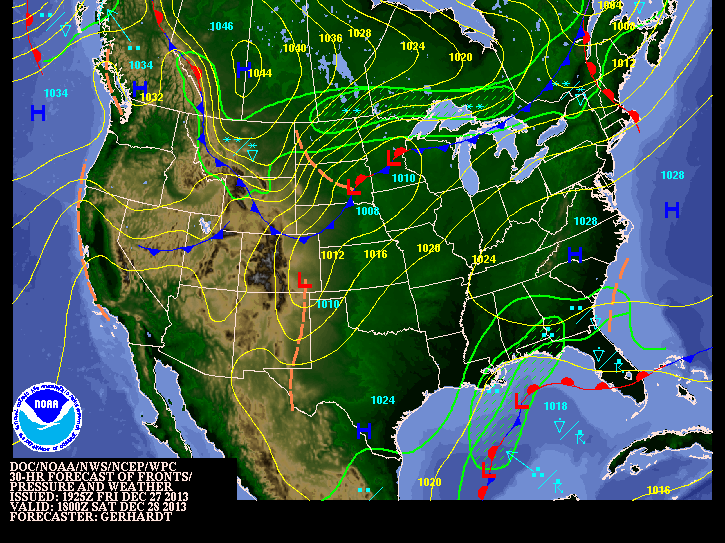
Milder air will still be in place over southern Minnesota through Saturday afternoon.
Create a More Connected Minnesota
MPR News is your trusted resource for the news you need. With your support, MPR News brings accessible, courageous journalism and authentic conversation to everyone - free of paywalls and barriers. Your gift makes a difference.
Snow is likely to develop in the colder air over northeast Minnesota and track south and east on Saturday night. The most likely area to receive a couple of inches of fresh snow would be from Grand Marais to Marquette, Michigan.
From the Weather Prediction Center; snowfall probabilities of two inches or greater from Saturday afternoon to Sunday morning.
[image]
Under the cover of darkness the icy blast will invade the upper Midwest. By Sunday morning the thermometers will be quivering in the cold.
[image]
Highs on Sunday are forecast to remain below zero in all but perhaps extreme southern Minnesota.

Wind chill advisories and warnings will likely be extended over much of the region Saturday and Sunday.
[image]
Wind chill values of 25 below zero or colder are dangerous. We could see wind chill readings approach 40 below zero Sunday morning. The National Weather Service will have updated weather information here.
Be cautious of near-blizzard conditions, particularly in rural areas, late Saturday night and Sunday morning as gusty winds create blowing and drifting snow.

[image]
New Year's morning is likely to be bitter cold. If you have plans on New Year's Eve, you may wish to forego fashion for warmth if venturing outdoors.

I'll leave you with the National Weather Service Outlook for January, which was issued a week ago. This outlook is open to revision on December 31st.


Paul Huttner is back on Monday. Have a great 2014.