Winter Outlook 2013-’14: Mixed signals, mostly ‘average’ winter overall?
Rolling The Weather Dice
Long range seasonal forecasting is a little like a trip to Vegas. It's full of anticipation. It's exciting. And there are long odds against you coming out ahead.

Seasonal outlooks should come with disclaimers. For entertainment purposes only. Buyer beware. Just sign this weather waiver...and read on.
Climate forecasters know there are few clear signals this fall that point in one direction this winter. Already this fall I have seen wildly varying winter outlooks for the Upper Midwest and US ranging from 'Snomageddon' to a mild winter.
Create a More Connected Minnesota
MPR News is your trusted resource for the news you need. With your support, MPR News brings accessible, courageous journalism and authentic conversation to everyone - free of paywalls and barriers. Your gift makes a difference.
The leading indicators of winter weather across the US are split. The current El Nino Southern Oscillation 'ENSO neutral' phase offers no clear signal on winter weather from the tropical Pacific. The other 'oscillations' and Siberian Snow cover tell a story that's murky at best, or point in completely opposite directions.
Oh...and did I mention the Weather Lab Woolly Bear Caterpillars have ginormous wide brown bands this fall? Probably as accurate an indicator of the winter ahead as anything I can find this fall.

So what indicators do climate forecasters look to when making seasonal forecasts? And what clues do we have about the winter ahead? The safe forecast? Colder with some snow and ice this winter.
Here's a look at what we know...and don't know about the upcoming winter of 2013-'14.
A look back at last winter
Last winter came in fairly typically, then roared out like a ferocious lion in the second half. Duluth racked up 129.4 inches of snow last winter, the 3rd snowiest year on record.
The Twin Cities snowfall tally ran 67.7 inches, more than a foot above the 30-year seasonal average of 54 inches. The season was back loaded with snowfall with frequent, sometimes heavy snows from February through April.
Temperatures ended up exactly 1 degree warmer than average overall for meteorological winter. (Dec-Feb) MSP Airport recorded 12 days with sub zero temps last winter.

Truth in advertising: How did my forecast turn out last winter?
As I said above, seasonal forecasting is often littler better than a 50/50 proposition in a good year. I'm a broadcast and synoptic meteorologist, not a seasonal expert...and there is a difference. My seasonal weather forecast and $4 (including tip?) will buy you a latte at Caribou.
That said, I came out pretty well on temps last winter, and came up short on snowfall. Here's an excerpt from what I posted last November 1st on Updraft, with my comments and verification below.
Overall trends:
I expect bigger week to week and month to month fluctuations this winter compared to last winter in both temperature and snowfall.
Snowfalls and cold arctic outbreaks will likely be punctuated by milder weeks that may eat away at snow cover this winter.
Comment: This worked out pretty well. A 10 inch snowfall on December 9th melted down to 1 inch by the 16th after a 4-day thaw that peaked at 40 degrees. A similar pattern occurred in January. Reported snow depth at MSP was either zero or a trace from January 12th through the 27th.
The overall character of this winter should be colder and snowier than last year.
Comment: True. Last winter was colder and much snowier than the winter of 2011-'12 (23.3 inches)
Temperature: (December-February) Milder than average
Overall I am leaning toward a winter that’s still warmer than average, but noticeably colder than last winter.
MSP & most of Minnesota +1F to +3F (December through February)
Comment: This was on the mark. The Twin Cities ended up exactly +1 degree vs. average last meteorological winter. (Dec-Feb)
I also think we’ll many more sub-zero night that last winter’s paltry 3…but far fewer than the longer term average of 39. At this point I’d lean toward 10 to 15 nights below zero in the metro this winter.
Comment: Again, this worked. MSP Airport recorded 12 sub-zero mornings last winter.
Snowfall: (Total season snowfall) Near average
40″ to 50″ for the Twin Cities metro area.
Comment: Not so much. I came up shy on snowfall last year as the late season snow blitz pushed the seasonal twin Cities total to 67.7 inches.

Winter 2013-'13: The variables
As dicey as seasonal outlooks can be, there'a a lot of science that goes into them. Climate forecasting is still an evolving discipline. Here are some of the tools forecasters use to make winter season forecasts, and where they are trending for this winter.
The "Oscillations"
El Nino Southern Oscillation (ENSO) is the most well known, and probably has the most identifiable signals for US weather in El Nino and La Nina phases. It's not a slam dunk, but El Nino winters often have a mild bias in Minnesota and the Upper Midwest. La Nina winters can lean colder and snowier.

The trend for 2013-'14 is ENSO neutral, with a slight bias toward a weak El Nino developing by spring.
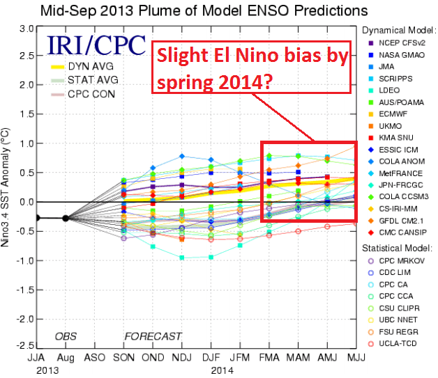
ENSO neutral lends few clues to the upcoming US winter, and NOAA's Climate Prediction Center is officially saying there is 'equal chances' of above and below average temperatures this winter.

The development of a full blown El Nino next year could favor a mild winter in 2014-'15.
Siberian snow cover: The latest 'sexy' winter forecasting tool?
Many commodities and other forecasters look to fall snow cover in Siberia as a clue to winter in the US. Some forecasters see correlations as high as 60 to 70 percent between above average Siberian snow cover in fall, and colder than average US winters. Big snow in Siberia can favor a negative phase of the Arctic Oscillation...which favors sending bitter arctic outbreaks south into the US.

So far this fall snow cover is running above average in Siberia. Here's the latest map from the Rutgers Snow Lab.

Here's an excerpt from a recent Bloomberg piece on the effect of Siberian snow cover.
The weather half a world from Central Park can set off atmospheric events that result in icy air descending from the North Pole in December and January, driving U.S. temperatures down and natural gas and heating oil use up, according to Judah Cohen, director of seasonal forecasting at Atmosphere & Environmental Research in Lexington, Massachusetts.
“It’s the best winter predictor that we have,” Cohen said in a telephone interview. “We haven’t made a forecast yet, but we’re watching it closely and the snow cover has definitely been above normal so far.”
The more ground covered by snow across northern Europe and Asia at the end of October, the greater the chances of triggering a phenomenon known as the negative phase of the Arctic Oscillation. That would flood North America, Europe and East Asia with polar air and possibly erect a blocking effect in the North Atlantic that would bottle up the cold in the U.S.
In September, 2.36 million square kilometers (911,000 square miles) of northern Europe and Asia were covered by snow, according to the Rutgers University Global Snow Lab. That compared with the 1981-2010 mean of 1.5 million.
“It’s running well above normal,” said Matt Rogers, president of Commodity Weather Group LLC, a commercial forecaster in Bethesda, Maryland. “Through the last week of September, it’s the highest snow total in Eurasia since 1977.”
The bottom line is snow cover has run above average in Siberia this fall, but has faded some in late October. Higher than average snow cover may favor a colder than average US winter, but recent trends may temper that assessment.
Decadal Trends: Warmer winters
Long term trends show the background hum, the Muzak of our weather patterns these days is flavored by climate changes. Each year can be different, but overall trends strongly favor warmer winters in Minnesota. Our winters feature 3 times more rain and ice in recent decades according to Dr. Mark Seeley at the UM. Sub zero nights are harder to come by in the Twin Cities and -20 is a real reach these days.
A recent analysis from Climate Central show Minnesota is the fastest warming sate in the US in winter since 1970.

It takes a brave soul to forecast a colder than average winter overall for Minnesota given the long term trends.

Bottom Line: An 'average' winter in 2013-'14?
If all winter forecast are low confidence affairs, this one is even more so. There are few strong clues to this winter in my analysis. That said, here's my best shot at a winter outlook for 2013'14.
Buyer beware.
Temperature: (December-February)
Overall I see the best odds favor near average temperatures winter. Temps averaging -0.5F to +1.5F above average seem most likely to my eye.
I think we'll see more sub-zero nights than last winter (12) but not as many as the overall average in the latest set of updated 30-year averages for the Twin Cities, which is 23. I'll place my bets on 15-20 sub-zero nights at MSP this winter.
Snowfall: Enough to ski, snowmobile, shovel and plow
I don't see any clear direction in snowfall trends this winter. I'll play it down the middle, and go with 48 to 58 inches at MSP this winter. The 30 year average is 54 inches.
Earlier spring in 2014?
This may be part hopeful and optimistic after the debacle that was the Spring of 2013. But if the potential for El Nino takes hold early... a 'split' jet stream in late winter could lead to a milder trend late winter into spring. If that happens look for southern California to get pounded with heavy, flooding rainstorms in February.
Hopefully we won't be dealing with heavy April...and May snow storms in Minnesota next spring.

As always, weather fingers and toes crossed.
Have a great winter Minnesota!