Brazil drought, Sahara air may explain quiet hurricane season
It's been a remarkably quiet Atlantic hurricane season, so far. That has perplexed hurricane forecasters, who called for an active season. The National Oceanic and Atmospheric Administration forecast seven to 11 hurricanes on May 23. Colorado State University called for 9 hurricanes in their June 3 forecast.
So far those forecasts have been a bust, and today Hurricane Humberto became the first Atlantic hurricane of the season far off in the eastern Atlantic, just three hours before the record for latest hurricane.
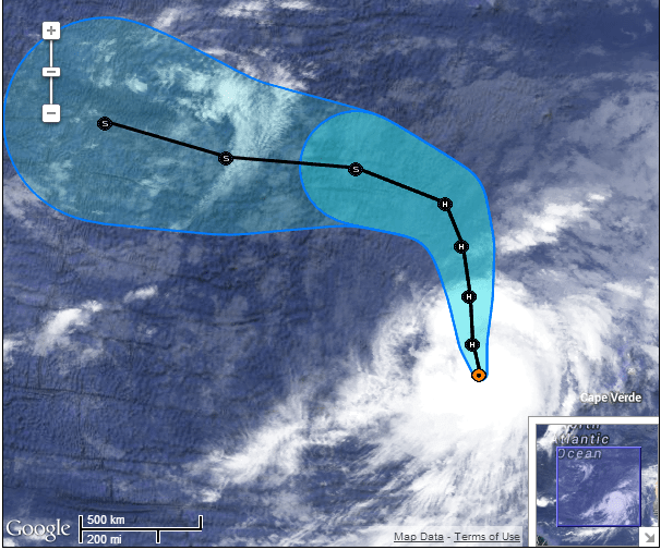
NOAA's National Hurricane Center tagged Humberto the season's first hurricane at 5 a.m. eastern time today. Hurricane Gustav debuted at 8 a.m eastern time on September 11, 2002, the latest ever in the season for the 1st Atlantic hurricane.

Sept. 10 marks the historical peak of seasonal Atlantic hurricane frequency. Since the Hurricane Hunters first began flying in 1944, there has been only one hurricane season (Gustav in 2002) that made it past the halfway point without a hurricane.
Create a More Connected Minnesota
MPR News is your trusted resource for the news you need. With your support, MPR News brings accessible, courageous journalism and authentic conversation to everyone - free of paywalls and barriers. Your gift makes a difference.

Forecast: Continued calm before the storm?
Hurricane forecasters look at something called accumulated cyclone energy to gauge hurricane potential. So far, 2013 is one of the lowest years on record for ACE in the tropical Atlantic, the lowest first half of the hurricane season since 1966 according to Weather Underground hurricane expert Jeff Masters.

One puzzling question: Why is the Atlantic so quiet when sea surface temperatures are so warm?

The answer may lie in dry air from the biggest drought in Brazil's history this year and from high levels of Saharan dust that has suppressed hurricane formation. Whatever the reason, the short term Atlantic forecast calls for continued quiet for now.
Too early to write off a major U.S. hurricane strike yet
In spite of the near record quiet so far, it's way too early to write off a major U.S. hurricane strike for 2013. Still, hurricane guru Jeff Masters elaborates on why the season looks quiet for the foreseeable future.
Forecast for the next two weeks: below average activity
The main reason for the quiet first half of the season has been the large amount of dry, stable air over the Atlantic. The primary source of this dry air has been the Sahara desert of Africa. However, dry air from Northeast Brazil may also have contributed, argues wunderblogger Lee Grenci.
That region of the country experienced a record $8.3 billion drought in 2013--the most expensive natural disaster in Brazil's history. Even with all the dry air we've seen over the Atlantic in 2013, it is really remarkable that activity has been so low when all of the other factors--lack of an El Niño, wind shear near climatological averages, an active African Monsoon spitting out plenty of tropical waves, and above average ocean temperatures--have favored development.
Instability increased over the tropical Atlantic over the last few days of August and the first week of September, thanks to the influence of the Madden Julian Oscillation (MJO), a pattern of increased thunderstorm activity near the Equator that moves around the globe in 30 - 60 days. Instability was also boosted by a Convectively Coupled Kelvin Wave (CCKW) that brought rising air to the Atlantic.
This increase in instability helped the formation of Gabrielle, Humberto, and Tropical Depression Eight, and may help boost the odds of a potential tropical storm forming this weekend over the Southwestern Gulf of Mexico's Bay of Campeche. The influence of the MJO is fading over the Atlantic, though.
Beginning next week, we will be entering a phase of the MJO where it will likely bring more stable, sinking air to the Tropical Atlantic. This suppressed phase of the MJO could last through the first week of October. The models are also pointing to another outbreak of dry air from the Saharan Air Layer (SAL) coming off the coast of Africa this weekend, which will keep the Tropical Atlantic dryer than usual next week.
The steering pattern over the next two weeks features a strong trough of low pressure over the U.S. East Coast, giving high odds that any hurricane that manages to form and approach the U.S. will recurve out to sea, without affecting any land areas. So keep your fingers crossed--we're doing unusually well for this point in the hurricane season, with no landfalling hurricanes, and it looks like we have above average chances of keeping it that way deep into September.
Let's hope the Atlantic avoids sending another late season Sandy our way this year.