Spotty clouds and showers today; Thursday thunder and severe risk ahead
Mixed weather bag
It looks like we'll see a little something for everyone in the next few days in Minnesota's weather.
A weak upper level disturbance will produce some mixed clouds, sun and showers today. A stronger shot of Canadian air brings more widespread showers and thunderstorms tomorrow and a slight risk for severe storms.
The big picture? A weaker jet stream and less wind shear is causing a "tornado drought" in the U.S. this year. That's a good thing, but it brings some other meteorological oddities along with.
Create a More Connected Minnesota
MPR News is your trusted resource for the news you need. With your support, MPR News brings accessible, courageous journalism and authentic conversation to everyone - free of paywalls and barriers. Your gift makes a difference.
The weather maps have been a little strange at times this year. If you listen to MPR's Climate Cast, you've heard me talk about changing jet stream patterns as Earth's climate warms overall.
It's one thing to talk about that in theory. It's just plain weird to see them playing out on the daily weather maps.
These are not the weather maps of my youth, when I started forecasting about 30 years ago. Yes, weather systems are moving slower these days, and daily weather patterns seem to be stuck in a rut.
What started as a nice warm July seems to have given way to a prolonged September preview.
77 degrees -- high temperature at the Minneapolis-Saint Paul airport on Tuesday
83 degrees -- average high for July 23

Rain returns to the forecast:
Tuesday's high of 77 degrees at Minneapolis-St. Paul International Airport felt more like early September. The last time we saw a high temp cooler than yesterday was 75 degrees on June 15, about five weeks ago. Temps again hover in the 70s today. Look for more clouds today, with a few spotty showers sliding by for good measure.
Thursday Severe Risk
The next shot of reinforcing Canadian air arrives Thursday with an unseasonably strong cold front for late July. The timing may produce a few severe storms Thursday afternoon and evening.
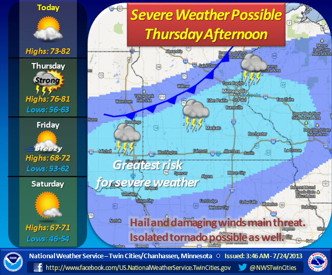
NOAA's Storm Prediction Center paints southern Minnesota as the favored area for severe storms Thursday.

Heavy downpour potential?
The slow moving front may trigger some slow moving storms with potentially heavy downpours. Most models and NOAA's rainfall forecast crank out a general .25" to 1" for Minnesota Thursday.

The outlier is NOAA's North American Mesoscale model, which reels off an impressive 2.8" rainfall spike in the Twin Cities metro area Thursday!

This is probably overdone, but it gives you an idea that some of the storms may be slow movers and could dump some heavy rainfall totals.
Weekend Chill: 30s up north Saturday morning?
The air mass nosing into Minnesota this weekend will feel more like Labor Day than the Dog Days of summer.
Highs may only hover around 70 degrees in the metro Saturday. And lows may dip into the upper 30s around International Falls, Ely and the BWCA this weekend. Campers may need the heavy sleeping bag up north.

The overall pattern looks a bit warmer next week, but I just don't see any prolonged heat or sustained 90s in sight for the next week or two.