Free AC: Dew points plunge behind cool front (Record 7 straight days in “slight risk” for MSP?)

Breathing Easier
A fresh breeze is blowing into Minnesota overnight and Thursday.
Gone: 70+ degree tropical dew points that fueled another 4" to 8" rain burst (and another 500 year flood?) near Fargo.
In: A drying fresh westerly breeze with dew points falling into the comfy 50s by late Thursday.
Create a More Connected Minnesota
MPR News is your trusted resource for the news you need. With your support, MPR News brings accessible, courageous journalism and authentic conversation to everyone - free of paywalls and barriers. Your gift makes a difference.
Tee time or boat ride anyone?
Wednesday was day 7 in a row with an SPC "slight risk" over the Twin Cities. I can't recall that happening before. It appears the severe siege is over for a few days. Grateful.
The outlook for the 4th is just coming into view. Last year we sweltered in 101F heat. This year? Not a chance. More on the outlook for the 4th and why Twin Cities NWS has finally said good riddance to drought in Minnesota.
Now can somebody please turn off the faucet?

Anatomy of a summertime cool front:
You don't need a degree in meteorology to find a Minnesota cold front in fall or winter. The strong slap in the face can be sudden...and often comes with a gush of frigid wind that sends you scurrying into the nearest heated space.
In summer Minnesota "cool fronts" are more subtle. A few storms blow by...a subtle shift in wind direction into the west as humidity gradually eases. Here's a look at frontal passage (FROPA) in the Twin Cities Wednesday afternoon via the GOES 1km visible satellite shot. I've overlaid winds and dew points to show the transition to a much drier air mass.

The front ushers in drier more pleasant air with dew points plunging into the 50s in the next 24-36 hours. Time to turn off the AC and open the windows?

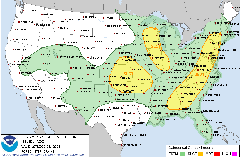
Unlucky 7: MSP under "slight risk" 7 days in a row
NOAA's Storm Prediction Center gives us a heads up each day by issuing "convective outlooks" that preview and highlight potential severe weather risk areas. Wednesday marked the 7th day in a row that MSP was in a "slight risk." That's quite a string...and I can't recall that happening before. Normally weather systems move along in a few days and the risk aras go with them. Not this year in the (now severe) Monsoon of 2013. Another sign of climate change induced "stuck" weather patterns?
Here's some good news for storm weary Minnesota. The "slight risk" string ends Thursday as drier air and sunshine moves in. The severe risk areas shift east of MSP...and a good chink of the eastern USA is under the severe threat Thursday.
It takes a (flash) flood...Twin Cities NWS issues "final" drought statement.
You don't need a weatherman to know which way the wind blows. Or in this case to tell you the drought is long since over.
Our “June-soon” deluge has erased any doubt that drought is holding onto small portions of western Minnesota. Here’s an excerpt from the “final” drought statement from the Twin Cities NWS.
PUBLIC INFORMATION STATEMENTNATIONAL WEATHER SERVICE TWIN CITIES/CHANHASSEN MN
416 PM CDT WED JUN 26 2013
...PUBLIC INFORMATION STATEMENT...
FINAL DROUGHT STATEMENT DUE TO IMPROVING CONDITIONS:
...SEVERE DROUGHT CONDITIONS HAVE BEEN ELIMINATED OVER THE REMAINING SMALL
PORTION OF WEST CENTRAL MINNESOTA...
...MODERATE DROUGHT CONDITIONS DECREASE AGAIN OVER PORTIONS OF WEST CENTRAL MINNESOTA...
...ABNORMALLY DRY CONDITIONS RETREAT NOTICEABLY OVER SOUTHERN MINNESOTA AND ARE CURRENTLY REPORTED OVER MUCH OF WEST CENTRAL AND SOUTHWESTERN COUNTIES...
SYNOPSIS...
DROUGHT CONDITIONS ONCE AGAIN IMPROVED MARKEDLY DURING THE PAST MONTH ACROSS MUCH OF THE REGION. DURING THE PAST 7 DAYS ALONE
...RAINFALL AMOUNTS OVER SOUTHERN MINNESOTA AVERAGED BETWEEN ONE AND ONE HALF INCHES...TO NEAR THREE INCHES. WIDELY SCATTERED LOCATIONS ACCUMULATED BETWEEN 4 TO JUST OVER SIX INCHES OF MOISTURE. MUCH OF WEST CENTRAL WISCONSIN AVERAGED BETWEEN AND THREE INCHES OF RAINFALL DURING THIS PERIOD.
VERY SLOW MOVING STORM SYSTEMS COUPLED WITH LARGE AMOUNTS OF GULF OF MEXICO MOISTURE WERE RESPONSIBLE FOR THE ENORMOUS AMOUNTS OF PRECIPITATION DURING THE MONTH OF JUNE ACROSS THE REGION. RAINFALL AMOUNTS OVER WEST CENTRAL WISCONSIN...VARIED FROM 3 TO 6 INCHES...WHICH WAS BETWEEN ONE HUNDRED AND 175 PERCENT OF NORMAL. IN SOUTHERN MINNESOTA...PRECIPITATION MAINLY BETWEEN 125 PERCENT TO 200 PERCENT OF NORMAL WERE REPORTED. A SMALL PORTION OF WEST CENTRAL MINNESOTA PICKED UP BETWEEN 200 AND 300 PERCENT OF NORMAL RAINFALL.
SUMMARY OF IMPACTS...
LOCAL AREA AFFECTED.
...MINNESOTA...
THE ABNORMALLY DRY /D0/ OR MODERATE /D1/ DROUGHT CONDITION AREA WAS MAINLY WEST OF A LINE...FROM WATKINS TO MANKATO TO ST JAMES.
...WISCONSIN...
THERE ARE NO SEVERE OR MODERATE DROUGHT CONDITIONS IN WEST CENTRAL WISCONSIN. THE PREVIOUS ABNORMALLY DRY REGION OVER MUCH OF POLK COUNTY HAS BEEN ERADICATED.
Expect even fewer "pretty colors" as this week's updated U.S. Drought Monitor comes out Thursday morning.

4th of July: Parades, Fireworks and Rain Showers?
Perhaps the character of the past 2 summers in Minnesota will be summed up by the 4th of July weather.
-Last year...101F in the metro under a blazing sun.
-This year? Mixed clouds...temps in the 70s and scattered showers?
It's too early to say for sure, but here's the latest Euro model idea of the 4th.

Plan for at least some rain and hope for better?
Paul Huttner