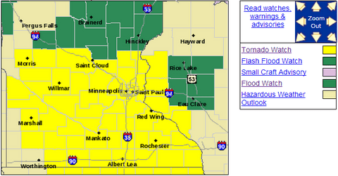
Tornado Watch until 9pm includes the Twin Cities
Here we go.
NOAA's Storm Prediction Center has issued a Tornado Watch until 9pm tonight for most of southern Minnesota including the Twin Cities metro area.
URGENT - IMMEDIATE BROADCAST REQUESTED
Create a More Connected Minnesota
MPR News is your trusted resource for the news you need. With your support, MPR News brings accessible, courageous journalism and authentic conversation to everyone - free of paywalls and barriers. Your gift makes a difference.
TORNADO WATCH NUMBER 180
NWS STORM PREDICTION CENTER NORMAN OK
110 PM CDT SUN MAY 19 2013
THE NWS STORM PREDICTION CENTER HAS ISSUED A
* TORNADO WATCH FOR PORTIONS OF
CENTRAL AND EASTERN IOWA
SOUTHERN AND CENTRAL MINNESOTA
WESTERN WISCONSIN
* EFFECTIVE THIS SUNDAY AFTERNOON AND EVENING FROM 110 PM UNTIL
900 PM CDT.
* PRIMARY THREATS INCLUDE...A FEW TORNADOES POSSIBLE SEVERAL DAMAGING WIND GUSTS TO 65 MPH POSSIBLE A FEW LARGE HAIL EVENTS TO 1.5 INCHES IN DIAMETER POSSIBLE
THE TORNADO WATCH AREA IS APPROXIMATELY ALONG AND 105 STATUTE MILES EAST AND WEST OF A LINE FROM 70 MILES NORTH NORTHEAST OF REDWOOD FALLS MINNESOTA TO 25 MILES SOUTH SOUTHEAST OF WATERLOO IOWA.
PRECAUTIONARY/PREPAREDNESS ACTIONS...
REMEMBER...A TORNADO WATCH MEANS CONDITIONS ARE FAVORABLE FOR TORNADOES AND SEVERE THUNDERSTORMS IN AND CLOSE TO THE WATCH AREA. PERSONS IN THESE AREAS SHOULD BE ON THE LOOKOUT FOR THREATENING WEATHER CONDITIONS AND LISTEN FOR LATER STATEMENTS AND POSSIBLE WARNINGS.
-Latest Twin Cities radar loop
-Latest Warnings from Twin Cities NWS
Storms will develop this afternoon in an increasingly unstable air mass and move north.
Stay tuned and expect severe weather warnings this afternoon and evening.
Paul Huttner