A day of record toasty weather
A breezy push of hot, dry air from the south coupled with a strong mid-May sun pushed afternoon temperatures into record territory.
The temperature of 98F reached in the Twin Cities by 5 p.m. is not only a new record high for this date, but also the hottest ever measured at the official thermometer so early in the year.
Southern Minnesota got blasted by the hottest temperatures. Fairmont and Albert Lea were among those cities that reached the century mark. St. James reported 102 earlier in the afternoon.
A heat advisory continues until 8 p.m. from the Twin Cities to south central Minnesota including Redwood Falls, Mankato and Albert Lea.
Create a More Connected Minnesota
MPR News is your trusted resource for the news you need. With your support, MPR News brings accessible, courageous journalism and authentic conversation to everyone - free of paywalls and barriers. Your gift makes a difference.
And it was dry. When Albert Lea touched 100 degrees at 4 p.m., it also reported a dew point of just 27. Combine those two and you get a desert-like relative humidity of just 7 percent.
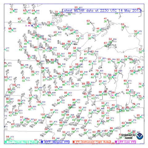
Another change is coming in the form of a north-south cold front crossing Minnesota toward Wisconsin. And the wind is stronger on the back side of the front than ahead of it. This map of weather station data as of 5:30 p.m. shows the sharp wind shift that locates the front and also the stronger winds from the northwest behind it:
Source:NOAA
Thunderstorms have been igniting over the southeast corner of the state and are racing eastward into Wisconsin. They show up nicely on satellite imagery:
Source:NOAA
Tuesday will be a much different day with cooler, pleasant high temperatures in the 70s
Look for lots of wet weather with periods of showers and thunderstorms from Thursday night right through the weekend. An inch or two -- or maybe three -- of rain could be on tap.
Bill Endersen