Nicer Sunday; Rain returns tonight; Models split on rain/snow by Wednesday
10" snowfall total at Two Harbors Saturday
Rain returns to the metro Sunday night
Create a More Connected Minnesota
MPR News is your trusted resource for the news you need. With your support, MPR News brings accessible, courageous journalism and authentic conversation to everyone - free of paywalls and barriers. Your gift makes a difference.
Aiming for average.
That's the benchmark recently for Minnesota's weather. There are few times when "average" seems like a laudable goal, but lately we'll take it.
"Average" this weekend in the metro is 53F/33F. We'll come close by Sunday.
The weather maps continue to look busy for the next week, System #1 tracks through this weekend. Forecast models are split on the track and temp profile for system #2 next week.
Will it be mostly rain...or snow?
In this Updraft we track incoming weather systems and keep an eye on the horizon for a much bigger warm up.
True spring weather has to come sooner or later.
Somewhere daffodils and tulips are waiting for those first precious 60 degree days.
Weekend Split: Shower Saturday, Nicer Sunday
At least it's mostly rain.
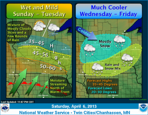
This weekend's weather maker is bringing a rainy mix to Minnesota. A few wet snowflakes will mix in, but as "warm advection" takes over most of this weekend's precip will fall as rain in the metro.
The models center between .25" and .50" rainfall totals in the metro and southern Minnesota.
Snow North:
Enough cold air will linger for a band of snow that includes Brainerd, the Iron Range, Duluth and the North Shore communities.
Some of the models suggest a more potent system near Duluth and along the North Shore ridge into northwest Wisconsin. It's possible some may be plowing 6"+ by Sunday??
Sunday: Sunnier & nicer day this weekend
Place your bets for Sunday as the best day to get outside for that walk of to take in the still ice crusted lakes one last time.
A weak bubble of high pressure should mean some peeks of sun, and lighter winds. Temps may stagger to near 50F in the metro by around 3pm Sunday.
Not bad!
Next Week: Definitely wet... but rain or snow?
I feel like a (weather) air traffic controller guiding storm systems into Minnesota since our pattern shift in February,
Another, bigger wetter system appears headed for the Upper Midwest next week.
There are huge forecast model discrepancies with this system. The GFS favors a warmer northern track that would keep precip mostly rain in the metro.
The Euro favors a colder system and the potential for a mini "April Snowmageddon."
Usually the Euro is the superior model, but lately it has done a lot of flip flopping and the GFS has a better track record recently.
The recently upgraded Canadian GEM model is a blend of the 2. The GEM favors mostly rain in the metro Monday into Tuesday then ending with a brief blast of heavy wet snow Wednesday morning.
All of the forecast models seem to suggest there could be heavy snow in central Minnesota next week.
Stay tuned as we let the models hopefully find consensus as the system moves inland over the denser upper air and surface network in the western USA late this weekend.
Less garbage in...better product out... so to speak.
Seeley: Soils thawing out in southern Minnesota
Here's an interesting tidbit as soils begin to thaw from my MPR colleague Dr. Mark Seeley in this week's Weather Talk.
MPR listener question: How deep is the frost right now and will much of the rain in the next couple of days soak into the ground?
Answer: With the loss of snow cover the soil is beginning to thaw from the surface downward more rapidly. In southern Minnesota and the Twin Cities area the top 5 to 8 inches of soil has thawed out, however there is still a frost layer between 8 and 20 inches in most places. Further west and north in the Red River Valley frost still extends down to 30-40 inches deep and there is relatively little surface thawing so far. The rainy pattern we expect to see develop for the weekend and extend into next week will help accelerate the thaw, and indeed some of the rainfall will go into the dry soil, but not too much depth.
A check of soil temps in Waseca Friday shows the top 4" of soils has indeed thawed above the freezing mark.
"True Spring" in about 10 days??
The longer range outlook continues to insist on a strong push of much warmer air around Tax Day 2013.
A major shift to a "positive AO" could finally signal a true spring warm up.
The GFS is still cranking out a string of 60s...and a shot at 70F in the next 2 weeks.
It has to get here sooner or later (right?) and pushing our first 60s much past mid-April would be highly unusual.
Hang in there. Things could look a whole lot better in 2 weeks.
Weather fingers & toes crossed.
Ice Out Loon In Thursday:
I'm excited and honored to be hosting again for this year's annual "Ice Out Loon In" event for the Freshwater Society Thursday at The Lafayette Club.
The event features excellent food, company and auction items and the annual "loon calling" contest.
The Freshwater Society is a big supporter of keeping our Land of 10.000 Lakes clean and clear, and supports water research around the world.
Freshwater is the keeper of detailed records in ice out for Lake Minnetonka for decades.
Bring your warmth. Maybe we can make the ice melt sooner?
Science Museum of Minnesota celebrates "Stewardship and Science" for Earth Day 2013:
I'm also stoked to be part of the SMM's Earth Day 2013 program on April 20th.
I'll be giving the keynote on Minnesota's Changing Climate. What will Minnesota look like in 2040? Place your bets.
Here's a preview of the big Earth Day extravaganza at SMM on April 20th.
Hope to see you there.
PH