Storm warnings from Montana to Minnesota
Winter Storm Warnings have been posted from Montana to northwestern Indiana including most of Minnesota as well as western and southern Wisconsin.
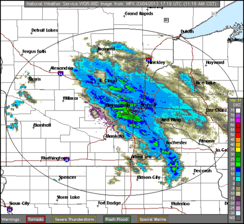
A band of snow now sliding northeast across the metro area should precede a lull in the storm - at least in the eastern part of the state. Snowfall this afternoon will be mainly in the northwestern quarter of Minnesota with some light snow and flurries popping up elsewhere.
From the NWS radar in Chanhassen:
Create a More Connected Minnesota
MPR News is your trusted resource for the news you need. With your support, MPR News brings accessible, courageous journalism and authentic conversation to everyone - free of paywalls and barriers. Your gift makes a difference.
The morning forecast models continue to insist that the snowfall will move southeast and intensify tonight. A band of moderate to occasionally heavy snow is likely to develop over east central and southeast Minnesota as well as western Wisconsin by around midnight and then continue into the morning. About 4 to 7 inches of snow is likely in that area overnight and then 2 to 4 more inches on Tuesday.
Here is where the morning NAM model is predicting significant precipitation in the six hours ending at 6AM tomorrow:
Credit: NOAA/College of DuPage
The Tuesday morning commute in the metro area will be tricky.
By the time the storm winds down, much of Minnesota will have picked up at least 6 to 10 inches of snow with some 10- to 12-inch amounts likely in eastern and southeastern Minnesota. The Arrowhead and the southwestern corner of the state will get the least with just a few more inches likely.
Eventually, the storm will slide off to the southeast toward Madison, Milwaukee and Chicago tomorrow. Madison and Chicago, in particular, could end up in the 5- to 10-inch range.
Bill Endersen